Cooler weather has settled over Southern Manitoba and while it won’t stay below normal for long, we won’t really be hitting above normal temperatures any time soon, either. The week ahead looks like a middle-of-the-road week with some sun, some cloud, an a chance for some showers.

Today will bring clear skies to Winnipeg with diminishing winds. Our expected daytime high of 2°C will be a whopping 9°C below our normal daytime high of 11°C for this time of year. Tonight we’ll drop down to a chilly -7°C under clear skies.
Tomorrow will start off sunny and then cloud over in the afternoon as a low pressure system moves across Southern Manitoba. The main shortwave will track through the interlake, bringing in slightly warmer temperatures aloft across Southern Manitoba. The main surface low, however, will track just south of our border, keeping the warmer near-normal, temperatures to our south. Given that Southern Manitoba will have the southern low skirting just south of the International Border and be under the influence of large-scale ascent associated with the shortwave tracking further north, it looks quite likely that an area of showers will blossom as the system moves into Manitoba, and that regions along or just north of the Trans-Canada highway southwards to the U.S. Border will see showers on tomorrow afternoon. As ususal, the exact track will be key, however it’s fairly likely that most communities in the Red River Valley will see some showers tomorrow.
Shortwave vs. Surface Low? A shortwave is the term applied to a troughing disturbance in the upper atmosphere that travels along with the main flow aloft. A surface low is a low pressure system present in the lowest levels of the atmosphere. Each shortwave will often have a surface low pressure system associated with it and the two work in tandem to link the upper and lower atmospheres together. They are not co-located, however, and when compared on a map, can be hundreds of kilometers away from each other.
Things will clear out quickly tomorrow evening and then the rest of the week looks fairly benign, with daytime highs around 7°C and overnight lows around -5°C. Temperatures may jump back to normal on Friday with the approach a more significant low pressure system, but models disagree on it’s exact placement and some keep us on the cooler side of thigns; we’ll have more on that later in the week.

Temperatures across the Eastern Prairies have been slightly below normal lately due to a persistant upper low anchored near Southampton Island in Hudson Bay. This low has maintained a trough and NW flow aloft over the Eastern Prairies and has been responsible for helping shunt systems further south and keeping us cooler. This large-scale pattern is expected to hold for the next 6-9 days, however signs are pointing to a breakdown of the low and a significant upper ridge to build across the Prairies in the Day 9-12 range. Ensemble models seem to agree with this idea, and as shown above, the NAEFS currently has fairly high confidence for a return to above-normal temperatures next week.
Elsewhere In Weather News
Tornado Alley Hit by Major Outbreak
The major tornado outbreak that occurred in the US Plains on Saturday, April 14th 2012 will be remembered for many years to come. Every single ingredient for long-tracked, damaging tornadoes was present. The storms developed due to a low pressure system centered over the Nebraska/Kansas border which drew in moist air from the gulf and into the Plains –- this spawned extremely strong supercells along its dryline as it slowly moved eastwards.
In anticipating major storms, the SPC had given plenty of warning to the affected areas, issuing a high risk in the 2-day outlook which is a very rare occurrence that has only happened once before. The high risk for tornadoes meant that within a 40km radius there was a 45% chance of an EF-2 to EF-5 tornado in parts of Nebraska and Kansas.

Supercells had already exploded in the morning in the state of Kansas but did not produce any tornadoes until about 11:30am when a tornado had been spotted just north-east of North Platte, KS. From then on, tornado sightings were reported every 15 minutes until nightfall as just about every supercell from Nebraska to Oklahoma had a good chance of producing a tornado. Also to be kept in mind is that these supercells produce huge hail, reaching softball size (11.4cm in diameter), and cause significant damage to just about everything as they fall.
In all, around 100 tornadoes were sighted and luckily, many of them kept populated areas out of harm’s way as they missed villages and major cities. Unfortunately, there was one major city that had not been spared. The city of Woodward, OK (town of 12,000) was directly hit by a tornado, with a preliminary rating of EF-3. Five deaths and 29 injuries occurred in this city as the sirens did not go off, due to the tornado having cut their power. What aided the probability of injury and loss of life was also that the tornado had hit just after midnight, when most residents were asleep and it is extremely difficult to spot a tornado.
Some of the strongest tornadoes produced on Saturday – preliminary ratings:
- EF-4 that just missed Salina, KS.
- EF-3 that struck south-east Wichita, KS.
- EF-3 that killed 5 in Woodward, OK.
- EF-2 that damaged more than 75% of Creston, IA (town of 250).
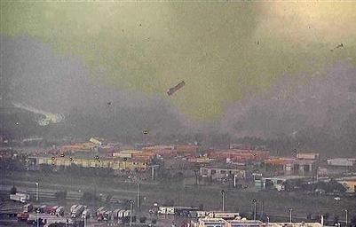
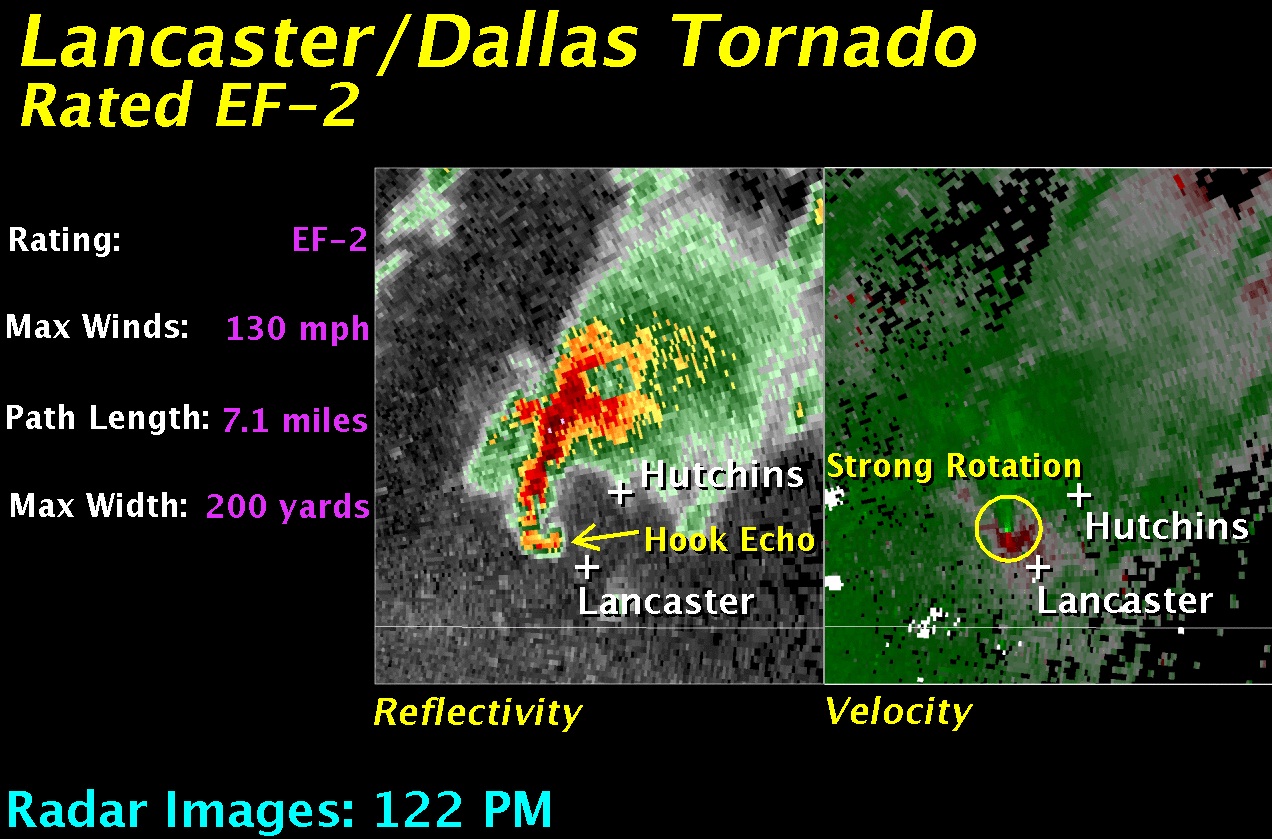
Here are a couple of the many breath-taking photos/videos captured yesterday by storm chasers and those affected:


Unfortunately the severe weather threat didn’t end there. More tornadoes were reported in the Upper Mississippi Valley on Sunday associated with the same system. As the system will race east on Monday, tornado probabilities are greatly reduced across the eastern half of the country however, severe thunderstorms are certainly not out of the question as cold air clashes with the warm air situated ahead of the system.
Elsewhere in Weather News is written by Matt