Summer is Pushing Into Southern Manitoba

The beautiful conditions we’ve had over the past while will take a slight break today, with notably summer-like weather pushing over the Red River Valley. With the Red River and Assiniboine River rapidly rising, how much rain will we see?

A low pressure system currently in Eastern Montana continues to push warm air northwards through the Dakotas towards Southern Manitoba. This warm air brought thunderstorms to Eastern Montana and the Dakotas overnight, and as they have pushed northwards, they have lifted up over the warm front and transitioned to elevated convection that, while weakened, is producing an area of rain that is pushing into our area.

As this precipitation continues to move northwards, away from the warm front, it will weaken as it looses it’s precipitation generating support. The rain that currently resides over the international border will slowly push north, and could give a few light showers to Winnipeg late this morning before it peters out. The main weather that will impact us is currently developing over southeastern Saskatchewan and Southwest Manitoba.


This area of rain visible on the southern edge of the RADAR image will continue to blossom as the low strengthens and overall lift in the area intensifies. This will then begin to track east-northeast later today and spread an area of rain across Southern Manitoba, including the RRV. The models are having some difficulties determining how much precipitation this will produce, which is to be expected, however their tracks for the precipitation are beginning to agree.
GEMLAM

GEM-GLB

GFS

NAM

These models are all from their respectice 06Z runs, except the GEM-GLB which is the 00Z run, showing the precipitation accumulation from 00Z – 06Z tonight. The NAM is a big lighter on the precipitation, but other than that, they all agree (more or less) on location and intensity of the rain. So what will happen?

The precipitation accumulation will vary significantly depending on the amount of embedded convection that manages to develop. Current indications are that after a few showers late this morning, rain will begin to push across the Red River Valley late this afternoon or early this evening. The rain should end over the Southern RRV overnight as the low pulls further north and shifts the precipitation north as well. In Winnipeg, the rain should end sometime early tomororw morning; likely before 8 AM. Total rainfall amounts are difficult to pin down, as it will be directly proportional to the amount of convection that develops, but I would put my money on a general area of 5-10 mm (1/5 – 2/5”). If any significant convection should develop, some areas could potentially see up to 15mm of rain (~ 1/2”).

Once this precipitation clears out, the rest of the weekend will remain a little unsettled. The warm front maintains its position across ND, which will result in the chance of rain over the RRV as convection rides up over the warm front into Southern MB. Next week looks quite nice, however, with mostly sunny skies and temperatures in the low-to-mid teens. How all this precipitation will affect the river levels remains to be seen, however any accumulating precipitation has people concerned with the extremely high river levels that already are impacting the RRV. For more flood information, Rob over at Rob’s Blog has put together a nice collection of flood links.
Rainy Day on Tap for Winnipeg

Winnipeg will see a few showers this morning develop into a rainy afternoon before it all turns to wet snow this evening as the first “summer-y” system of the year pushes through Southern Manitoba.


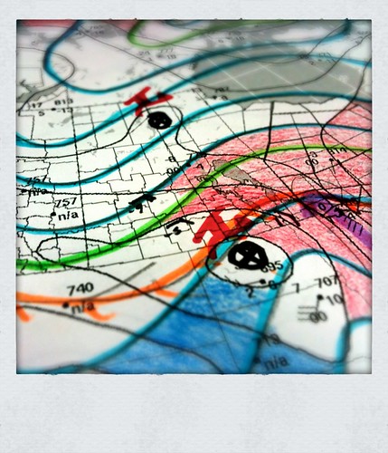
Hand-analysis of the 925mb Height/Thermal Field for 12Z March 20

A very summer-y low is passing through North Dakota this morning, with a warm front draped west-to-east across much of the state, just south of the international border, before it dives south through Iowa. This system has brought with it copious amounts of warm air and is the first real summer-like system of the year.

East of the warm front, in Iowa, a complex of thunderstorms are moving across the state, supported by a 60 kt 850mb jet riding over the surface warm front, bringing with it moist air with Θw values near 20°C. This 60 kt LLJ then arcs north and pushes into Northwestern Ontario. As can be seen by the red shading in the analysis I have done this morning, warmer air is being pushed up through much of Southern Manitoba, including the RRV, Interlake and Parkland regions of west-central Manitoba. With the surface warm front just south of the border and plenty of warm air overrunning it, this has brought a mix of precipitation for areas in Southwestern Manitoba across the Trans-Canada highway into the Whiteshell and north.


1.5km CAPPI Radar Reflectivities

Pilot Mound, Morden, Steinbach and Sprague should escape most of the precipitation until later today. Being so close to the warm front, the precipitation is actually developing north of them where the air aloft that is being lifted is saturating. For those areas, expect a cloudy day with drizzle likely and if the wind manages to calm a bit (say to 15 km/h or less) fog patches are certainly possible. By later this afternoon, rain should move into the area, though with accumulations of about 5mm. For Portage la Prairie, Winnipeg, Dugald, Selkirk/Gimli and the Whiteshell, showers seen this morning will continue to develop and intensify to an area of rain by this afternoon. Expect to see about 5-10mm of rain before switching over to wet snow this evening. Do not be surprised to see a few snowflakes today, though; as it is quite likely for there to be embedded convection in the rain bands, areas of heavier precipitation may be able to produce rain mixed with snow as the shallow warm pool is unable to completely melt all the precipitation.


12Z 20 March 2011 GEM-REG 12h QPF Accumulation valid 00Z March 21 2011

Further west, over the higher terrain, the precipitation will predominantly be snow. Dauphin/St. Rose/Minnedosa are under a heavy snowfall warning as 10-15cm of snow are expected by this evening. Fortunately, as this weather system is driven primarily by warm air, the precipitation should end quite quickly as the low pulls out of our area this evening.

All in all, it’s quite a good day to stay inside with a hot drink and read a book. A little bit of everything will be seen through the afternoon, and unless you’re a big fan of having a new “Rally Inspired” paint job on your car, it’s best to stay off the messy, messy roads.

The next significant weather system will pass through on Tuesday, and this system will receive plenty of attention as it develops as it has the potential to produce significant amounts of snow/rain, and could add uncomfortable amounts of water into the Assiniboine/Red River drainage basins. I’ll post some more information about that system on Monday when things are a little clearer.

Miserable Weather on Tap

Don’t let the bits of sun and relatively warm temperatures fool you; tonight is going to be downright awful.

A complex double-barreled low pressure system (a term used when two separate lows are moving together as one entity) is moving out of Saskatchewan and Montana into Southern Manitoba this morning.  This system has brought a mix of precipitation into Southern Manitoba this morning, including freezing rain over western areas and heavy snow in the Interlake.  Numerous warnings have been issued across the region for weather happening now or expected to happen this evening.

The risk of freezing rain will persist through much of Southern Manitoba for an hour or two longer before temperatures will be warm enough that any precipitation will simply fall as rain.  Even though little precipitation has fallen over the Red River Valley this morning, Manitoba Highways is reporting that many sections of Highway 75 and Highway 1 heading west of Winnipeg are partly iced cover due to the slight melt and re-freeze yesterday afternoon.  As temperatures will just barely get over 0°C today, there may be portions of highways that are still quite slippery throughout the day.

Tonight
Perhaps the biggest impact from this storm will occur tonight over the Red River Valley.  As the low passes to the east, cold air will plummet down the backside of the system through the RRV.

 
24hr Accumulated QPF valid 12Z Saturday March 12, from the 00Z run of the GEM-LAM REG Model 

As the system passes, an intense band of wrap-around precipitation will move into the RRV, bringing heavy snow to Winnipeg by 6 or 7PM tonight.  Along with this heavy snow, this system will bring significant winds as well.


Surface Winds valid 06Z Saturday March 12, from the 06Z run of the GEM-LAM REG Model 

Sustained winds of 50-60 km/h with gusts potentially as high as 90 km/h will blast cold air into the RRV, which will plummet the temperature from 0°C or +1°C down to approximately -14°C or -15°C over the span of a few hours.  This will rapidly freeze any standing water which will very likely create extremely slick roads tonight.  And last but not least, these winds, combined with the heavy snow, will very likely produce blizzard conditions through a good portion of the night.

The weather conditions will deteriorate extremely quickly this evening to become a significant winter storm.  Anyone who has plans to travel in the Red River Valley tonight should keep updated on warnings, forecasts (or for a smartphone), the RADAR, and highway conditions to be able to make safe, educated travel plans.  Good satellite imagery to track this system can be found here at the U of M.

Snow on the Way

A significant storm system is currently developing in Montana this morning that will push it’s way eastwards across the Northern Plains of the United States and into Northwestern Ontario by Thursday morning.

m.jpg

Snow will push into Saskatchewan today and a snow band will develop aligned somewhere between Shaunovan and Kamsack, as shown in the above model image. There is a slight chance that some of these sites will see warning-level amounts of snow, however it currently looks like the possibility of that is borderline. This band of snow will then consolidate and push into Central Manitoba, while a second impulse brings an area of lift into Southeastern Saskatchewan and Southern Manitoba.

m.jpg

This second band of snow will move eastwards through Southern Manitoba, giving most areas somewhere between 5-10cm of snow. Brisk northerly winds will push into the Red River Valley on the backside of the low as it moves into Northwestern Ontario, and with fresh snow, significant blowing snow will exist in any open areas inside the valley. Based on this projection, the snow would begin in Winnipeg late Thursday morning and last until sometime Friday morning, with the heaviest snow and worst conditions coming by late Thursday afternoon. Significant blowing snow would most likely occur during the evening and overnight period, which will be important to take into account for anybody planning to travel on Thursday evening/night, especially through the southern Red River Valley.

At least, that is how this system should evolve. The jury is still out on what will actually happen. The last 5 runs of the GEM-REG model have all produced drastically different results. The GFS and NAM offer little consensus on where the heaviest snow will be, the UKMET shows similarities to the 00Z GEM-REG run (from which I’ve gotten these images), and ensemble models show little confidence in the track and evolution of this system. Why is this? One look at the Water Vapour imagery shows the problem:

m.jpg

The two +’s in this image are the two main vorticity centers for this incoming system, and the yellow arrows depict their rough paths given the streams they are each in, respectively. This system is a somewhat unique scenario, wherein the two “streams” of air are close together, and are moving in sync. Typically, the reason this is a problem is because the models can have a hard time dealing with the energy distribution between the two streams. We have seen many times in the past where model solutions flip flop back and forth and back and forth, even when the event is close (less than 36 hours away) where the model error could be attributed to the complex dynamics that occur when this situation occurs.

So if we don’t actually know what’s going to happen, what’s going to happen?  Odds are that the RRV will get snow on Thursday.  I’ll go on record saying we’ll get at least 3-4 cm.  In a worst case scenario, a line from Pilot Mound to Winnipeg could get as much as 10-15 cm, however I think that’s quite unlikely.  If we get fresh snow in the RRV, there will be blowing snow Thursday night as the winds pick up to 50G70 km/h out of the north.  And sadly, our wonderful warm spell is going to come to an end this week, with temperatures plummeting to -20°C by Friday morning.

I’ll keep the comments of this post updated as the system develops and try to narrow down the impact it will have on Southern Manitoba.  Stay tuned!