Elsewhere in Weather News: May 11th, 2013

Cyclone Duo in Indian Ocean

Two separate cyclones formed in the Indian Ocean this week and will continue to intensify and organize over the weekend. A low shear environment combined with warm sea surface temperatures of around 30°C, were key factors in the formation of these two cyclones.
The first cyclone, located south of the equator, is named Jamala. This cyclone is headed west and is only expected to intensify to a category one hurricane for a short amount of time before weakening to a tropical storm again. Despite reaching category one and heading west towards land, Jamala is not expected to affect Madagascar or any parts of eastern Africa as models show it weakening to almost nothing before reaching the coast.

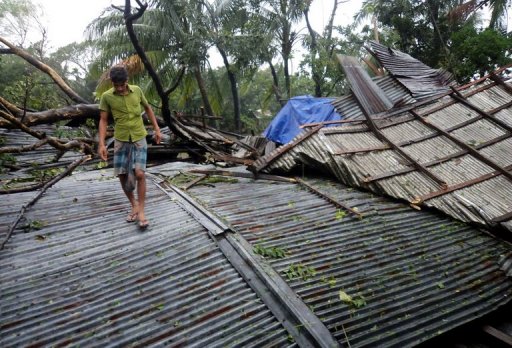
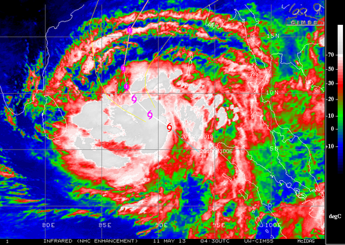
The second cyclone, cyclone 01B located north of the equator, is more of a concern to Bangladesh and surrounding countries. This cyclone has the potential to cause substantial damage to Bangladesh as land is prone to flooding there. Storm surge will likely be an issue, depending on the strength of the hurricane when it makes landfall. As of Friday evening, 01B had estimated maximum surface winds near the 95km/h mark but was expected to increase in strength as it moved north, towards Bangladesh. Landfall is still a ways away, but its stronger outer bands are expected to arrive near the Myanmar and Bangladesh shores early Tuesday.

Cyclone 01B

Enhanced infrared image of tropical cyclone 01B Friday night. (Source: CIMSS/NHC)

The Indian Ocean cyclone season is most active from the beginning of spring to early winter but it is possible to have cyclones form throughout the year.

Elsewhere in Weather News: March 23rd, 2013

Damaging Tornadoes Touch Down Across the World

Tornadic activity was experienced across the globe this past week, affecting countries from Bangladesh to Australia and even China.

Australian tornado

Capture of the Doppler Radar velocity at the time of the tornado (area of dark blue vs. red). (Source: BoM/ @vicstormchasers)

In Australia on March 21st , at least two powerful tornadoes touched down on the border of Victoria and New South Wales, ripping through more than a half-dozen towns lying along the Murray River. The strongest twister, with an estimated F2 rating on the Fujita scale, caused major damage to the towns it swept through – tearing roofs off their structures, throwing cars around and snapping power lines. In total, 20 people were injured and two had to be airlifted to hospital. Thankfully no deaths were associated with this tornado outbreak. A deep low pressure system responsible for spawning these tornadoes lay just off Tasmanian coast with a cold front stretching up into Australia.

Video of the Australian tornado dangerously close up. Power flashes and debris can clearly be seen flying through the air. (Source: Daniel Clarke)

The tornado that touched down in Bangladesh on Friday, March 22nd also caused a fair amount of damage to a few rural eastern Bangladesh towns. The twister was on the ground for about 15 minutes but it is not yet known what the strength of the tornado was estimated to be. At least 100 injuries and 20 deaths were reported as a result of this tornado.

The people of Bangladesh are more susceptible to injury and death from tornadoes since finding a safe haven from them is not as easy as heading down to a basement to take cover. Most houses in the area are built out of mud and don’t have a sturdy structure, making it difficult to escape when residents find themselves in the path of a twister. Tornadoes are common in Bangladesh from March to late April before they transition into the monsoon season.

Guangdong, a southern province of China, was also in the crosshairs of severe weather this week. A supercell produced egg size hail accompanied with a tornado that made its way through the city of Dongguan (pop. 400,000). Significant damage occurred – many buildings collapsed and the storm even overturned a ferry offshore. These Chinese storms were the deadliest storms of the week, accounting for 24 deaths and over 200 injuries.

China egg-size hail

Hail the size of eggs covers the ground in Dongguan, China. (Souce: I.B. Times)

Elsewhere in Weather News: October 12th, 2012

Tropical Storm Hits Bangladesh

A surprisingly strong tropical storm impacted southern Bangladesh on Wednesday and Thursday of this week. According to the India Meteorological Department the storm was a depression, which would give it maximum sustained wind speeds of 52km/h. Forecasters did not believe it would have a significant impact when it hit land, but in its aftermath there have been at least 26 deaths with many people still missing.

Tropical Storm damage in Bhola

Some of the destruction in Bhola is seen on Thursday. The death toll is expected to rise further (AFP/File, Str)

Strong winds from the tropical storm damaged houses and uprooted trees in coastal portions of Bangladesh. Crops were also severely damaged in the storm and some fisherman are feared lost at sea. Many fisherman suggested that poor forecasting downplayed the storm, which didn’t make it clear that they should stay on land.

Bangladesh is a relatively small, but densely populated country (estimated population is greater than 160,000,000) that is located in the delta of the Ganges river. The country’s low-lying coastal location makes it particularly vulnerable to natural disasters, including floods, tropical cyclones, and severe thunderstorms.

Sources:
http://www.ndtv.com/article/world/bangladesh-storm-toll-rises-to-26-scores-missing-278938
http://www.cnn.com/2012/10/11/world/asia/bangladesh-tropical-storm/index.html