A Very May Long Weekend Ahead

After a brief heat wave that brought deadly fires to parts of southeast Manitoba, things will shift to the polar opposite for the long weekend.

ECMWF 24-hour Precipitation Accumulation valid 12Z Saturday May 17, 2025
A swath of accumulating rain will fall across southern Manitoba on Friday with a further 5 to 20 mm across the region.

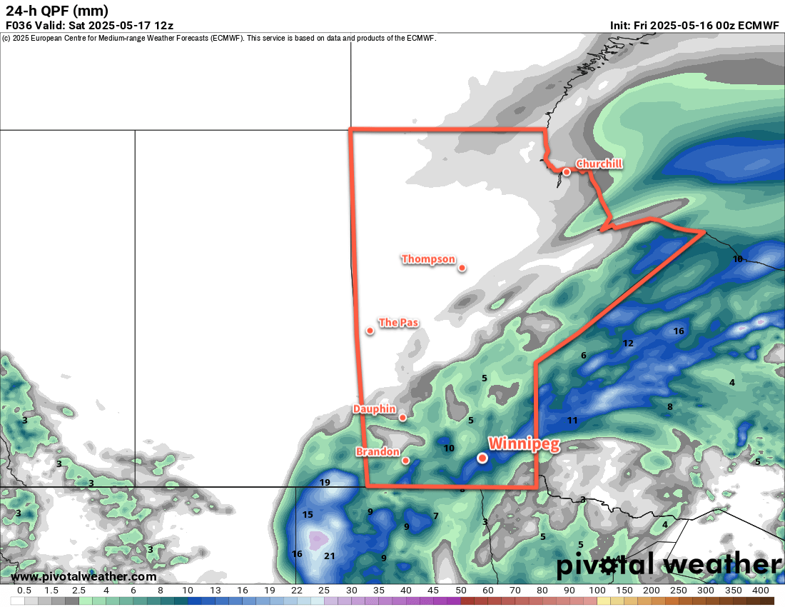
There’s no beating around the bush, it’ll be a miserable day in Winnipeg today. As a potent low pressure system meanders through North Dakota and Minnesota, it will continue to wrap rain into the province while driving a cold front south. It will be a rainy day in Winnipeg today with strong northerly winds developing. Temperatures will fall into the mid-single digits this afternoon as those winds gust as high as 70 to 80 km/h.

Rainfall totals will vary across the Red River Valley, but accumulations will broadly fall into the 10 to 20 mm range with localized pockets of higher and lower accumulations. The main swath of rain will stretch from east of the south basin of Lake Winnipeg southwest through the Red River Valley. The rain will gradually taper off on Friday night as temperatures head down to a low near +2 or +3 °C.

Saturday will be a cold May day with northerly winds up to 40 gusting 60 km/h and a high temperature that struggles to climb into the 5 to 10 °C range. Skies will stay cloudy through the day. Temperatures will drop into the 0 to 5 °C range on Saturday night under cloudy skies. A ridge of high pressure building into the region will finally bring an end to those moderate northerly winds.

Sunday will bring more cloud cover to the region, but sunshine may poke through later in the day. Temperatures will climb to around 10 °C with east winds around 20 km/h. Skies will clear out for Sunday night with a low in the 0 to 5 °C range.

A Note on Smoke

Over the coming days (and weeks?) wildfire smoke will be an occasional concern for the region. Multiple large fires are now burning in southeast Manitoba and northwest Ontario, and their smoke plumes will move towards the region in any easterly or northeasterly wind. That said, it will be complicated to forecast for as the relative closeness of the fires means that depending on the conditions the plumes may be widespread in coverage or they may be narrow bands that stretch downwind of the fire.

Complicating things more will be the need to wait and see how the fires respond to this weekend’s rain and cooler temperatures.

All that to say that wildfire smoke may be a concern at times in the weeks ahead, if not for much of the summer. Moreover, these fires are ripping through cottage country, likely impacting someone you know.

The best thing that could happen is a stretch of cooler weather with frequent rain; we’ll see what happens in the weeks ahead.

Long Range Outlook

Heading into the start of next week, it looks like temperatures will gradually climb back towards seasonal values with mainly sunny skies. At this point it doesn’t look like there will be much chance for precipitation through the week.

Today’s seasonal daytime high in Winnipeg is 20 °C while the seasonal overnight low is 5 °C.

Seasonably Cool Weather Ahead This Week

Temperatures will stay seasonably cool this week in Winnipeg as a couple glancing systems bring chances of light snow.

RPDS 2m Temperature Forecast valid 18Z Thursday April 3, 2025
Seasonal temperatures will build into Winnipeg by Thursday, but a weak cold front will sweep through on Thursday evening.

After a cool start to the morning, breezy southeast winds develop as a warm front pushes north towards southern Manitoba. Temperatures will climb to a high near +2 °C this afternoon with southeast winds of 30–40 km/h gusting up to around 50 km/h. Skies will cloud over through the afternoon; this cloud cover will stick around into the night with a chance of flurries as the warm front moves through. Temperatures will dip down into the -5 to 0 °C range with southeast winds continuing near 20 km/h.

Wednesday will bring cloudy skies to the region as a strong low pressure system moves from the American Plains towards Lake Superior. Temperatures will climb to a high near +3 °C in Winnipeg with easterly winds near 20 km/h swinging around to the northwest through the day. There is a chance of light snow, but it will be contingent on the broader area of snow associated with the low to the south backing northwest all the way through the Red River Valley to Winnipeg. This is an uncertain proposition at this point, and even if the snow does make it this far north, accumulations should be minimal.

Temperatures will dip to the cold side of freezing on Wednesday night with skies staying cloudy.

The sun should appear again later Thursday as the low pressure system glancing by the region shifts off into eastern Canada. Temperatures should pop up to around 5 °C in the afternoon with northwest winds of 20–30 km/h. More cloud will move in later Thursday evening, though, as a cold front swings into the area from the northwest. Temperatures will dip into the -5 to 0 °C range on Thursday night with a chance of flurries.

Long Range Outlook

The cloud and chance of flurries will linger into Friday with temperatures gradually climbing back to the warm side of freezing. Clearing skies on Friday night coupled with a cooler air mass will likely send temperatures back down to around -10 °C by Saturday morning.

The weekend will bring variable cloudiness and cool weather to the Winnipeg area. Daytime highs will dip down to freezing by Sunday with chilly overnight lows.

Today’s seasonal daytime high in Winnipeg is 5 °C while the seasonal overnight low is -6 °C.

#awm_snow #awm_windy #awm_below_normal_temperatures

Arctic Grip Weakens Over Southern Manitoba

The bitter cold that’s been entrenched in the region for over a week will finally give way with temperatures gradually warming to above-seasonal values.

RDPS 2m Temperature Forecast valid 12Z Wednesday February 19, 2025
Although change is on the way, it will be cold across the southern Prairies on Wednesday morning.

Winnipeg’s weather is in for a change this week as a lobe of the Polar Vortex exits the region. It will weaken substantially over the next couple days, then rapidly shift east out of the country through the second half of the week.

As a result, there will be little change through the first half of the week, and substantial change in the second.

Over the next few days, as the weakened portion of the polar vortex dissipates, temperatures will gradually rise. By Thursday, daytime highs in Winnipeg will increase from near -20 °C to the mid-minus teens. Overnight lows will follow, rising from the -30 to -25 °C range into the minus teens.

A sprawling (and weakening) Arctic high will dominate the surface pattern, bringing sunshine and light west-northwest winds.

Long Range Outlook

While Thursday will mark the beginning of a pattern change, it will become more pronounced to end the week. The remnants of the Polar Vortex will rapidly shunt east, allowing an upper ridge to build into the Prairies from the Pacific. This will push much milder air across the region, sending daytime highs well above seasonal normals.

Daytime highs will climb to near-seasonal values on Friday, then warm closer to 0 °C on the weekend. For areas west of the Red River Valley, above-freezing temperatures are probable; we’ll have to wait to see how much mild air is able to scour into the Red River Valley to see how warm Winnipeg is able to get.

ECMWF 2m Temperature Forecast valid 00Z Sunday February 23, 2025
Much warmer weather will sweep across the Prairies this weekend, with daytime highs climbing to 0 °C or higher for most regions.

The above-seasonal temperatures will continue right through next week.

With this change, the region will shift closer to the storm track. No major systems are expected, but occasional bouts of light snow or even a wintery mix will be possible beginning this weekend and through much of next week.

Today’s seasonal daytime high in Winnipeg is -7 °C while the seasonal overnight low is -18 °C.

#wx_below_seasonal_temperatures #wx_above_seasonal_temperatures
#Winnipeg #MBwx

Cold Weather Ahead

An Arctic ridge strengthening over southern Manitoba will bring bitterly cold weather to the region.

RDPS 2m Temperature Forecast valid 12Z Sunday February 16, 2025
Bitter cold will build into the Prairies this weekend.

The weather this weekend in the Winnipeg area will be influenced by three different weather systems. The first is an Arctic ridge re-strengthening across southern Manitoba, the second is a disturbance that will track across the northern United States, and the third is a low that will drop south out of Nunavut.

The Arctic ridge will bring colder weather to the Winnipeg area. Daytime highs will drop from the -20 to -15 °C range today into the -25 to -20 °C range this weekend. Likewise, overnight lows will dip from the -30 to -25 °C range down into the -35 to -30 °C range. These colder temperatures will combine with winds of 10 to 25 km/h and give wind chill values of -45 to -40 at times.

The other two features will bring cloud cover to the region. The disturbance passing to the south will bring mixed skies to the region today and on Saturday. Skies will clear on Saturday night, then mixed skies will redevelop on Sunday as the Nunavut low drops south.

A few flurries are possible on Sunday as the low passes through, but no accumulating snow is expected.

Long Range Outlook

Next week will bring a major change to the weather pattern in the region, but it will be in the latter half of the week. Temperatures will gradually shift to seasonal values through the first half of the week as the Arctic high in the region slowly drops south into the United States. In the second half of the week, the Polar Vortex will re-focus over the High Arctic while a lobe drops south into the United States. This will allow upper ridging to build east into the Prairies and send Pacific air back into the region.

This will allow temperatures to begin pushing back towards seasonal values by the end of the week, followed by the chance for daytime highs that climb above 0 °C on the weekend.

The above-normal temperature pattern looks like it should hold through the rest of February once it gets established. This may put Winnipeg back on the storm track and give a chance of mixed wintery precipitation from time to time.

The return of warmer weather and longer days will help it feel a lot more spring-like by next weekend!

Today’s seasonal daytime high in Winnipeg is -8 °C while the seasonal overnight low is -18 °C.