Temperatures Climb Back Towards 0°C Again

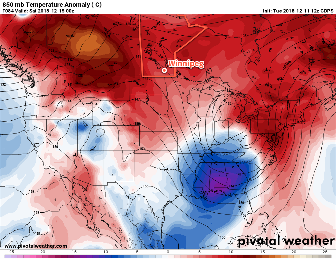
Winnipeg’s temperatures will bounce right back to well above-seasonal values with variable cloudiness to start off the week.

The city will see mixed to partly cloudy skies today and tomorrow as a warmer air mass builds back into the region. Winds will pick up out of the south to 30 gusting 50 km/h midday as temperatures head to a high near -6°C. The city will see partly cloudy to mixed skies. Winds will ease tonight as temperatures head to a low near -8°C. Skies will remain mixed overnight.

Tuesday will see much lighter winds as a trough of low pressure moves through the province. Temperatures in Winnipeg will climb back towards 0°C again with partly cloudy skies. The next approaching low pressure system will strengthen winds back into the 20 to 30 km/h on Tuesday night. More clouds will push through overnight with a slight chance of flurries.

Wednesday will be a mild day with a high near +1°C with mixed to mostly cloudy skies. Winds will be light throughout the day, gradually shifting from southerly to northwesterly as a trough moves through. The wind will pick back up to around 20 to 30 km/h on Wednesday night with temperatures dropping to a low near -6°C.

So other than a chance for a bit of light snow on Tuesday night, Winnipeg will see increasingly mild temperatures with variable cloudiness.

Long Range Outlook

Temperatures will cool slightly for the second half of the work week with fairly cloudy conditions. Snow is possible late Friday into early Saturday as an Alberta Clipper moves through. In the wake of this system, breezy northwesterly winds will usher seasonal temperatures back into the region.

Winnipeg’s seasonal daytime high is currently -11°C while the seasonal overnight low is -20°C.

Slushy Weather Continues As Temperatures Remain Seasonably Mild

Winnipeg’s temperatures will remain well above seasonal right through the weekend and into next week.

Another day of sunny skies is on the way for the city today with temperatures heading back to a high near -1°C again. Winds will become light this morning as a ridge of high pressure moves across the Red River Valley. Temperatures will remain warm tonight with a low near -3°C. Winds will pick up out of the south into the 20 to 30 km/h range this evening as the ridge heads out of the province.

Saturday will bring breezy southerly winds in the 30 to 40 km/h range with temperatures climbing to a high near 0°C. The biggest unknown for the day is exactly how much cloud the city will end up seeing. With another surge of warm air pushing in aloft over top of outflow from a ridge to our southeast, there’s a good chance of a bank of stratus cloud developing Friday night and lifting northwards through the Red River Valley. At the least, the city will likely see mixed skies, if not overcast. Winds will shift to westerly near 30 km/h overnight with a few breaks in the cloud. The city should see a low near -5°C.

Temperatures will remain steady near -5°C on Sunday with west-northwest winds at 30 gusting 50 km/h. The city should see a fair amount of sunshine with just a few clouds lingering past the morning. Cooler temperatures return Sunday night as temperatures dip to a low near -12°C.

Long Range Outlook

Winnipeg will continue to see above-seasonal temperatures with variable cloudiness through the beginning of next week. There’s a slight chance of some showers or flurries mid-week, but other than that it looks dry. Some models show the potential development of an Alberta Clipper that would move through sometime near the end of next week, which could bring significant snowfall, strong winds, and a return to colder conditions. We’ll have to wait and see what happens; for now, enjoy the balmy weather!

Winnipeg’s seasonal daytime high is currently -10°C while the seasonal overnight low is -20°C.

Seasonably Mild Temperatures Continue

Winnipeg will continue to see seasonably mild temperatures with variable cloudiness right through the end of the week.

A weak low pressure system moving into the province will keep skies mostly cloudy in Winnipeg today. Temperatures will be well above seasonal values, though, with the city reaching a high near -1°C. Winds will be breezy, picking up out of the southeast to 30 gusting 50 km/h for the afternoon. The city will likely see a bit of light snow as the low passes through this evening. Winds will ease for the night, leaving cloudy skies and a chance for some fog patches or freezing drizzle. Temperatures will dip to a low near -4°C.

Thursday will see westerly winds near 20 km/h that clear the cloud out of the region. Temperatures will be mild again with a high near -3°C with the winds diminishing in the afternoon. Winnipeg will see a few clouds in the evening followed by temperatures dropping to a low near -7°C.

This map of forecasted 850mb temperature anomalies shows how by the end of the week, almost the entirety of Canada will be underneath a warmer than seasonal air mass.

Friday will bring partly cloudy skies to the city with a high near -2°C. Winds will remain light out of the south through the day. A bit more cloud might end up pushing into the region on Friday night with temperatures dropping to a low near -7°C once again.

Long Range Outlook

Another low pressure system will track across the northern Prairies this weekend, allowing mild Pacific air to continue spreading across the south. As a result, temperatures will continue to remain well above seasonal values right through the weekend with variable cloudiness. The mild temperatures look to continue right through much of next week at this point with no major snowfall events on the horizon.

Winnipeg’s seasonal daytime high is currently -9°C while the seasonal overnight low is -19°C.

Seasonably Mild Temperatures On The Way!

Winnipeg will see very pleasant December weather this week as mild air floods across the region.

Winnipeg will see temperatures climb well above seasonal values as mild air floods eastwards across the Prairies. Today will bring the most sunshine of the next few to the city with nary a cloud in the sky. Temperatures will climb to a high near -6°C with light winds. The city will see increasing cloudiness tonight with temperatures dipping to a low near -11°C.

Tuesday will bring mainly cloudy skies to the city with a high once again near -6°C. Winds will be out of the south at 10 to 20 km/h. A weak upper trough moving through on Tuesday evening will bring a chance for a bit of light snow and usher in slightly milder temperatures. Under mostly cloudy skies Winnipeg will head to a low near -8°C on Tuesday night.

Wednesday will bring more cloud cover to the city, but temperatures will climb to a seasonally balmy -3°C. Winds will be out of the south at 15 to 25 km/h. A stronger trough of low pressure moving through on Wednesday evening will bring another chance for some light snow to the region as temperatures remain steady near -3°C.

Long Range Outlook

The remainder of the week continues to see very mild conditions remain over southern Manitoba. Daytime highs will climb towards 0°C by the end of the week with variable cloudiness through the second half. No major snowfall events are on the horizon.

Winnipeg’s seasonal daytime high is currently -9°C while the seasonal overnight low is -19°C.