A few more days of hot weather are in store before we cool down later this week. Enjoy the heat while it lasts!
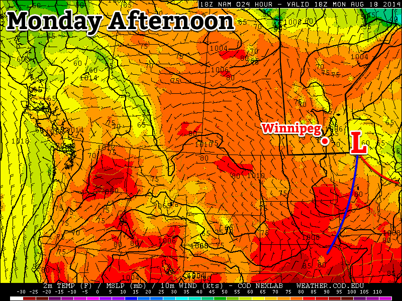
A low pressure system will bring unsettled conditions to south-eastern Manitoba on Monday
Monday
Monday
24°C / 12°C
Mix of sun and cloud with a chance of showers
Today will be a bit unsettled as a large upper-level weather system traverses our region. There will be a chance of showers and risk of thunderstorms in the Red River Valley and south-eastern Manitoba. Any storms that develop will be non-severe, though there is a slight risk of cold core funnel clouds due to the large amount of “spin” with this system. Temperatures will range from the low to mid twenties across southern Manitoba, with the highest readings in western areas.
Tuesday
Tuesday
28°C / 16°C
Mainly Sunny
Tuesday looks to be a very nice day, with temperatures climbing back up into the upper twenties. Skies will be mainly sunny and winds will be light. No precipitation is expected, except for perhaps a stray shower or thunderstorm.
Wednesday
Wednesday
30°C / 18°C
Mainly Sunny
Wednesday looks like another nice day, with temperatures near the 30C mark. There will be a risk of thunderstorms in western Manitoba, but at this point it looks like they should be non-severe. It appears the main risk with any storms that develop will be heavy rain since they’ll be slow-moving due to a weak jet stream overhead.
Long Range
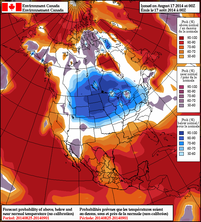
The long range NAEFS model suggests cooler weather will stick around through the end of the month
Unfortunately, it looks like that cool-down I’ve been hinting at is set to take shape later this week. A cold front will probably pass through southern Manitoba on Thursday, dropping temperatures back into the low to mid twenties for late week into the weekend. Models suggest that we’ll see cooler weather – predominately in the low twenties – stick around into next week.
After several fairly nice days in a row, unsettled weather will make it’s return to southern Manitoba as a very powerful upper low moves into the Prairies. The unsettled weather will push through in three distinct phases over the next 3 days, varying from just a few showers to the potential for severe thunderstorms. Without further ado, lets get to it.
Today
We’ll see a very mixed day today as multiple weather features make their way over southern Manitoba. We’ll see a decent chance of some showers this morning as some elevated convection moves through the Red River Valley along the nose of an upper-level jet. We’ll then see a mix of sun and cloud through most of the rest of the day as we climb to a temperature around 24°C. The next bout of unsettled weather will move in this afternoon over SW Manitoba and in the late afternoon/evening for the Red River Valley as two distinct features move into the Red River Valley.
Through the afternoon the 850mb low-level jet (LLJ) will be working it’s way eastwards across Southern Manitoba and, while 700mb temperatures are forecast to sit around 6 or 7°C – a little high to get much convection – the LLJ has had a history of being able to get some heavy showers or weak thunderstorms going despite the marginal instability. This first feature will not likely produce any severe weather.
The second feature moving across southern Manitoba will be a surface trough extending from a low pressure centre in central Saskatchewan southeastwards through southern Manitoba. This trough has the potential to produce severe weather in Southern Manitoba, but the threat has to be considered fairly conditional due to two uncertainties:
Uncertainty in cloud coverage could result in cooler daytime highs than expected; the warmer it gets today the more likely storms will develop.
The warm temperatures at 700mb may be enough to prevent convection from developing; the trough will have fairly strong convergence associated with it, and there may be enough broad, synoptic-scale lift to overcome the warm air aloft.
My gut feeling is that we will see storms develop this afternoon; this trough has had a history of producing thunderstorms the past 3 days in a row. Going with this idea, it’s likely storms will initiate somewhere in SW Manitoba in the mid-to-late afternoon and slowly progress eastwards. The main threats with the storms will be:
Heavy Rain: Precipitable water (PWAT) values are expected to sit around 35–40mm this afternoon thanks to quite a deep layer of moisture moving across the province with this system. That’s a lot of water for these storms to work with. The trough line won’t be moving too quickly and, especially near the western escarpment of the RRV, conditions will be somewhat conducive to the development of quasi-stationary storms. Slow or non-existent storm motion could result in rapid accumulations of 2+” of rain in isolated storms.
Strong Straight-line Winds/Tornadoes: 0–6km bulk shear values will sit around 40kt this afternoon with favourable veering profiles. There’s certainly enough directional shear for storms to develop into supercells, however there may be a lack of backing in the lowest levels to produce enough low-level shear for tornadoes to become a threat. For that reason, I think the most likely wind-related threat would be the potential for strong straight-line winds. This threat would be secondary to the heavy rainfall threat.
Fortunately, with limited CAPE, a high freezing level and significantly weaker winds in the upper atmosphere than on Monday, hail will not likely pose much of a threat today. The showers and thunderstorms should develop this afternoon over SW Manitoba, push through the Red River Valley this evening and lift northwards into the Interlake, flattening out into an area of rain overnight. We’ll see clearing skies overnight here in Winnipeg as we drop to a low of around 14°C.
Saturday & Sunday
Through the weekend we’ll see the passage of the upper low as it moves from central Saskatchewan into NW Ontario. It will begin to move into the region on Saturday and allow things to broadly destabilize in the afternoon which will produce scattered showers and thundershowers. No severe weather is expected. We’ll see a high near 23°C on Saturday and then dip to a low of 12°C overnight with some cloudy periods. On Sunday, we’ll see more cloud than sun and a high near 21°C with scattered showers throughout southern Manitoba. Skies will clear out on Sunday night as we dip to near 10°C.
Next Week
It looks nice for the start of next week with sunshine returning and temperatures climbing back into the mid-to-upper 20’s. At this time it looks like another system will move through late next week bringing another chance of showers and thunderstorms.
The August long weekend will be off to a stormy start today as the threat of severe thunderstorms bears down on the Interlake, Red River Valley and Whiteshell this afternoon.
One of a couple of tornadoes that the incoming system spawned in Saskatchewan yesterday. Photo by @TheMrsCogs.
A very powerful low pressure, responsible for at least two tornadoes in Saskatchewan yesterday, will move into Southern Manitoba today and push a cold front across the province through the day. Very strong dynamics will accompany this system, a stark contrast from the last few systems which have had comparatively strong thermodynamics instead. Despite the lack of strong thermodynamic parameters that are often looked at when diagnosing severe thunderstorm potential, such as CAPE, EHI or LIs, the strong dynamics will present a significant severe weather threat over south-central and southeast Manitoba.
Dynamics are physical, kinematic properties of the atmosphere, such as jets, shear and lift. Thermodynamics are thermal/energetic properties of the atmosphere such as temperatures, humidity and instability.
A band of showers will push into the western Red River Valley early in the afternoon ahead of the upper low. As the afternoon progresses, the upper low will begin to deepen and enhance the destabilization over the Red River Valley. By mid-to-late afternoon, despite the cool temperatures and cloudy skies, there should be rapid development of storms along the cold front. Tornadoes are unlikely, although not impossible, here in Southern Manitoba; that threat should be relegated to the Dakotas where even greater dynamics and substantially better thermodynamics are present. If any tornadoes do form tomorrow, it’s likely that they will be of the short-lived variety and relatively weak. The greatest threat from today’s storm will be extremely heavy rain giving rapid accumulations of 1-2” (25-50mm) given precipitable water values of 40-50mm and large, damaging hail given the cool temperatures aloft.
Day 1 thunderstorm outlook valid 18Z today through 12Z tomorrow morning.
The storms will exit the province overnight, and we’ll have a brief reprieve from precipitation. On Saturday, some showers will wrap down into the RRV on the back side of this system. Amounts will vary across the region, but in general less than 5mm is expected. Temperatures will struggle to climb to even 20°C; daytime highs of only 18 or 19°C are expected. Winds will be breezy from the NW.
This system will clear out Saturday night before nicer weather builds back in. The second half of the long weekend will see increasingly sunny skies and daytime highs near 25°C.