Unstable conditions across southern Manitoba will support areas of showers that move through the region today. The rain will clear out this evening, leaving behind near-seasonal conditions for the weekend.
A stalled frontal boundary slowly collapsing over southern Manitoba will spread showers across the region today. Initially, a band of showers west of the Red River Valley will shift into the region through the morning. As the day progresses, another wave of showers will lift northwards out of the United States as a low pressure system moves from Nebraska towards Minnesota. These two areas of showers will merge over south-central and southeast Manitoba by the evening, then slump southeast through the night.
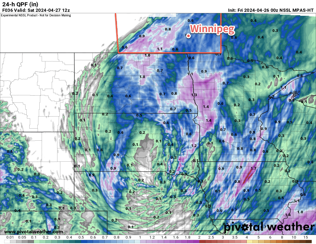
These showers could bring a widespread 10 to 25 mm of rain to many parts of southern Manitoba today, but will quickly weaken heading into the night. WIth the cloud and rain, temperatures will be cooler with highs in the low teens. For those who have found the dry conditions lately irritating, dew points in the mid-single digits will be a welcome relief.
A cold front will push through in the second half of the night, ushering in northerly winds and a cooler air mass. Temperatures will fall to a low in the mid-single digits tonight.
Skies will clear out on Saturday as an area of high pressure moves into southern Manitoba. Temperatures will rebound to a high near 10 °C with northerly winds increasing into the 30–40 km/h range in the morning, then weakening. A ridge of high pressure will bring mainly clear skies on Saturday night with a low dipping to near 0 °C.
On Sunday, another low pressure system will lift towards Minnesota. This will bring increasing cloudiness to southern Manitoba as easterly winds pick up into the 20–30 km/h range. High temperatures will climb back into the low teens on Sunday afternoon.
On Sunday night, more rain will move into southern Manitoba from North Dakota and Minnesota. As the night progresses and temperatures drop, though, the rain may change over to wet snow. Temperatures will drop into the low single digits with light northeast winds on Sunday night.
Long Range Outlook
A rain/snow mix will shift east out of the province on Monday, leaving behind as much as 5 to 15 mm of a sloppy rain/snow mix. It will be a cold April day on Monday with a high temperature in the mid-single digits.
That system will barely have cleared out on Monday before another disturbance moves into the region on Tuesday. This will bring more rain showers to southern Manitoba as temperatures return to seasonal values.
Heading into the latter half of next week, the weather pattern looks to settle down and the region will shift into a seasonal to seasonably mild pattern.
Today’s seasonal daytime high in Winnipeg is 14 °C while the seasonal overnight low is +1 °C.