Cold Weather Continues

The cold weather continues in Winnipeg for much of this week with only a brief respite mid-week of some near-seasonal temperatures. Snow-wise, a weak system moving through today will bring a couple centimetres of fresh snow, but otherwise no significant snowfall is in the forecast.

Today’s weather will be dominated by a weak shortwave disturbance sliding southwards through the province. Light snow will push into the Red River Valley from the northwest this morning and taper off this evening. Accumulations will be relatively low with this snow; for the most part, just 1-2cm is expected to accumulate. As the system begins heading past us this afternoon, gusty northwesterly winds to 20-30km/h will develop, making it feel more like the minus 30’s than the high of -20°C.
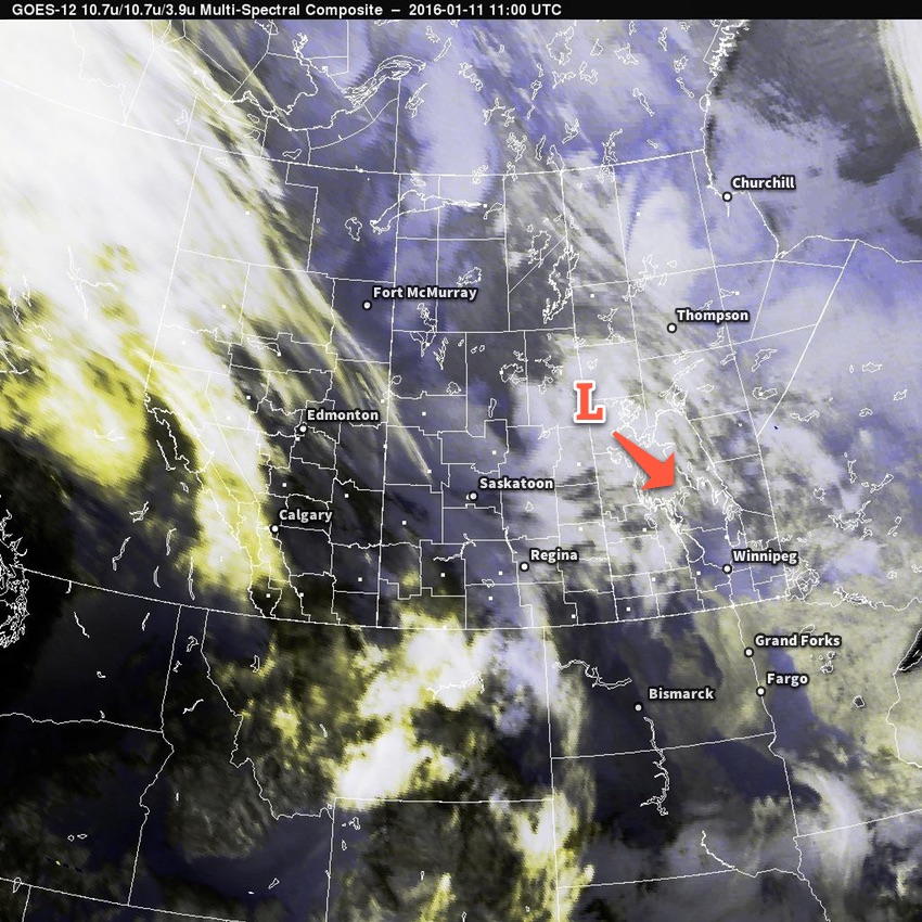
Multi-spectral satellite imagery of approaching low pressure system.
This morning’s satellite imagery reveals the low pressure system that will slump to the southeast and bring light snow to the region today.

Behind this system, another Arctic ridge will build into the southern Prairies, reinforcing the cold air. Here in the Red River Valley, temperatures will dip to around -26°C tonight with wind chills in the -33 to -37 range. In the southwest corner of the province, temperatures could fall as far as -30 to -31°C, which would result in wind chills near or slightly below -40.

Tuesday will be a fairly quiet day over Winnipeg & the Red River Valley with mixed skies and a high near -20°C. Winds will be fairly light.

The next system moving into the Prairies will spread cloud across Southern Manitoba on Tuesday night, somewhat limiting our overnight low to around -24°C.
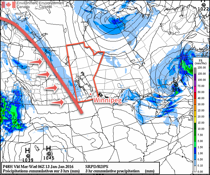
3hr QPF from the RDPS valid overnight Tuesday.
This forecast from the RDPS for Tuesday night shows a broad warm front pushing into Manitoba with an area of light snow ahead of it.

Wednesday is a bit trickier, but either way things pan out, the weather won’t be too significant. The big story will be that near-seasonal temperatures will finally move into the Red River Valley with daytime highs climbing into the -13 to -15°C range. Skies will be mainly cloudy.

Depending on how far east the disturbance moving through the region pushes, we may see some light snow through the day. If it remains to our west, as guidance suggests, it seems probable that we could see some very light flurry activity across the region.

Temperatures will remain comparatively mild on Wednesday night with overnight lows near -20°C.

Colder air is set to return for the second half of the week with another shot of sub-20°C high temperatures likely this weekend.

Welcome Back, Winter

Below-normal temperatures return for the long haul as yet another Arctic air mass settles in over the province. At least we’ll see some sun.

Friday
⇓ -15°C / -22°C
Clearing & windy.

Saturday
-13°C / -24°C
A few clouds.

Sunday
-13°C / -21°C
Mainly sunny.

If I’m really digging for a positive angle for today’s weather, then we’ll go with the fact that it won’t be quite as bad as it looked like it might be. With last night’s system tracking further south than previously expected, significantly less snow has fallen over the Red River Valley and, thanks to that southern track, the winds today won’t be quite as bad as it had looked.

The main story today will be the temperatures and the wind. Our temperature this morning around -10°C will be about as warm as it gets; strong northwesterly winds to 30-40km/h with gusts near 60km/h will usher in very cool air and result in temperatures dropping through the day to around -15°C. Skies will clear fairly early this morning and then we’ll spend the rest of the day under mainly sunny skies. There may be some blowing snow in the Red River Valley today, but the reduced snowfall and winds, coupled with the warmer temperatures of the past few days, should keep its impact fairly minimal. Under clear skies, temperatures will drop to around -22°C tonight.

Tomorrow will bring mostly sunny skies, albeit with a few afternoon clouds, and a high near -13°C. Temperatures will drop to around -22°C again tomorrow night. Sunday will be another sunny, cool day with a high near -13°C and a low of around -21°C.

This cool weather, while not the bone-chilling temperatures we saw in January and February is still quite remarkable. Daytime highs will be nearly 15°C below normal while overnight lows follow suit at around 10-15°C below normal[1].

Below Normal – Get Used to It

While I’d love to say this cold snap is short lived, apparently winter isn’t quite willing to let spring move in yet. While the extreme departure from normal will only last through the weekend, it looks like (for the most part) we’ll see below normal temperatures right through the end of the month.

Below-normal temperatures are forecast through to the end of March for Manitoba.

Temperatures look to warm up to only around 5°C below normal by the middle of next week, but in general don’t expect to see any prolonged springtime warmth until we get into April.


  1. For March 21st, seasonal daytime highs for sit at +1°C and seasonal overnight lows sit at -9°C .  ↩