Elsewhere in Weather News: September 14th, 2013

Historical Flooding in Colorado

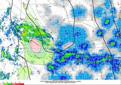
This past week Colorado has been absolutely swamped thanks to moisture streaming up from the Gulf of Mexico, riding up the Rocky Mountains (upslope flow) and then falling as rain. High pressure sliding down from the north in the US Plains as well as an upper-level low to the west drew in the moist air from the southeast. Generally, 850mb dewpoints could be found in the 15°C range and PWAT values around 40mm in Eastern Colorado. Plentiful moisture was in place – a recipe for heavy rains that had the possibility to fall for a long period of time. This became the case for Wednesday evening through Friday morning for Boulder, Colorado and surrounding communities.

850mb moisture transport

Radar with overlay of the 850 moisture transport, notice the vectors all pointing towards the Rockies. Taken Friday 3am. (Source: SPC Mesoanalysis image archive)

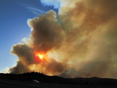
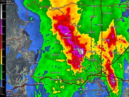
As best described by NWS Boulder, flooding of “biblical” proportions took place is continues as of Friday night. Small creeks easily turned into raging rivers that inundated whole towns and mudslides blocked highways, took out buildings. The death toll is already at four but concerns of more as 172 people are still missing and some communities are literally cut off, with no roads leading in or out of town. Interstate 25 had been closed due to water running over it as well as numerous other highways that had simply been washed away.

The average rainfall per year for Boulder, CO is around 525mm, this means that in a few days Boulder got over half its annual rainfall at 310mm. This easily beats out the old record for rainfall in September (243mm), and average of 43mm (this month; 721% above average September rainfall). Interestingly enough, the area which received all this rainfall was under a moderate to extreme drought as per the Drought Index.

Rainfall estimates

Estimated rainfall from KFTG as of Friday 3am. Notice the dark purples/white; areas above 200mm estimates. Map storm total accumulation. (Source: GRLevel3)

It appears as though Boulder might get a break from the rain today as the upper-level low weakens and moves further east though there is still a slight chance for pop-up (non-severe) storms. Tomorrow will likely bring with it more rain for the region, unfortunately.

Elsewhere in Weather News: June 15th, 2013

Colorado’s Black Forest Fire

Residents of Colorado Springs and surrounding areas have been on high alert this past week because of wildfires in the area that are burning out of control. Currently, there are three large fires burning in Colorado. The largest wildfire of the trio is known as the Black Forest Fire. This fire covers about 60 square kilometers and has destroyed about 400 homes already, as of Friday evening. Unfortunately, two people have also perished from this fire. On Friday thunderstorms moved over the area but although they brought much needed rain, they also had undesired effects such as cloud to ground lightning strikes that potentially sparked up new fires. The Black Forest Fire is around 30 percent contained as of Friday evening so firefighters still have quite a bit of work to do this weekend.

The reason for such extreme wildfire events this spring in Colorado can be associated with drought. The severe drought that was seen throughout the US Plains last year and into this spring has shifted slightly further west. Although areas of the Plains have been mostly relieved of drought from thunderstorm activity this spring, Colorado has continued to experience severe to exceptional drought. The town of Colorado Springs is located under extreme drought which translates into little moisture available for vegetation and in consequence, wildfires are easily sparked.

Black Forest Fire

Plume of smoke from the Black Forest Fire threatens homes in the foreground. (Source:Reuters)

Temperatures are expected to remain quite warm with highs in the upper twenties and even low thirties in the area this weekend, not helping the fire risk. There is also a chance of storms. The longer range doesn’t look promising for drenching rains either as a ridge is expected to redevelop in the southern US Plains mid next week.

Elsewhere in Weather News: June 9th, 2012

Colorado and Wyoming Battered by Storm System

A low pressure system that has brought tornadoes, hail and large amounts of rain to the western half of the United States this week has caused significant damage in Colorado and Wyoming. The warm, moist, air rushing north from the Gulf of Mexico made for a volatile atmosphere Wednesday and Thursday afternoon as it clashed with the Rocky Mountain range.

Piles of hail

A woman walks where bulldozers piled up huge amounts of hail. This picture was even taken the morning following the storm! (Source: The Gazette)

On Wednesday, storms dumped huge amounts of rain and hail in many parts of Colorado and Wyoming, prompting the National Weather Service to issue flash flood warnings in areas where storm cells were nearly stationary. Colorado Springs had a very intense thunderstorm pass through it where over 20cm of hail fell in the area and snow plows had to be used to clear roads and parking lots. Fire and rescue were also kept busy, saving people from submerged cars that had water up to their roofs. On Thursday morning residents there were surprised to see what one man described as a “scene that you’d only see in the winter”. A little further north, on Wednesday, was where most of the tornadic action was happening. In total five tornadoes were sighted touching down in the northern tier of Colorado, however only minor damage occurred and thankfully no injuries were reported. One tornado, reported as a landspout, even scooted to the north of Denver’s international airport, causing a scare to many passengers, but no damage was done to aircraft.

Precipitation map - Colorado Springs

Map of the rain the fell (inches) in Colorado Springs, CO. (Source: CoCoRaHS)

The harsh weather didn’t end there however. On Thursday the 7th, another round struck the same area spawning more tornadoes, dropping huge hailstones and more significant rainfall. On Thursday the heaviest of the rain occurred in extreme northern Colorado and south-eastern Wyoming, where it was greatly appreciated to help combat a moderate drought and wildfires present in the region. In total, the SPC received another 10 tornado reports, some being more serious, ranging from roofs being blown off to windows being blown out. Only one non life-threatening injury was reported with that round of tornadoes thanks to the great work of the National Weather Service who provided early warning.

Wyoming tornado

A large funnel 100km north of Cheyenne, WY. (Source: Andrew Kniss)

As the trough spawning the severe weather shifts west, the region will experience cooler weather, thus, giving way to a stable atmosphere and calmer weather.

This system that that the western half of the United States experienced this week is expected to spawn severe thunderstorms in North Dakota and in southern Manitoba today.

Elsewhere in Weather News: May 19th, 2012

Strong Winds, Wildfires Rage On

South-eastern Manitoba has seen its fair share of fires burning this spring but it wasn’t comparable to the conditions experienced this past week in Arizona and Colorado where wildfires are burning out of control across the states. Fanned by very strong southwesterly winds associated with a ridge of high pressure that is strengthening over the west coast, the fires quickly grew out of control in Arizona. Wind gusts of 80km/h were recorded in the area which easily spread the flames and expanded the fire by blowing embers, making it nearly impossible for firefighters to contain the blazes. In addition to the strong winds, both states have been impacted by severe droughts this month; especially Arizona where soil moisture content is bone dry.

Fire map

Map showing in red where the largest fires are. (Map provided by Google Maps.)

As of Friday morning, one dangerous fire was burning in north-eastern Colorado; a couple in the Tonto National Forest just north-east of Phoenix, Arizona; and other smaller fires had flared up in New Mexico and Utah.

As for the Colorado fire, conditions will improve slightly as thundershowers are in the forecast and will bring rain however cloud-to-ground lightning from the storm could potentially spark more fires. The Colorado fire was 11% contained as of Friday afternoon; it consumed more than seven thousand acres and has forced a couple dozen people out of their homes.

Colorado wildfire

Image of the large Colorado fire burning just west of Fort Collins. (Source: Denver Post)

For the Arizona fire it’s a different story though – as a big ridge builds over the region, relative humidity will continue to drop dramatically, reaching values in the low teens to single digits. This, combined with extremely hot temperatures of around 40°C, will surely cause hardship and less than ideal conditions for firefighters as they work feverishly to battle the flames. The Arizona fire was 5% contained and 80 homeowners were on alert to get ready to leave on Friday afternoon. With the tinder-dry conditions persisting in the area for the next couple of days, residents must pay attention to every slight fire danger they may pose during everyday activities –whether it’s having a barbeque or using their ATV in the wilderness.

Arizona wildfire

Cloud of smoke coming from the couple wildfires in Arizona’s Tonto National Forest. (Source: MSNBC)