Elsewhere in Weather News: November 2nd, 2013

Strong Mid-Latitude Cyclone Whips Europe

An extremely powerful mid-latitude cyclone sitting off the coast of Scotland affected parts of Europe such as England, Denmark and Germany early last week. Winds were the main threat associated with this storm as gusts reached just below 200km/h in Denmark. The reason why this storm was not classified as a hurricane, even though it had hurricane strength winds, is because hurricanes have a warm core and do not have well defined fronts like low pressures systems do. Here, a mid latitude cyclone was the case as fronts were well defined and other various characteristics did not match one of a hurricane.


A house in Germany was completely destroyed by winds gusting over 100km/h this past week. (Souce: Christiane Boose)

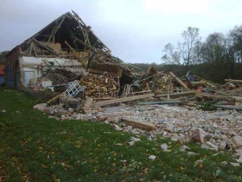
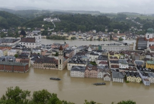
In total, 15 people died from this storm, most due to falling trees. This storm left about 500,000 people without power as trees snapped like twigs and fell on power lines. Off France’s coast waves as high as 5-6m were reported and about 1,300 flights were grounded because of the strong winds.

These very powerful low pressure systems are not unheard of for Europe, though storms with gusts of this intensity do not occur on a yearly basis. This low has since moved off into Russia and is no longer affecting the region. Gusty conditions are expected to return to the UK this weekend as an active pattern, which is not out of the usual for this time of the year, continues.

In other weather news, an unusually strong typhoon (Krosa) has spun up and as of Friday night was of category three intensity. Conditions are not particularly favourable for further development in the South China Sea and the typhoon should gradually weaken as it drifts towards Vietnam.

Elsewhere in Weather News: June 8th, 2013

Severe Flooding in Europe

Major flooding has swept across central parts of Europe where Slovakia, Germany and the Czech Republic have all experienced crippling flooding this past week due to extreme rainfall. Amounts of 75mm were widespread across that part of the continent, and near the Alps, significantly higher amounts of precipitation were observed (some as snowfall at higher elevations). A few reports of 150-200cm of snow were recorded in Austria and Germany at high elevations.

Flooding

Severe flooding in Passau, Germany where the Danube easily overflowed its banks. (Source: AFP)

Rivers such as the Danube and Elbe have reached levels last attained 11 years ago and are threatening or have already breached sandbag dikes in some areas. Over 300,000 sandbags and counting have been prepared and put in place to prevent both rivers from overflowing their banks. The threat of a flood has forced residents out of their homes – as many as 40,000 people have been forced to move away from the nearby dikes and up to higher ground. The flooding upstream also has residents in Hungary, especially Budapest, worried as the Danube River has not crested yet but is expected to reach its peak later this weekend. Dikes there are expected to hold if the current crest projection is correct; it is believed the crest will be about a foot below maximum capacity.

Unfortunately 17 people have already lost their lives to the rapidly rising floodwaters and damage estimates top the 15 billion mark. Crop damage is widespread across Germany where over 250,000 hectares have been flooded out.

The forecast for central Europe calls for some rain on Sunday, associated with a trough but these showers will be nothing near as significant as what was experienced last week.

Elsewhere in Weather News: March 30th, 2013

Europe Battles Cold

This past month it has not only been Southern Manitoba dealing with pesky cold Arctic air lingering around while the spring thaw should be starting up, most of Europe has also been under significantly below normal temperatures for the month of March. What has been bringing such cold weather can be attributed mostly to the same reason why we’ve been getting such cold; a negative NAO (North Atlantic Oscillation) pattern. This is cause for Scandanavian highs staying put and bringing down some unseasonably cold air from the north-east in Europe’s case.

NAO

Graph of the NAO showing values of below zero for the whole month of March. (Source: NCEP)

Germany has had the worst of the cold in Europe with their average March temperature 4°C below average – the coldest ever since record keeping started in 1883. Other parts of Europe were generally 3°C below average for March. To add to the cold temperatures, Europe has been faced with a few significant snowstorms this month, such as last week’s snowstorm that caused hundreds of flight cancellations and even the closure of Frankfurt’s International Airport. The reason for these significant snow events this late in the season can be attributed to a low pressure system drawing in moist air from the North Mediterranean. This, when combined with the stationary Siberian high feeding cold air into the northern half of the low, makes for ideal snowy conditions.

Low pressure system, Europe

Low pressure system making it’s way across Europe and bringing with it snow. Heavy snow in areas outlined in purple, thanks to cold air being brought down by the Scandanavian high.

The Scandanavian high looks to stay put over the region for just a little less than another week, however, with the NAO trending upwards and with the sun getting stronger every day (we are now at the equivalent of a September sun), this means that warmer temperatures are on the horizon for most of Europe for the second week of April.

Elsewhere in Weather News: August 18th, 2012

A Look Worldwide into July, 2012

As reported on Friday, Winnipeg is shaping up to be one of the hottest years since record-keeping began 139 years ago, with July closing out as the 5th hottest month on record for the city. Wondering how the rest of the world faired this past month?

Interestingly, most of the Northern Hemisphere has also experienced extreme temperature anomalies this year. According to the National Climactic Data Center (NCDC), the Northern Hemisphere land surface temperatures this July were 1.19°C above the average, making July 2012 the warmest July in the Northern Hemisphere ever. This year has experienced no shortage of record breaking temps in the Northern Hemisphere – it is now the fourth month in a row that surface land temperature records in this hemisphere have been broken. Canada and the United States have contributed greatly to the record-shattering numbers these past four months but the heat wasn’t confined to North America. South-Eastern Europe has seen conditions almost identical to ours this summer – very dry with record-setting warmth; while Serbia and Bulgaria have been impacted with severe drought this growing season, resulting in severe crop losses. Bulgaria has lost around 10% of its wheat crops due to the sizzling heat, and their maize crops have decimated to the point whereby getting half their average crop will have to suffice. The only countries in the world to have shown significant temperatures below normal this July were Australia, Argentina and parts of the Antarctic.

Temperature anomalies July 2012

July temperature anomalies and circled, areas talked about in EIWN. (Source: NASA Earth Observatory)

Precipitation anomalies July 2012

Precipitation anomalies for July 2012 and circled in red is where severe drought is occurring in South-Eastern Europe. (Source: NCDC)

Arctic Melting

In some areas of the Arctic, July temperatures have exceeded 6°C above average. Arctic ice is continuing to melt at a disturbing rate. The expanse of the Arctic sea’s ice coverage is now at its lowest ever at this time of the year, having dropped even further than measurements from the record-setting year, 2007. In July, almost all of Greenland’s entire ice sheet experienced melting – a “rare event” as described by the National Snow & Ice Data Center (NSIDC). To put things into perspective, sea ice used to reach seven million square kilometers in the 1990s at their minimum, while it has only surpassed five million square kilometers once in the past six years (showing a 29% decrease of minimum sea ice extent in the last few decades). This has lead scientists, like Walt Meier, a scientist at NSIDC, to believe that sea ice could potentially be eliminated by the year 2030 if melting continues at this pace. If this does happen, the ice melt could trigger a domino effect: raising ocean levels, releasing methane from frozen soils, and so on.

Sea ice extent graph

Sea ice extent by year. (Source: NSIDC)