Warm, Windy Weekend

Southern Manitoba will continue to see a gradual improvement temperature-wise, and even start creeping into the above normal temperature range this weekend as a southerly flow kicks in. The one caveat is that winds will be fairly strong on Saturday and Sunday, so hold onto your hats!

Tight gradient between the low over the northern MB/SK border and high pressure to our southeast will make for warm, gusty conditions on Saturday.
Friday
10°C / 2°C
Becoming mainly sunny late in the morning

High pressure to the southeast will make for calm conditions today, with mostly clear conditions and slightly below seasonal temperatures. Throughout the day the ridge will continue to shift eastward, making way for the next system arriving this weekend. With most of the cloud clearing out by late morning, giving way to sunshine it should turn out to be a fairly nice day with a tinge of chill in the air, as temperatures approach the 10°C mark. By the time Friday night rolls around, strong southerly winds will start to pick up as the next low pressure approaches to our north – a tight gradient between the high to our southeast and the low to our northwest will be in place.

Saturday
14°C / 7°C
Starting off sunny, possible afternoon cloud

Saturday looks to start off with plenty of sunshine but the downside will be the windy conditions. Winds will continue to gust throughout the day but temperatures will manage to climb to the low to mid-teens across Southern Manitoba. With that said, there is a chance for some stratus to move in from North Dakota in the early afternoon which means we might not heat out completely. The low Saturday night will be fairly mild thanks to some cloud in the region keeping things warm as well as the southerly flow staying in place – lows will be well above the freezing mark.

Sunday
15°C / 5°C
Mainly cloudy

By Sunday morning winds will have shifted to the northwest due to a cold front sweeping through the region in the morning. Although winds won’t be as strong as Saturday, they will continue to be gusty behind the cold front. Clouds are expected to linger throughout the day but there won’t be any significant precipitation. The temperatures will remain fairly warm, near average values – low teens are expected. Sunday night the low is will drop to the single digits, however, temperatures won’t drop below freezing.

Long Range

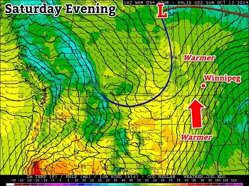
The Climate Prediction Centre as well as a few weather models show temperatures staying above normal for a good part of the beginning of next week with another low pressure system making its way across the Prairies and drawing in warm air ahead of it.

The Cold Front is Coming!

The cold front is coming! The cold front is coming! After a pleasant weekend, things will turn sharply cooler this week as a potent cold front plows through southern Manitoba today.

A cold front will bring sharply cooler weather to southern Manitoba on Monday

Monday

Monday
22°C / 7°C
Mainly cloudy with chance of showers

Today will see a strong cold front sweep through southern Manitoba. The front will move through western Manitoba early in the morning, exiting the province by late afternoon or early evening. There may be a few showers along this cold front, but no significant precipitation is expected. However, temperatures will drop significantly behind the front, and winds will increase as well, marking an end to summery weather, at least for now.

Tuesday

Tuesday
10°C / 4°C
Mainly cloudy with showers

Tuesday will be a nasty day. High temperatures will struggle to reach double-digits and there will be a breezy north wind. To add insult to injury, we may also see some showers throughout the day, just adding to that nasty fall feel. This will be our first taste of fall weather since, well, last fall!

Wednesday

Wednesday
12°C / 2°C
Mix of sun and cloud

Wednesday will be another cool day in southern Manitoba. High temperatures in the low double digits are expected, with a breezy north wind once again.

Long Range

After reading about the gloomy weather above, you’re probably hoping this isn’t it for summer…well, all hope is not lost, at least not yet! Long range models suggest that we may return to a more summery pattern at some point in the second half of September. Let’s hope the long range forecast is correct!

Uneventful and Cooler End to the Work Week

A strong low pressure system located to our south-east, in the Northern US Plains, is expected to bring the Dakotas their first snowfall accumulation for the 2013-2014 winter season but will only clip portions of extreme south-east Manitoba.

US Plains low

Low pressure system affecting Northern Plains depicted here for 4PM CDT today. It will keep us cool and cloudy for most of the afternoon/evening.

Friday

Friday

8°C / 1°C
Becoming overcast early on in the day.

Today, temperatures will be slightly on the cool side. The strong system aforementioned will be drawing in cooler air from the north into southern Manitoba. Models are in agreement that rain and snow will stay out of Winnipeg, though there is a slight chance that regions in extreme south-east Manitoba get some showers Friday evening. Winnipeg can expect to see a high near the 8°C mark with increasing cloudiness throughout the day. In the afternoon and evening winds will be stronger 20km/h gusting to 40km/h coming out of the north. It will be a notably chilly day; our high will be some 7-8°C below normal for this time of year. West of the Red River Valley will be even chillier with highs only expected in the mid-single digits. For Friday night, there is a small chance of frost in Winnipeg but areas more at risk lie to the west of the city.

Saturday

Saturday

10°C / -1°C
Mainly sunny.

Saturday looks to be a nicer day, compared to today; mostly sunny skies combined with slightly higher temperatures around 10°C. The only potential downfall looks to be the wind which will still be fairly strong in the afternoon: 20-30km/h from the north before it dies down in the evening. Saturday night will be a chilly one with high pressure in our region, light winds and clear skies for the most part; Winnipeg has a good chance at seeing some frost.

Sunday & Beyond

Sunday

13°C / 4°C
Mainly sunny, a few stray clouds.

The weekend looks to end on a good note with mainly sunny conditions under more of a westerly flow. Highs in the low to mid-teens can be expected for southern Manitoba. Winnipeg looks to see a return to seasonal temperatures with a high of around 13°C weaker winds than the past few days.

For the beginning of the next work week temperatures appear to stay near normal as high pressure moves in. As the high pressure system moves east, a return flow will likely bring in some warmer, above normal, temperatures to the Red River Valley by Tuesday.

Fall Weather

Fall has officially begun and, rather fittingly, fall weather is in store for the next few days.

High pressure will be in place over much of Manitoba for the first part of the week

High pressure will be in place over Manitoba for the first part of the week

Temperatures for the first few days of this week are expected to be around or slightly below normal. Monday, Tuesday, and Wednesday will all have high temperatures in the low to mid teens (normal high is 16C). Monday will have a cool north wind, but on Tuesday and Wednesday the wind should not be much of a factor. No notable precipitation is expected for the first half of this week as we remain under a surface ridge of high pressure.

Models have been hinting at some warmer weather towards the end of this week into next weekend. As the high pressure system from earlier in the week moves off to the east it appears that a southerly flow will develop over Southern Manitoba, allowing us to see some more above-normal weather before the end of the month.