Dangerous wildfires flared up in the tinder-dry Adelaide region of Southern Australia early this past week, forcing residents to evacuate their homes.
It is not known what started the large bushfires, but weather conditions were the primary factor as to why the wildfires were able to spread so quickly. Long-term drought which has reached severe levels in the region was the first cause for concern that bushfires were possible. This past week’s summer-like weather was what caused the risk to turn into reality as temperatures rose anywhere between the mid-30s to as high as 42.5°C in the region. These temperatures combined with strong, dry (northerly) winds blowing from central Australia was all that was needed to fuel the fires. In total, a few thousand people had to be evacuated and about 40 houses and 12,500 hectares were lost from the bushfires even though nearly 2,000 firefighters battled the flames. The good news is that no severe injuries were reported and firefighters were able to save nearly 1,000 houses in the region.
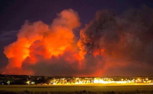
Picture taken last Sunday outside Adelaide of the bushfires. (Source: Matteo Barr // @Matteobarr)
Since mid-week fires have been under control, mainly due to more favourable weather conditions. A trough of low pressure brought both rainfall and cooler temperatures. The bushfire season is typically most severe from December to March in Southern Australia as temperatures soar and rainfall is scarce (January average of 25mm). Weather in the Adelaide region looks to remain fairly tame as the trough of low pressure lingers and brings overcast skies with occasional showers and cooler temperatures.
A small wildfire started about a week ago in the back country trails of the California forests near Yosemite National Park has now turned into a raging wildfire. The wildfire which was initially located outside park boundaries has recently encroached on the national park territory. Covering about 425 square kilometers, the fire is only 2% contained bringing concern to many residents in the area who are under voluntary evacuations. Twelve buildings have been damaged or destroyed by fire already and another 4,500 around Yosemite are at risk. In all, 7,000 firefighters were brought in to battle the wildfire.
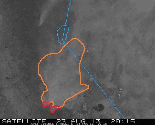
Visible satellite shows extensive amount of smoke in eastern California. Smoke outlined in orange, red the location of the Yosemite fire. (Source: CoD satellite)
Very dry heat has been in place over the region for the last week priming the conditions for wildfires. Relative humidity values are expected to remain in the single digits, combined with temperatures in the mid to high twenties, no relief will be provided to the firemen battling the blaze. Drought has persisted since the beginning of summer for much of California and as of Friday 98% of the state is experiencing drought, with the severity ranging from moderately dry to extreme. Due to the dry conditions, 15-20 large wildfires are currently burning in California.
Usually, the wildfire risk peaks in late September in California as the Santa Ana winds come into play. Santa Ana winds are severe winds that are funneled through the mountains. As these winds are funneled through and descend in height (moving towards the coast) they are heated by natural processes, namely, adiabatic heating, causing for extremely hot and dry weather. These easily spread wildfires by blowing embers towards flammable vegetation.
This week will be another hot one in Southern Manitoba and indeed all over Western Canada. The potential for thunderstorms during the week may temper the heat somewhat.
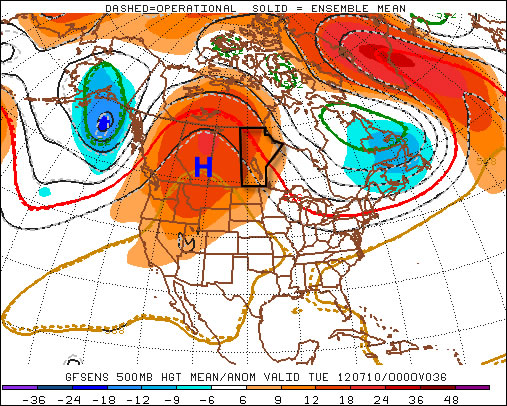
A large ridge of high pressure will reside over Western Canada this week
The weather forecast for this week will be rather tricky. What we do know for sure is that it will be hot all week, with high temperatures being near 30C every day. However, what is somewhat unclear is the risk of thunderstorms during the week. Let’s start with the easy part – the heat.
Temperatures will start out the week in the upper twenties or near thirty on Monday and Tuesday in Southern Manitoba. Humidity levels should remain low on these day making conditions hot, but not excessively so. By Wednesday high temperatures should be be in the low thirties with the humidity making it feel closer to 40. It currently appears that temperatures for late week will remain around the 30C mark, with humidity levels remaining elevated.
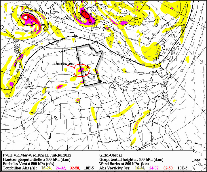
A shortwave will move toward the Eastern Prairies on Wednesday, potentially helping to trigger thunderstorms
The presence of heat and humidity over the Prairies this week will cause the atmosphere to become unstable, creating the risk of thunderstorms on many days. Unfortunately, the thunderstorm forecast is not entirely certain. The issue is that a large region of high pressure, such as the one we’ll be under, does not typically promote widespread thunderstorm activity. In fact high pressure usually suppresses convective activity. It looks like this ridge will not be very good at suppressing thunderstorms, which complicates the forecast significantly.
At this point it looks most likely that Southern Manitoba will see thunderstorms mainly during the second half of this week, from Wednesday onward. During that time period the atmosphere will be most unstable and there will be some weather features moving through the region which may trigger storms. The jet stream has weakened significantly over the Prairies as of late, meaning that most storms will be non-severe in nature. Heavy rain will likely still be a concern though due to slow storm motion. Some severe storms will also be possible just simply due to the instability present in the atmosphere. Although stronger storms will certainly be less widespread than weaker ones. As the week progresses we’ll have to reassess the thunderstorm risk one day at a time.
While my forecast for this week might seem a bit equivocal, that will just be the nature of the weather in the short-term. Unfortunately thunderstorms are just simply unpredictable a frustrating but unavoidable aspect of mother nature.
An extremely powerful storm raced across part of the Midwest and Atlantic region the night of Friday, June 29th and into Saturday, shutting down power to millions of people. The type of storm, called derecho (pronounced day-RAY-cho) is a severe thunderstorm that produces severe wind gusts –downbursts that can produce a large swath of damage in a short amount of time. In addition to the wind threat normally associated with this type of storm, the intense lightning also poses a great danger to residents.
Time lapse video of the derecho trekking across the Midwest and Atlantic states. (Source: NOAA/NASA)
On this occasion, the derecho moved over 10 states and traveled for over 24 hours before reaching the Atlantic Ocean. Over three-and-a-half million people in the Midwest and Atlantic states were without power following the event. Boundless amounts of trees were uprooted, electrical poles taken down, and mobile homes that flipped, could be seen throughout the storm’s path. In all, 27 people lost their lives due to the storm. Hundreds of others were injured. In the storm’s aftermath, searing heat moved back into the region inciting more deaths as heat stroke became a major concern with no electricity to work with. As of Thursday night, July 5th, almost one week since the event passed through these states, there were still a quarter of a million people without power, mostly people north of Washington DC. Many cooling shelters had to be put in place across the area. Heat and humidity advisories were posted, urging residents to limit time spent outdoors to no more than a half-hour at a time. Some cities even cancelled July 4th celebrations due to power outages and excessive heat.
Just one of the many pictures taken of wind damage in the Washington, DC area, product of the derecho. (Source: Associated Press)
The tremendous heat and humidity is expected to stay in place throughout most of the eastern US where 3,000 temperature records were already broken this week, as of Thursday. There is a chance of relief from these extreme conditions next week, as a cold front is forecast to slice its way in a southerly motion through the Midwest and Atlantic states.
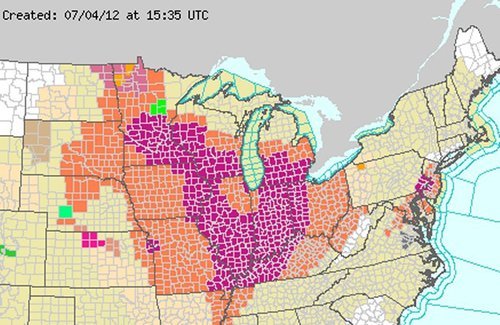
Heat advisories in orange and excessive heat warnings in purple scattered across the Midwest and Atlantic states. On Friday the 6th of July, even a larger area was covered in warning and advisories. (Source: National Weather Service)
Powerful Storm Hits Bemidji
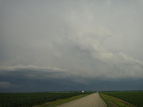
On Monday July 2nd, a few AWM team members headed down to Fargo to chase supercells. The targeted supercells quickly became a cluster of severe storms as they moved into Minnesota. Shortly afterwards, the cluster merged into a bow echo segment, which is very similar to a derecho but smaller in size. Locally, significant damage, similar to what was observed in the Midwest, was reported in Bemidji with the passing of this storm. One boater died as his vessel capsized due to the severe winds and torrential rains. Many trees over 100 years old and power lines snapped easily in the storm’s path, causing widespread power outages locally, in Central Minnesota. Because of all the damage and not much time to tend to downed power lines, the city issued a curfew to residents on Monday night from 11:00 pm to 6:00 am. The Storm Prediction Centre had warned of a bow echo in the days before the event, stressing the severe wind potential. Weather in Central Minnesota this weekend will be similar to Southern Manitoba’s, perhaps a little warmer.
Picture of the back side of the storm as it approaches Bemidji, taken north-east of Fargo in Minnesota. (Source: AWM chase team)