Winter’s Last Gasp

This week will see one last wintry blast in southern Manitoba before spring finally arrives for good.

A surface ridge of high pressure will bring cold weather to southern Manitoba to start the week

Monday

Monday
-7°C / -18°C
Mainly sunny. Chance of flurries.

Today will likely be the coldest day of the week. High temperatures will be in the upper minus single digits, with a chance of flurries. This chance of flurries will arise from low-level instability that will develop as the surface warms during the day. To top it all off, there will be a breezy north-west wind – great!

Tuesday

Tuesday
-5°C / -15°C
Increasing cloudiness. Slight chance of flurries.

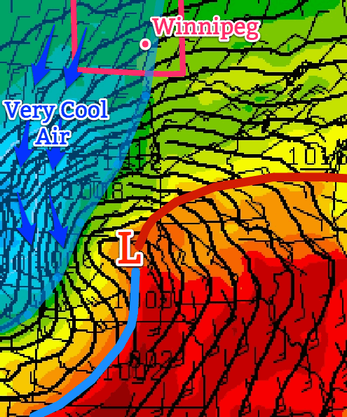
A low pressure system will pass to our south on Tuesday, allowing a cool north-easterly flow to remain established over southern Manitoba. Luckily, that system should remain far enough south to prevent us from seeing any more snow, although a couple of flurries can’t be ruled out.

Wednesday

Wednesday
-4°C / -17°C
Mix of sun and cloud. Chance of flurries.

A brisk northerly flow will remain in southern Manitoba on Wednesday, making for another cold day. High temperatures will be in the mid minus single digits, and there will once again be a chance of flurries.

Record Cold?

With the cold weather that’s expected this week, we will be challenging some cold weather records. The table below shows the record values for the next several days:

Record Cold Minimum and Maximum Temperatures
Date Record Low Record Cold High
Monday April 14 -16.7°C (1893) -7.8°C (1880)
Tuesday April 15 -16.7°C (1893) -6.7°C (1875)
Wednesday April 16 -16.7°C (1875) -4.4°C (1910)
Thursday April 17 -13.3°C (1953) -3.3°C (1953)

It looks like we will come close to setting new records on each of the days listed in the table. Stay tuned to see if we manage to actually break any records!

Long Range

The long range forecast calls for increasing temperatures as we move into the weekend. We’ll likely see seasonal temperatures (i.e. low teens) return by the weekend into next week. There is currently no strong prospective of above-normal weather, but we’ll probably see at least a couple seasonably warm days before the month is out.

Record Low Temperatures Broken

A large swath of record low temperatures were set on the morning of April 15, 2014 across the province of Manitoba thanks to a strong Arctic ridge of high pressure sprawled over the region. Overnight lows were 10-20°C below normal throughout the province. Winnipeg did not set a new record low, however some other locations in the Red River Valley did.

Record Low Temperatures set on April 15, 2014
Site New Record Old Record (Year)
Berens River –23.8°C –19.6 (1997)
Carberry –14.2°C –12.9 C (2000)
Carman –15 C –11.4 C (2000)
Fisher Branch –20.4 C –11.8 C (2000)
Flin Flon –20.5 C –16 (1997)
George Island –19.5 C –16.8 C (1997)
Grand Rapids –24.4 C –13 (1997)
Island Lake –20.7 C –20.6 C (2000)
McCreary –13.7 C –12 (2000)
Oak Point Marine –19.7 C –11.9 (1997)
Pinawa –21 C –12 (2000)
Roblin –11.4 C –11.3 C (1997)
Shoal Lake –11.5 C –10.2 C (2000)
Sprague –16 C –10.8 C (2000)
The Pas –20.5 C –18 C (1986)
Thompson –27.3 C –23.4 C (1985)
Victoria Beach –20 C –11 C (2000)
Wasagaming –15.5 C –15 C (1978)

More record lows will be at the risk of being broken as the week progresses.
Uneventful and Cooler End to the Work Week

A strong low pressure system located to our south-east, in the Northern US Plains, is expected to bring the Dakotas their first snowfall accumulation for the 2013-2014 winter season but will only clip portions of extreme south-east Manitoba.

US Plains low

Low pressure system affecting Northern Plains depicted here for 4PM CDT today. It will keep us cool and cloudy for most of the afternoon/evening.

Friday

Friday

8°C / 1°C
Becoming overcast early on in the day.

Today, temperatures will be slightly on the cool side. The strong system aforementioned will be drawing in cooler air from the north into southern Manitoba. Models are in agreement that rain and snow will stay out of Winnipeg, though there is a slight chance that regions in extreme south-east Manitoba get some showers Friday evening. Winnipeg can expect to see a high near the 8°C mark with increasing cloudiness throughout the day. In the afternoon and evening winds will be stronger 20km/h gusting to 40km/h coming out of the north. It will be a notably chilly day; our high will be some 7-8°C below normal for this time of year. West of the Red River Valley will be even chillier with highs only expected in the mid-single digits. For Friday night, there is a small chance of frost in Winnipeg but areas more at risk lie to the west of the city.

Saturday

Saturday

10°C / -1°C
Mainly sunny.

Saturday looks to be a nicer day, compared to today; mostly sunny skies combined with slightly higher temperatures around 10°C. The only potential downfall looks to be the wind which will still be fairly strong in the afternoon: 20-30km/h from the north before it dies down in the evening. Saturday night will be a chilly one with high pressure in our region, light winds and clear skies for the most part; Winnipeg has a good chance at seeing some frost.

Sunday & Beyond

Sunday

13°C / 4°C
Mainly sunny, a few stray clouds.

The weekend looks to end on a good note with mainly sunny conditions under more of a westerly flow. Highs in the low to mid-teens can be expected for southern Manitoba. Winnipeg looks to see a return to seasonal temperatures with a high of around 13°C weaker winds than the past few days.

For the beginning of the next work week temperatures appear to stay near normal as high pressure moves in. As the high pressure system moves east, a return flow will likely bring in some warmer, above normal, temperatures to the Red River Valley by Tuesday.

A Chance to Dry Out

Wet weather will finally give way this weekend to sunshine and warm temperatures as an upper ridge building into the western Prairies induces a dryer, more stable northwesterly flow aloft over Manitoba.

Friday

25°C / 14°C
A few morning showers giving way to afternoon clearning.
Saturday

27°C / 14°C
Mainly sunny.
Sunday

28°C / 15°C
Sunny.

We’ll see a few morning showers today as the dying remnants of an upper low cycle their way out of the province. Once the scattered showers end in the morning, skies will begin to gradually clear through the afternoon. We’ll see a high of 25 or 26°C with winds out of the north at 20–30km/h. We’ll see clear skies tonight as temperatures drop to around 14°C.

A high pressure system will begin to push eastwards across the Prairies this weekend which will bring some beautiful, dry weather to Southern Manitoba. Temperatures will climb into the high 20’s this weekend under sunny skies with no chance of rain in sight. Overnight lows will dip to around 15°C.

The next chance of precipitation looks to be in the first half of next week as a slow-moving low pressure system meanders across the Prairies. Until then, enjoy a sunny, warm and dry weekend!

Cold Start to the Week

This week will start off feeling a lot more like winter, as temperatures drop well below normal.

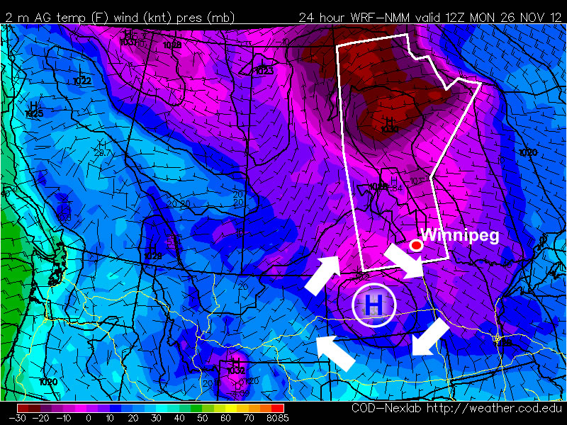
A high pressure system will bring cold conditions to Southern Manitoba on Monday

A high pressure system will bring cold conditions to Southern Manitoba on Monday

Temperatures this morning will be more like those you’d expect in late January, not late November. This morning’s cold temperatures will moderate somewhat by afternoon, with highs in the mid minus teens expected – not exactly November weather! Luckily some cloud cloud should move in during the afternoon hours, allowing Monday night to be significantly warmer than Monday morning. In fact temperatures may rise a bit on Monday night, up into the -6 to -10C range, in association with a weak low pressure system passing through. This low will bring a few flurries to Southern Manitoba overnight, with accumulations of no more than a centimetre or two expected. Unfortunately, another high pressure system will build in behind this passing low, bringing colder temperatures again for the daytime hours of Tuesday. Temperatures will begin falling back into the minus teens on Tuesday morning as cooler air spills in from the north-west. Tuesday night will be another cold one, with lows back down around the -20C mark. It looks like another small warm-up is on the way for Wednesday as yet another passing low pressure centre allows temperatures to climb back up into the minus single digits.

There remains some uncertainly in terms of how the late week period will play out. Models generally agree that we will stay below-normal for Thursday and Friday, but exactly how cold is not entirely clear. There have also been hints of a more active storm track setting up through Southern Manitoba from next weekend into the following week, something to watch as this week progresses.