Sweltering Heat Moves Into Manitoba

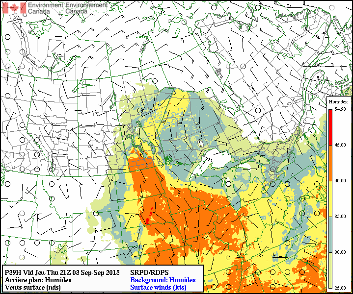
The coming days will be marked by a rare late-summer heat wave that will see hot and humid conditions moving into the Red River Valley, sending humidex values soaring towards the low 40’s. The hot weather will be relatively short-lived, though, as a cold front moving into the region on Friday will send temperatures back towards seasonal values alongside a returning chance for showers or thunderstorms.

Today and tomorrow will both be swelteringly hot days with daytime high temperatures in the low 30’s throughout Winnipeg & the Red River Valley. Humidity will increase dramatically this morning as temperatures begin to warm and the boundary layer deepens and taps into a significantly more humid air mass that’s moved in aloft overnight. By mid-to-late morning, dewpoint values will have climbed into the high teens or low 20’s across the Red River Valley. Combining the high dewpoints with the hot daytime high temperatures, humidex values in the upper 30’s to low 40’s are expected. Environment Canada has issued a heat warning for Winnipeg as well as many other areas across Southern Manitoba including the southwestern corner, Red River Valley, and southeastern Manitoba. Thursday will be slightly warmer and more humid than today is as both the temperature and dewpoint are expected to climb another degree or two higher.

RDPS Forecast Humidex valid the afternoon of Thursday September 3, 2015
The RDPS is forecasting a large swath of humidex values over 40°C (orange) in Manitoba on Thursday afternoon.

With such substantial humidity in place, overnight lows both tonight and tomorrow night will be quite warm, bottoming out near the 20°C mark. Additionally, expect just slightly breezy winds out of the south.

Friday will bring increasing cloud through the day as a cold front approaches from the west. Temperatures should manage to climb into the upper 20’s before the cloud cover cuts off our daytime heating. At this point, it looks quite likely that a large are of showers and thunderstorms will work their way across the Red River Valley through the afternoon. Severe thunderstorm potential looks minimal at this time, but we’ll keep an eye out and issue and outlook if it seems like it might pose more of a threat. Temperatures will cool down into the mid-teens on Friday night with clearing skies.

Unsettled Friday Leads Into Beautiful Weekend

Winnipeg will see a chance for some thunderstorm activity this afternoon with the passage of a weak cold front late today, but today’s unsettled weather will lead into a beautiful August weekend.

Friday
30°C / 17°C
Afternoon cloud; late-day thunderstorm likely

Saturday
27°C / 12°C
Partly cloudy

Sunday
28°C / 18°C
Partly cloudy; risk of showers or thunderstorms late in the day

Thunderstorms Possible in Muggy Airmass

Today will be a hot and muggy day. Temperatures will climb to the 30°C mark by the afternoon with dewpoint values topping out around 20°C, making it feel like the upper 30’s. Winds will be light out of the south.

Things will change as a cold front slumping southwards through the Interlake pushes into the Red River Valley late in the day. Scattered thunderstorms are likely along the front late in the day into the evening; in general the storms will be non-severe, however an isolated severe storm with strong winds or large hail may be possible.

A pleasant night will follow the passage of the cold front; the temperature will drop to around 14°C with clear skies.

Beautiful Weekend Ahead

Saturday and Sunday will be beautiful days for late August with dry weather and warm temperatures in store. Things might take a turn towards the unsettled late in the day on Sunday, although there’s some disagreement on the timing of when the next significant system impacts Winnipeg.

Saturday will be partly cloudy with light northeasterly winds as a ridge of high pressure moves across southern Manitoba. Temperatures will top out around 27°C and drop into the low teens – around 12°C – on Saturday night. Humidity levels will be more comfortable as drier air moves into the province behind Friday’s cold front.

Sunday will be another partly cloudy day with a high near 28°C. More cloud will likely work its way into Winnipeg later in the day ahead of the next low pressure system trundling our way.

There’s fair disagreement on the timing of this next system; the US models bring it through the Red River Valley on Sunday evening, while Canadian models move the system slower and don’t bring it into our region until Monday afternoon. Either way, there’s fairly good agreement that this system will bring a broad area of showers and thunderstorms with it. Depending on the timing and evolution of the system, we may end up with the potential for some severe thunderstorm activity.

Sunday’s weather will be something we’ll keep monitoring and provide an update later in the weekend looking at how this upcoming system is evolving.

More Hot Weather

The hot weather that’s been situated over Southern Manitoba for much of the last few weeks will continue through the remainder of the week as a broad upper-level ridge builds into the region. The weather will become more unsettled towards the end of the week, though, as the upper ridge begins to “flatten out” and multiple disturbances trundle across our region.

500mb flow forecast by the NAM shows a prominent upper-level ridge over the Prairies.

Beautiful Wednesday on Tap

Today will be a gorgeous with mainly sunny skies and warm temperatures as the high climbs to around 26°C this afternoon. Winds will be light thanks to a ridge of high pressure at the surface that will be pushing off into northwestern Ontario by the end of the day.

Wednesday
26°C / 15°C
Mainly sunny

Tonight will see a chance for some showers or thunderstorms as a low pressure system pushes across southern Saskatchewan and into southern Manitoba through the overnight period.

As the night progresses, a warm front will slowly push eastwards towards the Red River Valley, bringing warmer air aloft and the slight chance for some showers or thunderstorms sometime in the second half of the overnight period. The risk really is quite minimal; in general there may be a little too much warm air aloft which would inhibit the development of any shower or thunderstorm activity.

Thirty on Thursday

Thursday will be an absolute scorcher as Winnipeg moves into the warm sector of the low pressure system moving through. Daytime highs will climb into the low 30’s through the Red River Valley with, mercifully, dewpoints around 16°C making for not-too-humid conditions.

Thursday
31°C
Sunny and hot
Thursday Night
19°C
Partly cloudy; risk of a thunderstorm

Thursday night will bring a slight chance for some thunderstorm activity. As things begin cooling off in the evening, moisture advecting into the region may end up destabilizing the lower levels of the atmosphere. If any storms develop, there would be a low risk for any severe weather, although there may be a risk for marginally severe hail should all of the instability be realized.

Unsettled Friday

Summer will continue in full swing on Friday as daytime highs approach the 30°C mark again but will likely remain just shy of it at around 28 or 29°C. The humidity will be more noticeable as dewpoints climb into the high teens or perhaps even break the 20°C mark, making it feel closer to the mid–30’s than the high 20’s.

Friday
29°C / 15°C
Mixed skies and warm; risk of a thunderstorm

Skies will be mixed with the potential for more shower or thunderstorm activity as the low pressure system pushing into the province brings some instability with it. Any shower or thunderstorm activity that develops will likely be somewhat scattered in nature, however isolated strong storms will be possible.

Temperatures will dip down to the mid-teens on Friday night under partly cloudy skies.

Warm Weekend Ahead

The warm weather will continue right through the weekend with highs in the upper 20’s both Saturday and Sunday and comfortable humdity.

Saturday looks quite nice with mainly sunny skies, lower humidity and light winds making for a stellar late-summer day. Nothing to complain about there.

Sunday will be warm, although it will be cloudier than Saturday was. Some showers or thunderstorms look to be possible late in the day through overnight as another low pressure system swings through the province.

Fantastic Weekend In Store

We’ll see a beautiful weekend ahead of us as an upper ridge holds strong bringing sunny skies and warm temperatures to the Red River Valley.

Friday

30°C / 15°C
Chance of morning showers, then mainly sunny & a little humid.
Saturday

27°C / 12°C
Cloudy periods.
Sunday

23°C / 15°C
Increasing cloudiness through the day.

We’ll start today off with some cloud around and a chance of some shower activity in the Winnipeg area along a weak warm front, but that should clear out fairly quickly and we’ll be left with mainly sunny skies as we climb to a high of around 30°C. The humidity will become a little noticeable by the afternoon as a strong capping inversion in place will trap moisture given off by plants near the surface; as a result it will feel a little more sticky than it has as of late, but it shouldn’t be uncomfortable. The warmest air will slump southwards into North Dakota tonight as we drop down to a low of around 15°C with light northerly winds kicking in.

Saturday will bring a few cloudy periods as we climb to a high of around 27°C. Temperatures will drop to the low teens on Saturday night under clear skies.

Things will begin to deteriorate on Sunday with cloud cover pushing in through the day as we hit a high of 23°C or so. Sunday night looks cloudy with a chance of showers or thunderstorms reaching the Red River Valley by early Monday morning. The low will be around 15°C.

Next Week

Forecast precipitation for Sunday night to Monday evening from the GDPS.

Forecast precipitation for Sunday night to Monday evening from the GDPS.

Monday looks to be the most active day next week as a low pressure system lifts out of South Dakota northeastwards into the Lake of the Wood region. This system will be tapping into moist air to it’s south and lifting it northwards and around the backside of the low which, if things go as planned, will result in one of the most widespread rainfalls we’ve seen in a while. Some models are moving towards a more convective solution, though, where a narrow but intense band of thunderstorms will cut a swath through somewhere in the Red River Valley. We’ll have to wait and see, but at this point it certainly looks like Monday will be at least a cloudy, if not rainy, day with temperatures in the low 20’s.

The rest of the week will see some sun and some cloud with temperatures returning to above-normal values in the mid–20’s. A few weak disturbances may create a bout or two of scattered showers or thunderstorms through the week, but at this point nothing significant is in the picture.