Japan Faced with Severe Flooding

The worst flooding that some parts of Japan have seen in decades occurred this past week as a tropical storm brought tropical, moisture-laden air to the country.

[map autofit=”1″ disable_scrollwheel=”1″] [pin]Sendai[/pin] [pin tooltip=”Ikari”]Ikari Nikko, Tochigi Prefecture 321-2806[/pin] [pin]Nikko[/pin] [pin]Kanuma[/pin] [pin]Tokyo[/pin] [pin tooltip=”Joso”]Joso, Japan[/pin] [/map]

Tropical storm Etau had the worst impact on Japan’s biggest island, Honshu. Here heavy rain bands were set up for over 24 hours in the area and rainfall totals were further enhanced by local topography. Unstable terrain leading to mudslides also grew to be a concern as heavy rain fell and the ground became saturated. By the end of this past week, when the rain was all said and done, some villages in central and southern Honshu had rainfall totals near 700mm, with some 24 hour totals topping 500mm. It’s to note that the average monthly rainfall for September in Tokyo is less than a third of that (181mm). Here are a few of the notable rainfall amounts (provided by weather.com) :

  • Ikari 551*mm* in 24 hours.
  • Nikko 668*mm* rainfall total.
  • Kanuma 444*mm* in 24 hours, which is more than double the previous 24 hour record for the city (record 212*mm* in 2002).
  • Sendai central business district 269*mm* 24 hour total
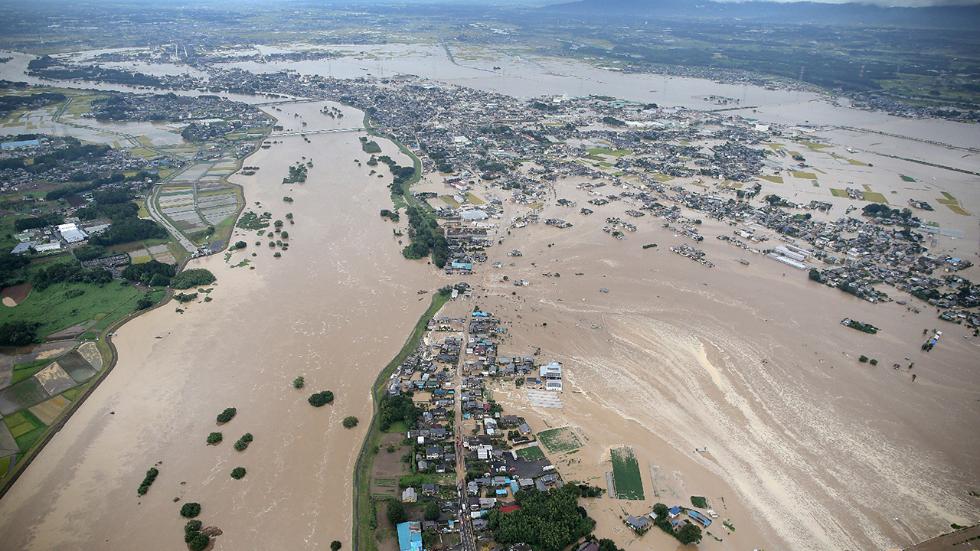
Levees of the Kinugawa River breached in Joso from the heavy rains. (Source: AFP/via TWC)

What resulted from these very high rainfall amounts was historic flooding, mainly north and northeast of Tokyo. Over 13,500 buildings were reported to be completely flooded out by officials in result of the heavy rain falling as well as some levees being breached north of Tokyo. In total 3 people have been confirmed to have died from this rainfall event and 23 are still missing; mostly from landslides. It was reported that 185,000 were forced to leave their homes, while over two million more were advised that they should leave by authorities. It’s not possible to assign a dollar amount to the damages yet but authorities speculate it will at least be in the hundreds of millions.
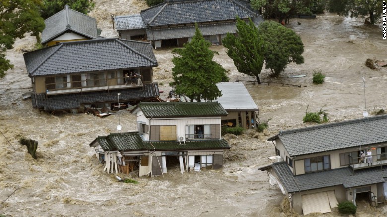
Flooding in the city of Joso, where floodwaters nearly reached the second story of homes. (Source: CNN)

A few showers are expected this weekend in the Tokyo area but nothing close to the magnitude of what seen this past week.
Typhoon Nangka Wreaks Havoc on One of Japan’s Main Islands

This past week a typhoon made landfall on one of Japan’s islands, the island of Shikoku and with it brought winds the equivalent of a category one hurricane gusting up to 185km/h.

[map type=”terrain” autofit=”1″ disable_scrollwheel=”1″] [pin]Island of Shikoku[/pin] [pin]Kamikitayama, Japan[/pin] [/map]


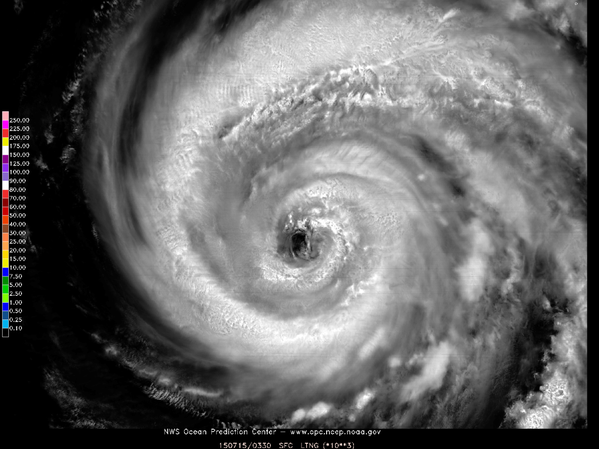
Nangka initially formed in the middle of the Western Pacific Ocean about over a week ago and slowly strengthened as it approached Japan; it traveled over 5000km to make landfall. Over open waters it peaked at the equivalent of a category four hurricane, with sustained winds of over 200km/h and gained super typhoon status. Slightly cooler ocean waters (of 26°C to 27°C) towards Japan weakened the typhoon somewhat before it made landfall, but with that said, the typhoon’s impacts were still fairly significant. In expectation of the typhoon 550,000 residents were either issued a mandatory evacuation notice or voluntary evacuation notice, in the most prone-to, low-lying areas near the coast.

Beautiful satellite image of Nangka earlier this week while it was still over open waters. (Source: NWS OPC)

In total, two people perished from the typhoon and about three dozen people sustained injuries – thankfully it wasn’t worse due to good planning by authorities to get the people most at risk out. Numerous rail runs and flights were cancelled, affecting about 200,000 people’s daily activities. Some flooding did occur as the typhoon brought a plume of tropical moisture to the region with it, which led to rainfalls in excess of 700mm in the hardest hit areas in 48 hours (740mm reported in Kamikitayama). Just over 100 houses were reported to have been completely flooded out

Since Nangka has made landfall it has progressed to its dissipating stage, and possibly extratropical transition by the end of the weekend. However, it will still bring with it the threat of heavy rainfall in the northern Japanese islands and mountainous areas even though it continues to weaken. On average there are 16 typhoons in the Western Pacific in a year, and this year’s count is currently at seven. Most storms form in the Western Pacific between May and November (because shear is weaker) but there are occasional storms that form in the other months of the year.

Elsewhere in Weather News: December 20th, 2014

Snow Squalls Paralyze Several Japanese Prefectures

This week’s Elsewhere in Weather News focuses on western side of the Japanese islands of Hokkaido and Honshu which have seen significant amounts of snow from a snowstorm that hit midweek.

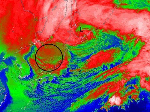
An area of low pressure which was moving northeast along Japan’s west coast quickly deepened to a 949mb low and whipped Japanese islands with winds of 60 to 100km/h. These winds, combined with widespread amounts of 20-30mm of rain ahead of the system. By the time the low reached the northern islands of Japan, strong northwesterlies kicked in over Japan’s main island of Honshu. Cold Siberian air infiltrated in over the Sea of Japan behind the low which stalled out, creating prime conditions that would sustain the development of snow squalls for a long period of time.

IR Satellite image of the mature low pressure system over northern Japan with circled area showing snow squalls forming over the Sea of Japan.

Snow squalls occur when cold air moves over a warm body of water, creating an unstable temperature profile. With the instability in place, snow squalls were able to from over the Sea of Japan and make their way to the western side of Honshu. Orography – the effect that terrain has in creating localized impacts on the weather – also played a role in providing additional lift which resulted in higher accumulations. The storm prompted blizzard warnings to be issued across 11 prefectures in western Honshu and Hokkaido.

These are the areas that saw the highest snowfall amounts recorded – accumulations generally ranged from 50cm to 120cm, but locally higher amounts were recorded near Niigata, Japan, up to 200cm. The storm caused 19 fatalities and forced cancellations of 600 flights across Japan.

Mountainous terrain located to the southeast of Niigata enhanced the snowfall amounts in the region.
Last week, another storm of similar strength brought significant snow to parts of Honshu as well as the northern island of Hokkaido. The forecast looks to favour more snow squalls as a similar setup to what was seen this past week – a strong low will be located near the northern island of Hokkaido and will draw in more cold Siberian air over the Sea of Japan.

Elsewhere in Weather News: October 11th, 2014

Two Dangerous Storms Spin Up

Notable activity has expanded from the tropical waters of the Western Pacific into the Bay of Bengal over the past week. We mentioned in last week’s EIWN that typhoon Vongfong could be a threat to Japan sometime this week – this has since become a reality. Formerly known as super typhoon Vongfong, typhoon Vongfong took aim at the Japanese island of Okinawa early this morning. Packing sustained winds of 140km/h which gusted to over 200km/h, the storm caused power outages to 27,000 residents and some locations on the island reported over 200mm of rain.

News agencies in the region report 20 injuries as of Saturday morning but thankfully no deaths from the storm. Vongfong is expected to curve northeast and slowly transition to an extratropical storm, but not before it brings significant rainfall to Japan’s main islands. This could be bad news, especially for the mountainous regions, as this is the second storm to hit Japan in the span of a week. With already saturated ground, these regions are more prone to landslides.

Cyclone Hudhud Develops

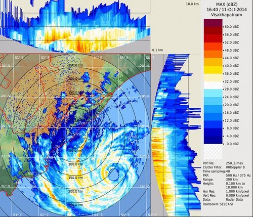
The second tropical storm is cyclone Hudhud which spun up only a few days ago. With sea surface temperatures approaching the 30°C mark in the Bay of Bengal, Hudhud quickly became a “very severe cyclonic storm” as classified by India’s Meteorological Department. As of Saturday morning Hudhud was 200 kilometres offshore of India with sustained winds of 205km/h.

Visakhapatnam radar image of cyclone Hudhud Saturday morning. Outer bands are already affecting India's coast and the eye is visible offshore. (Source: India Met Department)
Visakhapatnam radar image of cyclone Hudhud Saturday morning. Outer bands are already affecting India’s coast and the eye is visible offshore. (Source: India Met Department)

The evacuation of 150,000 people was underway along the coast because a significant storm surge of up to 1.8 metres is expected along the coast. Hudhud is forecast to make landfall overnight tonight just southwest of Visakhapatnam and continue inland, where it will die off, but not before dumping significant amounts of rain. The hardest hit areas can expect over 250mm of rain.