Winnipeg & the Red River Valley will see one more day of unsettled weather before warmer, drier weather moves in for the weekend.
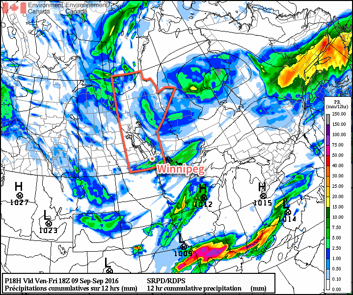
Wet weather is on the way this morning as a low pressure system passes through the Red River Valley, bringing showers with the risk of a thunderstorm across the region. All the rain should move out by midday with just a very slight chance of isolated showers through the afternoon as the cloud breaks up a bit. Temperatures will climb to a high near 18°C with a gusty northwesterly wind increasing to 20-30 km/h in the afternoon. Clouds will scatter tonight as we head to a low near 9°C. There will, however, be some lake effect showers streaming off the lee of the lakes, so depending on the exact wind direction, areas to the south-southeast to east-southeast of both Lake Winnipeg and Lake Manitoba may see some additional cloud and shower activity into Saturday morning.
A swath of showers is expected across Southern Manitoba this morning.
Saturday will be a pleasant day with light winds and partly cloudy skies.1 Temperatures will rebound to around 20°C for a high. Clouds will begin moving in on Saturday evening for a mostly cloudy night with low temperatures dipping to around 12°C.
Sunday will bring mixed skies to Winnipeg & the Red River Valley with gusty southerly winds developing ahead of an incoming low pressure system. Temperatures will be warm, with highs climbing to around 24 or 25°C. Sunday night will continue fairly cloudy with a chance of showers. Temperatures will dip to around 11°C.
Long Range
The start of next week looks quite cool as a cold front pushes through on Monday bringing distinctly fall-like weather as cool Arctic air pushes into the region. Daytime highs in the mid-teens look quite possible for the first couple days next week before temperatures rebound back towards seasonal mid-week.
Winnipeg’s seasonal daytime high is currently 20°C while the seasonal overnight low is 7°C.
Save for any remaining lake-effect cloud/showers first thing in the morning. ↩
The weather is taking an abrupt turn today as significantly cooler air moves into Southern Manitoba behind the low pressure system that brought numerous thunderstorms to Winnipeg & area on Wednesday night.
Today will see unseasonably cool temperatures as a high pressure system moving into Manitoba draws air from the Arctic and ushers it southwards into the province. The cool air, coupled with the August sun, will result in plenty of cloud and some scattered showers through the afternoon. With a northwesterly wind of 20-30 km/h, temperatures will climb to a high near 20°C.
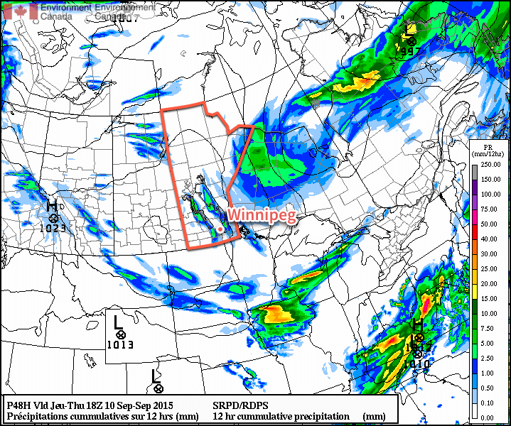
Skies will remain fairly cloudy tonight as cool air continues to push southwards. For areas in the western Red River Valley, it appears that the Arctic air will trigger some lake-effect showers that will move southwards off of Lake Manitoba. There’s a lesser chance that similar showers will develop off of the south basin of Lake Winnipeg as well. Winnipeg will end up tucked between the two and should remain dry for much of the night. Expect overnight lows to dip down to around 8 or 9°C.
The bright green swath over the western RRV shows the expected lake-effect showers on Friday night.
Saturday will be a drier day with the cool weather continuing. Daytime highs will climb to around the 19°C mark under mixed skies. Skies will clear out for Saturday night for another cool one with overnight lows near 8°C.
Sunday will return to closer to seasonal temperatures with highs near 24°C under mainly sunny skies. There will be a bit of cloud moving through later in the day as warmer air begins moving into the region, but no precipitation is expected in the Red River Valley with it at this point.
So, while it will be cooler, we’ll get a short break from the severe weather threat that has been so frequent the past few weeks across Southern Manitoba. Next week looks like a bit of a mixed bag with dry, warm weather through the first half of the week being replaced by cooler, more unsettled weather in the second half.
Winnipeg’s seasonal daytime high is currently 24°C while the seasonal overnight low is 11°C.
The weather through the second half of the week will have a distinctly fall-like feel to it as a building ridge of high pressure over the Prairies brings cooler weather to Southern Manitoba with daytime highs in the upper teens and overnight lows in the single digits.
Thanks to a high pressure system building in from the Arctic, temperatures will be fairly cool over the coming few days with daytime highs around 18°C and overnight lows in the mid-to-upper single digits. Winds will be out of the northwest at around 20km/h today and tomorrow, however swing around to the south for Friday.
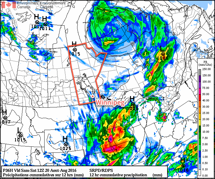
The only real notable weather will be tonight. With very cool air pushing into Southern Manitoba[1], lake-effect cloudy and precipitation will likely develop overnight into Thursday morning. Showers or drizzle are possible in the lee of the lakes beginning late in the evening tonight until mid-morning on Thursday. Even if the precipitation doesn’t occur, some cloudiness is a certainty, so expect cloudy or mixed skies on Thursday morning with a clearing trend into the afternoon.
The RDPS forecast model is picking up on the potential for lake-effect precipitation overnight into Thursday morning, shown here by the trails of precipitation accumulation in the lee of hte lakes over Manitoba.
Otherwise, the weather will be quite benign for the remainder of the work week.
Long Range Outlook
Looking ahead to the weekend, it looks like warmer weather will begin to return to the region. Daytime highs will climb back into the mid–20’s with breezy southerly winds on Saturday. Sunday will feature a high in the mid–20’s again with strong southerly winds ahead of a developing low pressure system. There looks to be a slight chance for some rain on Sunday evening/overnight into Monday, however the odds look slim at this point.
All in all the weather will be fairly nice for the coming 5 days, so enjoy it; just remember to begin packing a jacket or sweater for the evenings!
850mb temperatures tonight are forecast to fall to around 3°C. ↩
A wild rollercoaster of weather conditions begins today as a fairly potent weather system develops today, rocketing temperatures close to the 30°C mark before things take a turn for the worse as a stormy transition sends daytime highs struggling into the low teens by the end of the weekend.
Friday: Another Beautiful Summer Day, Stormy End?
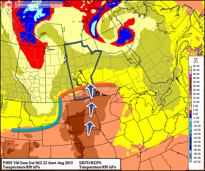
Today will be a gorgeous day as warm air surging northwards ahead of a developing low pressure system in the Northern Plains of the United States. Temperatures will climb into the upper 20’s this afternoon under fairly sunny skies. Some cloud cover will start working into the region in the afternoon alongside a slight chance of showers as a weak mid-level disturbance rolls through. In the evening, a low-level jet (LLJ) begins to intensify as the low pressure system deepens and brings more lift into the region, spreading more cloud into the region.
The RDPS is showing a warm front at 850mb just north of Winnipeg near midnight tonight. The LLJ is represented by the blue arrows and will be the trigger for thunderstorm activity tonight.
A round of thunderstorms is possible tonight along the nose of the LLJ. The risk is somewhat conditional, dependent exactly how how much moisture is advected northwards within the LLJ. Assuming enough moisture is present to realize the instability, we head to MIST:
Moisture: This will be the most uncertain aspect of tonight’s thunderstorm potential. Dewpoints at 850mb are forecast to be around 10°C, which should be enough to realize the elevated instability, however it’s a farily narrow ribbon, and if amounts are lacking a bit, convective initiation will struggle.
Instability: Fairly strong instability aloft will be present. Models suggest mid-level (700 – 500mb) lapse rates of 7–8°C/km this evening, which would be considered quite strong. If the expected moisture builds into the region, MUCAPE values of around 1000 J/kg should be realized.
Shear: The overall shear looks great, with widespread bulk shear values of 40–50kt expected over the Red River Valley this evening. The high bulk shear values are produced through a combination of strong velocity shear through the vertical coupled with large, looping hodographs indicative of favourable directional shear.
Trigger: Isentropic ascent of the LLJ as it overruns a warm front draped west-to-east along the international border coupled with falling heights ahead of the incoming upper-level low should provide a strong enough trigger to initiate convective activity.
All this combined means that there’s a fairly good chance of some thunderstorm activity through the Red River Valley this evening. It likely won’t be severe; I think the higher threat for severe storms activity will be more in southwestern Manitoba where things will initiate earlier and rooted closer to the warm front. That said, it certainly can’t be ruled out that there may be a rouge severe thunderstorm cell through the evening into the first half of the overnight period. Expect a low temperature near 17°C.
Mixed Bag On Saturday
There remains some uncertainty as to how Saturday will play out, but it seems quite probable that we’ll see some shower or thunderstorm activity through the day. There may be a few sunny breaks, but it should be cloudier than not through much of the day. If any rain manages to hold off until later in day, marginally severe thunderstorms could be possible in the Red River Valley, however it would be dependent on how much heating occurs (read: how sunny it manages to be). Even with decent heating shear looks marginal which will provide a barrier to significant thunderstorm development.
This comes with a caveat, however, as the forecast will be dependant on the timing of the cold frontal passage. With current best indications, there will be a slight risk of severe thunderstorms to the east of the Red River Valley on Saturday afternoon, however if the front slows down a little, that threat could shift westwards into the Red River Valley. We’ll take a closer look at it in an update tonight or tomorrow morning.
That said, temperatures will top out around 25°C with fairly light winds.
Saturday night will see the Red River Valley on the back side of the low and behind the cold front; colder air will begin pushing in alongside strengthening northerly winds. Expect a low near 13°C.
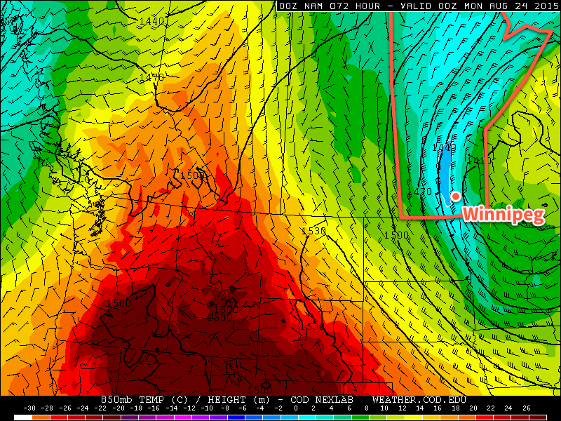
Miserable Sunday
Sunday will be a miserable day by any standard. Very cold air over the region—850mb temperatures are forecast to be a chilly 0–2°C—will keep our daytime highs to just the low teens. Very strong northerly winds will be in place over the region; sustained winds will likely reach 50–60km/h with gusts reaching as high as 80km/h or so. On top of all that, wrap-around precipitation will work it’s way across the Red River Valley, bringing more rain and/or showers to the region.
The NAM is forecasting 850mb temperatures of 0-2°C and very strong northerly winds over the Red River Vallye on Sunday. Miserable.
To top it off, with lake temperatures near 21°C and 850mb temperatures forecast to be near 0°C, lake-effect or lake-enhanced rain/drizzle is probable in the lee of the lakes, persisting possibly into Monday morning.
The low temperature on Sunday night will be around 6 or 7°C.
Hopeful in the Long Range
The good news is that the long-range forecast looks good. Rather quickly behind the passage of this low, a broad upper-level ridge is forecast to begin building back into the Prairies. This will bring significantly warmer weather back to the region. Considering it’s still August and we’re talking about daytime highs in the low teens, a quick bounce back into the mid- to upper–20’s for daytime highs will be much appreciated.