Wet End to a Wet Long Weekend

This long weekend will end on a rainy note – big surprise! Conditions should gradually improve as we move into the work week.

image

A significant weather system will spin just to our south for the next couple days

Monday and Tuesday

Monday
image
Periods of Rain
11°C / 7°C
Tuesday
image
Periods of Rain Ending
14°C / 5°C

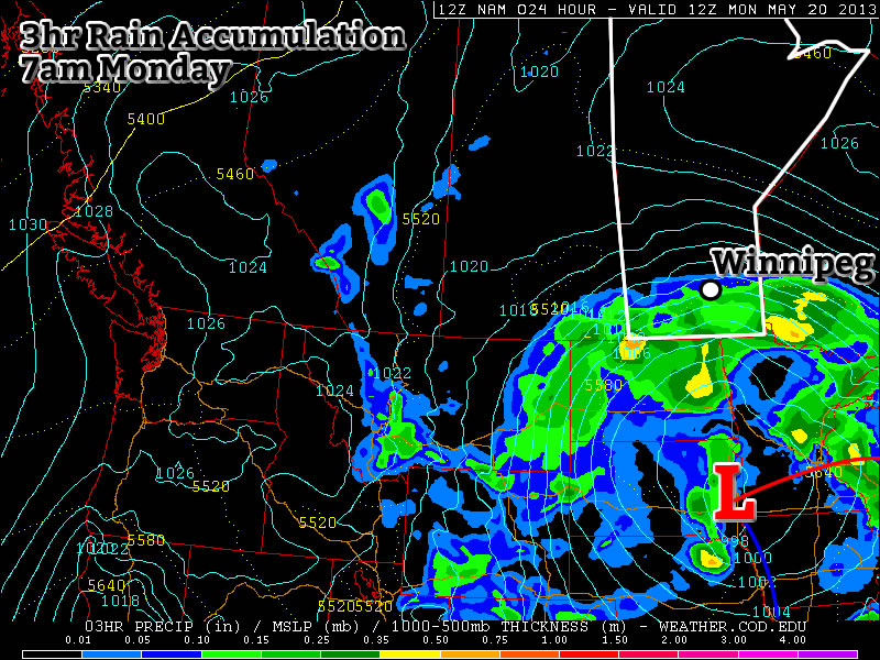
A powerful weather system over the Dakotas/Minnesota region will continue to bring rain to Southern Manitoba on Monday. Weather models wrap a band of rain through much of Southern Manitoba through all of Monday and even into Tuesday. Models are struggling to resolve the intensity of this rain and therefore total accumulations are a major question mark. If this band does indeed stall through Southern Manitoba for the next day and a half as models indicate, then storm total accumulations could well be in the 50 to 100mm range that models are predicting. On the other hand if things pan out differently than the models predict, which looks probable, then we’re probably looking at more like 30 to 60mm on a widespread basis (these numbers include Sunday accumulations as well by the way). I believe there is a sufficient moisture feed for those high end amounts (close to 100mm) on a localized basis. However, the intensity of rain appears to be lower than model predictions, so I think in general storm totals will be closer to the 30-60mm range mentioned above. Either way a lot of rain will be had today and tomorrow, not the way most people had hoped to spend their Victoria Day.

Wednesday

Wednesday
image
Mainly Sunny.
20°C / 5°C

Conditions should improve for Wednesday as we experience a brisk north-easterly flow behind Monday’s system. Temperatures should be in the upper teens or lower twenties.

Long Range

The late week outlook looks fairly seasonal temperature wise, with little or no additional precipitation. Long range guidance doesn’t give a clear picture of how the rest of May will play out. It doesn’t appear that we’re headed for any kind of significant cool down, but a large warm up doesn’t look likely…hopefully the long range forecast will show more clarity later this week.

The Heat Is On!

This week will feature warm to hot weather in Southern Manitoba, a trend which is expected to continue into the long weekend.

Temperatures will be hot over much of Central North America this week

Tuesday’s high temperatures. Reds indicate temperatures near 30C.

A ridge of high pressure will be in place over Manitoba on Monday and Tuesday of this week. This ridge will pump warm air into the province, allowing high temperatures to reach the high twenties and even low thirties. Monday will be quite nice, with temperatures in the high twenties over all of Southern Manitoba. Humidity levels on Monday will remain low, making the day rather comfortable. By Tuesday the humidity will increase somewhat, but will still remain reasonable even as temperatures climb to around thirty degrees (except in Western Manitoba where the air will be a bit more tropical). A cold front will slice through the province on Wednesday, knocking down humidity levels with a strong westerly wind. However, temperatures won’t drop off by much, with highs staying in the mid to upper twenties on Wednesday.

CAPE graphic. CAPE is a measure of how unstable the atmosphere is, in other words, how severe a storm could potentially become

CAPE values are expected to be moderate to extreme over the prairies early this week. CAPE is a measure of how unstable the atmosphere is, in other words, how severe a storm could potentially become

You may be wondering if this heat will generate thunderstorm activity as the cold front moves in on Wednesday. The short answer to that question is maybe, but I will elucidate. There will certainly be severe storms in Saskatchewan on Monday and Tuesday this week, but the threat in Manitoba is less clear. At this time it looks like our best chance for seeing storms will be on Tuesday night into Wednesday morning as storms that develop over Saskatchewan and North Dakota drift into Manitoba during the overnight period. Even though these storms will happen after dark they may still be severe as they will have warm and humid air to work with. There may also be the risk of thunderstorms during the day on Monday and Tuesday in portions of west-central Manitoba (i.e. Swan River, The Pas, etc). Since these regions aren’t our focus, I won’t go into much further detail than that. Nocturnal thunderstorms may drift into Western Manitoba on Monday night or Tuesday morning, but aren’t expected to impact the majority of Southern Manitoba.

After the cold front passes through on Wednesday there will be a couple of days where the heat “reloads” ahead of the long-weekend. In other words Thursday and Friday will be a bit cooler, although still warm, with temperatures more in the mid twenties. It is expected that hot weather will crank up again for the long-weekend, with present modelling suggesting that temperatures near thirty degrees will be possible on Saturday, Sunday, and Monday. It is too early to be certain in those predictions, but at this point the long-weekend is looking rather nice…if you like hot weather that is.