Elsewhere in Weather News: December 23rd, 2012

From Snow to Tornadoes in the US this Week

This past week a large trough of low pressure swung through the eastern half of the United States bringing a wide range of weather; from blizzards in the Midwest, to tornadoes in the South-East and even dust storms in Texas.

The tornado, confirmed by the National Weather Station, occurred in the early morning hours on Thursday and cut a path of destruction through Mobile, Alabama. Preliminary reports indicate that the tornado was of EF-1 strength (between 138km/h and 178km/h winds) and had a path spanning 11 kilometers. It tore down roofs, uprooted oak trees and cut power off to about 10,000 residents. Most of the power was restored by Friday but the cleanup will certainly still be underway this weekend.

Blizzards, spanning from Nebraska to Michigan, accompanied this potent trough of low pressure and thundersnow was even experienced at times. Over 600 flights out of Chicago were cancelled and officials had to close various interstates across the Midwest, simply because it was too dangerous to travel. Here are a few of the higher snowfall amounts recorded as of Friday:

  • Gaylord, MI: 50cm
  • Madison, WI: 34cm
  • Des Moines, IA: 32cm

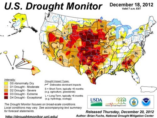
On Wednesday, near Amarillo, Texas, as the front came through it was accompanied with very strong winds (gusting to 80km/h) which managed to stir up a large dust storm. This dust storm was caused in part by the severe winds but also the severe drought currently occurring in the Southern Plains, including Amarillo, where the dirt is loose and can easily be picked up. The dust storm went through Interstate 27 producing near zero visibility and triggered a 23 vehicle pile-up.
By Saturday the trough will have moved off to Atlantic Canada, much of the US Midwest and Plains will experience below-normal temperatures as arctic air floods in from the Canadian Prairies.

Drought

Significant drought throughout the US Plains, both long-term and short-term. (Source: Drought Monitor, NDMC)

We again wish you happy holidays and all the best in the New Year!

Elsewhere in Weather News: July 7th, 2012

Devastating Derecho Races Across US States

An extremely powerful storm raced across part of the Midwest and Atlantic region the night of Friday, June 29th and into Saturday, shutting down power to millions of people. The type of storm, called derecho (pronounced day-RAY-cho) is a severe thunderstorm that produces severe wind gusts –downbursts that can produce a large swath of damage in a short amount of time. In addition to the wind threat normally associated with this type of storm, the intense lightning also poses a great danger to residents.

Time lapse video of the derecho trekking across the Midwest and Atlantic states. (Source: NOAA/NASA)

On this occasion, the derecho moved over 10 states and traveled for over 24 hours before reaching the Atlantic Ocean. Over three-and-a-half million people in the Midwest and Atlantic states were without power following the event. Boundless amounts of trees were uprooted, electrical poles taken down, and mobile homes that flipped, could be seen throughout the storm’s path. In all, 27 people lost their lives due to the storm. Hundreds of others were injured. In the storm’s aftermath, searing heat moved back into the region inciting more deaths as heat stroke became a major concern with no electricity to work with. As of Thursday night, July 5th, almost one week since the event passed through these states, there were still a quarter of a million people without power, mostly people north of Washington DC. Many cooling shelters had to be put in place across the area. Heat and humidity advisories were posted, urging residents to limit time spent outdoors to no more than a half-hour at a time. Some cities even cancelled July 4th celebrations due to power outages and excessive heat.

Wind damage

Just one of the many pictures taken of wind damage in the Washington, DC area, product of the derecho. (Source: Associated Press)

The tremendous heat and humidity is expected to stay in place throughout most of the eastern US where 3,000 temperature records were already broken this week, as of Thursday. There is a chance of relief from these extreme conditions next week, as a cold front is forecast to slice its way in a southerly motion through the Midwest and Atlantic states.

Heat warnings

Heat advisories in orange and excessive heat warnings in purple scattered across the Midwest and Atlantic states. On Friday the 6th of July, even a larger area was covered in warning and advisories. (Source: National Weather Service)

Powerful Storm Hits Bemidji

On Monday July 2nd, a few AWM team members headed down to Fargo to chase supercells. The targeted supercells quickly became a cluster of severe storms as they moved into Minnesota. Shortly afterwards, the cluster merged into a bow echo segment, which is very similar to a derecho but smaller in size. Locally, significant damage, similar to what was observed in the Midwest, was reported in Bemidji with the passing of this storm. One boater died as his vessel capsized due to the severe winds and torrential rains. Many trees over 100 years old and power lines snapped easily in the storm’s path, causing widespread power outages locally, in Central Minnesota. Because of all the damage and not much time to tend to downed power lines, the city issued a curfew to residents on Monday night from 11:00 pm to 6:00 am. The Storm Prediction Centre had warned of a bow echo in the days before the event, stressing the severe wind potential. Weather in Central Minnesota this weekend will be similar to Southern Manitoba’s, perhaps a little warmer.

Bemidji storm

Picture of the back side of the storm as it approaches Bemidji, taken north-east of Fargo in Minnesota. (Source: AWM chase team)