Elsewhere in Weather News: March 28th, 2015

First Significant Severe Weather Event of the Season Strikes Oklahoma

This past Wednesday severe storms erupted across much of Oklahoma bringing with them very large hail and even tornadoes. It was the biggest severe weather day this year in the states, up to now (but many more are to come). A surface low was located in central Oklahoma with dryline extending southward, cold front crashing south from the north side of the low, and a warm front extending northeastwards from the low. There were two main focus areas for the storms – along the dryline and near the triple point/along the warm front. A moderate risk was issued by the SPC and covered the areas of concern. The outlook also included a 5% tornado risk with 45% hatched hail probabilities. A moderate jet streak was in place with dewpoints in the high teens, which together provided sufficient shear and CAPE for supercells.

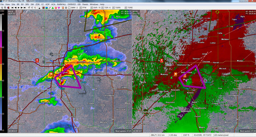
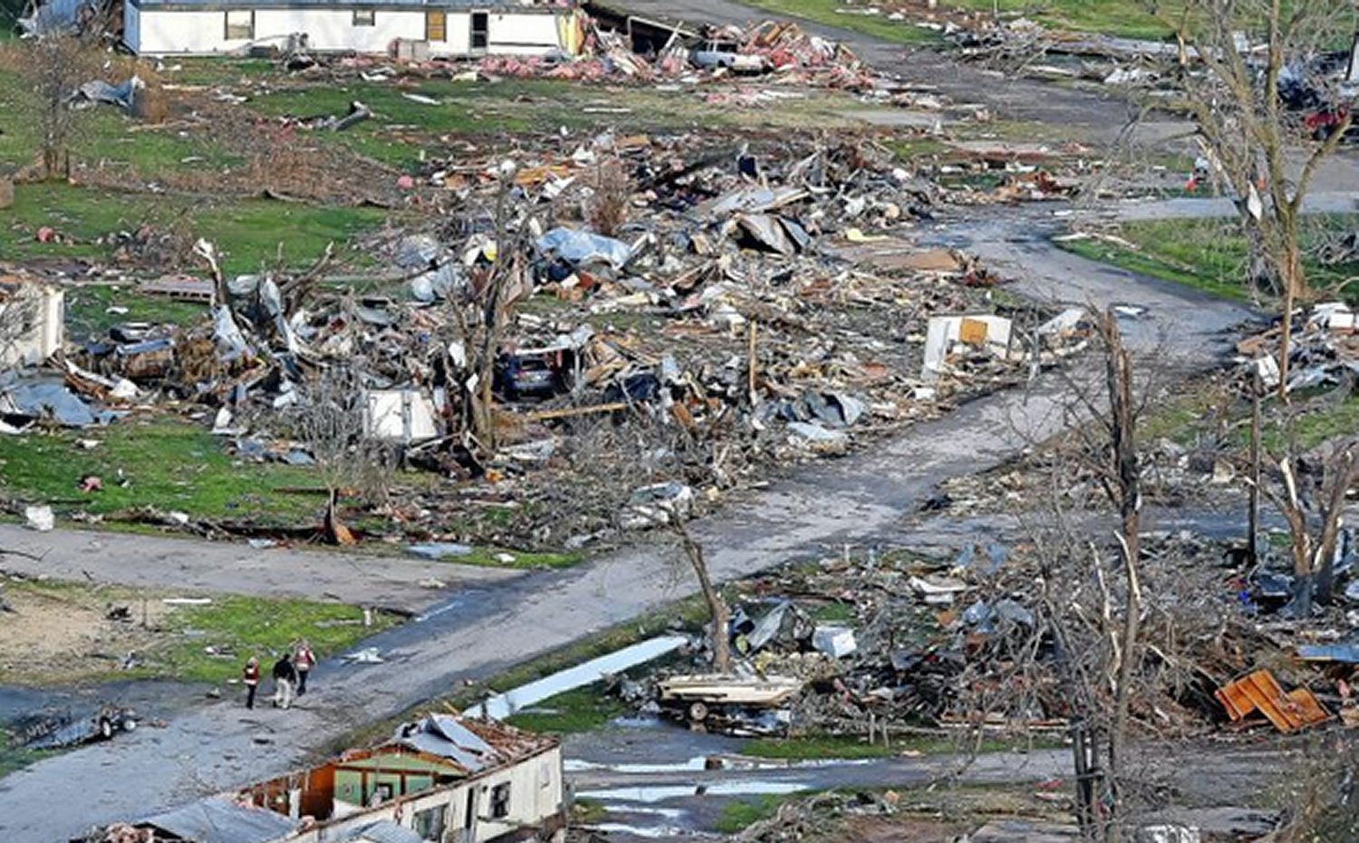
[map type=”terrain” autofit=”1″ disable_scrollwheel=”1″] [pin]Sand Springs[/pin] [pin]Moore[/pin] [/map]

As expected, several storms initiated on Wednesday afternoon and grew into supercells. Two supercells were of most concern before storms consolidated into squall lines: one near Tulsa and one near Oklahoma City. The storm that approached Tulsa showed strong rotation on radar early in its lifetime –a tornado warning was able to be issued well before it hit the city. By the time it reached a suburb of Tulsa, Sand Springs, a tornado touched down and tore through a trailer park. In addition to that, hail, the size of tennis balls, were reported in Tulsa’s metro region as the supercell’s hail core passed over the city. The tornado (preliminary rating of EF-2) injured over a dozen people and one person lost their life in the trailer park.

Aerial view of the damage to the trailer park in Sand Springs. (Source: Tulsa World)

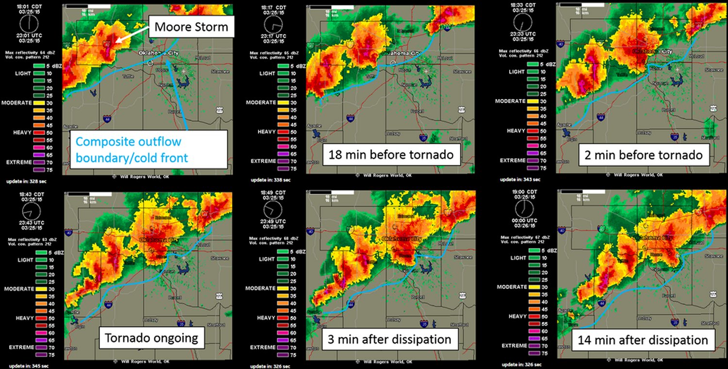
The Oklahoma City storm fired off the dryline initially but then got undercut by the cold front – meaning it had little tornado potential. Interestingly enough, the supercell was able to catch up to the cold front and interact with it, enhancing the vorticity in the area – likely being a contributing factor to the formation of the tornado. With this mesoscale interaction playing a significant part in the cause of the tornado, not much lead time was provided to residents (it happened quickly). Unfortunately the twister (preliminary rating of EF-1) touched down in the city of Moore, OK which got hit by a devastating twister in 2013 and had seen two other strong tornadoes since 1999. No injuries were associated with this one, thankfully.

Compilation of radar images before/during/after the Moore tornado showing the storm's interaction with the cold front. (Image compilation by @VORTEXJeff / Twitter)
Compilation of radar images before/during/after the Moore tornado showing the storm’s interaction with the cold front. (Image compilation by @VORTEXJeff / Twitter)

The pattern could become active again by the middle of next week, but it is still too early to be certain. April to late May is typically the busiest time of the year for severe weather in the Southern US Plains, due to plentiful moisture before the jet stream shifts further north for the summer.

Elsewhere in Weather News: December 28th, 2013

EIWN’s Top 3 Events of 2013

This past year several historical events have taken place – from right here in Canada, to Tornado Alley, to half-way across the globe in the Philippines. The post this week will feature a countdown of this year’s top 3 severe weather events.

3. Alberta Floods – June 19th to June 22nd

This event was fuelled by moisture from the Gulf of Mexico that was able to stream all the way north to southern Alberta, where an upper low was positioned. The situation would not have been as bad if a blocking pattern wasn’t in place further north, stalling the upper level low over southern Alberta. As all this moisture was pushed up the Rockies, condensed, and further, fell as precipitation leading to significant flooding along the foothills. Extreme rainfall amounts were recorded in Canmore at 220mm (half their annual rainfall) and High River which recorded 325mm, both in less than two days.


Rainfall totals for Alberta up to the 21st of June, note the high amounts along the foothills. (Source: AB Environment)
Rainfall totals for Alberta up to the 21st of June. (Source: AB Environment)

This severe weather event was the costliest in Canadian history, reaching two billion dollars in damages. An estimated 100,000 residents were forced to evacuate, a total of 32 communities were in a state of emergency and 2,000 armed forces were brought in to help out. Unfortunately, four people lost their lives in this event.
A few more facts from the event:

  • The Saddledome (home of the Calgary Flames hockey team) flooded up to the 10th row of seats
  • Over 1,000km of roads were destroyed
  • Calgary received 88% of their average monthly precipitation within 48 hours

2. Moore Tornado – May 20th

On the afternoon of May 20th, one of the worst scenarios possible occurred; tornadic supercells spawned a strong tornado on the ground and tore through a city of 50,000 people. Conditions were ideal for supercells to develop as the CAPE was in the 5000J/kg, shear was in the 50kt range and a dryline trigger was present. The city of Moore, Oklahoma took a direct hit from an EF-5 tornado. The massive tornado, which had a maximum width of 2.1km, raced across Oklahoma for 27km before it eventually lifted after passing through Moore.


Radar scan (reflectivity and velocity) at the time the tornado hit Moore. Large debris ball present on the radar over the city as well as a tornado vortex signature. (Source: Personal files/GR3 radar)

Damage in Moore was severe as whole neighbourhoods were swept off the map. An estimated 1,150 homes were destroyed with a total of two billion dollars in damages. The tornado also took the lives of 24 people and injured 377, but the toll could have been significantly higher had the NWS not put out a strongly worded warning for the Oklahoma City/Moore area a good 15 minutes before the tornado arrived.

Interestingly enough, 11 days later the widest tornado on record touched down in El Reno, Oklahoma measuring 4.2km in width, just 60km west of Moore. This tornado was rated an EF-3 and sadly took the lives of 8 people, including the respected researcher and storm chaser Tim Samaras.

A few significant facts from the Moore tornado:

  • The Storm Prediction Center had issued a moderate risk with a 10% hatched tornado risk for the area that day
  • A 10-ton water tank was thrown one kilometer away
  • The tornado was on the ground for almost one hour

1. Super Typhoon Haiyan – November 3rd to November 11th

Our top weather story is one that is still fresh in our minds. Typhoon Haiyan (also known as Typhoon Yolanda) made landfall in the Philippines as a strong category five typhoon, bearing winds of approximately 315km/h and a central pressure below 900mb. With these values, Haiyan would be the strongest tropical cyclone to ever make landfall.


IR image of super typhoon Haiyan 5 hours before it made landfall in the Philippines. (Source: Co. State University)

In total, 7,000 people perished from this storm, with still a thousand missing, making it the deadliest typhoon on record in the Philippines. Extreme damage totaling an estimated 1.5 billion dollars occurred mainly due to wind and storm surge. Tacloban was the hardest hit city as the storm surge of 6m took out buildings over one kilometer inland. 90% of the city was reported to be destroyed.

A few significant facts from super typhoon Haiyan:

  • 11 million people were affected by Haiyan
  • Haiyan made a second landfall in Vietnam as a category one typhoon
  • 4 typhoons made landfall in the Philippines in 2013 (Utor, Nari, Krosa, Haiyan)