This past week featured severe thunderstorms that tore through the Nebraska countryside producing extremely large hail in the region. Conditions were primed for a severe weather outbreak this past Tuesday; moisture streamed up from the Gulf of Mexico, a strong jet streak was in place overhead and the environment was relatively uncapped. Convective Available Potential Energy (CAPE) was quite high that day which was a significant contributor to the large hail sizes observed. Generally the higher the CAPE, the faster the updraft velocity which means that the updraft can support larger hailstones. Supercell thunderstorms were triggered Tuesday afternoon and persisted through the evening, trailing along the warm front that bisected the region.
In total over 200 hail reports were submitted on Tuesday and of these 38 were considered large hail reports (hail of 5cm in diameter or larger). The most damage caused that day appeared to come out of the town of Blair, Nebraska where hail caused major damage. Windows were blown out and car windshields smashed by the baseball size hail that fell – damage totaled in the hundreds of millions. Other storms along the warm front, the weather feature that triggered the severe weather, moved into the Omaha area not only bringing hail, but also torrential downpours. 13.5mm of rain was recorded in 3 minutes at the Omaha airport!
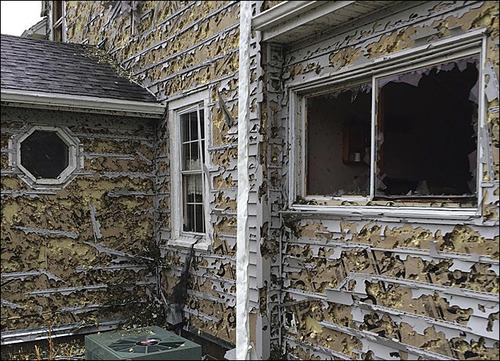
Hail damage in Hoover, NE shows the strength of baseball size hail, completely shredding the siding and breaking the windows. (Source: Kevin Krohn)
There is a possibility for more severe storms this weekend in Texas and New Mexico, but the parameters are not as as favourable for severe weather as seen this past Tuesday in Nebraska. Models show the active pattern continuing in the US Plains into next week, and rightfully so as severe weather season nears its peak.
All kinds of extreme weather have been plaguing the United States this week; from tropical storms, tornadoes to blizzards to severe Santa Ana winds, they’ve just about seen it all. It was all happening yesterday due to a dynamic low pressure system centered in the Northern US Plains. High pressure building behind the low pressure system was responsible for the Santa Ana winds. The tropical storm, a completely separate system, has been targeting the gulf shores for a few days now.
The powerful fall low pressure system was drawing in brisk air from the north behind it which helped produce ideal conditions for blizzard conditions in the Black Hills. It was not unusual to see snowfall rates in excess of 5cm/h throughout the day on Friday in the region. The hardest hit area in regards to snow looked to be Lead, SD, which by Friday night had received 110cm (in less than 48 hours!), and another 20-30cm could fall before deformation zone moves off.
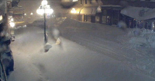
Streetcam picture of the snow accumulated in Lead, SD. Keep in mind there was no snow on the ground less than 48 hours ago! (Source: Twitter: @TylerJRoney)
Incredible image of a large snow drift almost completely covering the front door in Deadwood, SD. (Source: Twitter: @ReadingReineke)
In the warm sector of the same system severe thunderstorms were spawned on Friday. A few supercells formed in the late afternoon near the triple point in northern Nebraska/extreme southern South Dakota. With extremely favourable conditions for tornadoes, storms quickly started rotating. The number of tornadoes is still unclear at this time but a violent, long tracked, wedge tornado which was reported to be over a mile wide, touched down. Per initial reports it appears as though Wayne, NE was the hardest hit on Friday by this tornado. Houses and factories were completely demolished and two dozen people were reported injured. A squall line also evolved further south into Kansas and Oklahoma where large hail and severe wind were the main threats.
Damage of a factory destroyed in Wayne, NE from the tornado that hit the town. (Source: Twitter: @action3news)
The Santa Ana winds have been a treat to California this week, too. These winds get funneled through the Mountains of Southern California, subsequently warm and dry as they descend in elevation. Gusts in excess of 110km/h have been tearing through Southern California bringing with them an extreme fire risk. This prompted the National Weather Service (NWS) to issue multiple red flag warnings for the area – these warnings are issued when conditions are ideal for wildfires and quick intensification. The NWS also added that these were the worst winds in five years.
As for the tropical storm (Karen) spinning in the Gulf of Mexico, it does not appear that it will become a significant hurricane. Strong wind shear has been affecting its development for the past few days. It will likely make landfall as a tropical storm with winds of tropical storm force, but possibly even weaker depending on how much the shear tears the storm apart. The location of the landfall looks to be on the south-east gulf shores of Louisiana. It doesn’t appear as though its effects will be too significant to the US – heavy rain will be the main threat with Karen. Otherwise, the tropics continue to remain unusually calm and no other developments elsewhere in the Atlantic basin are expected in the near future.
Cooler weather has settled over Southern Manitoba and while it won’t stay below normal for long, we won’t really be hitting above normal temperatures any time soon, either. The week ahead looks like a middle-of-the-road week with some sun, some cloud, an a chance for some showers.
850mb Analysis of the θe field from the NAM, valid at 00Z Tuesday Evening
Today will bring clear skies to Winnipeg with diminishing winds. Our expected daytime high of 2°C will be a whopping 9°C below our normal daytime high of 11°C for this time of year. Tonight we’ll drop down to a chilly -7°C under clear skies.
Tomorrow will start off sunny and then cloud over in the afternoon as a low pressure system moves across Southern Manitoba. The main shortwave will track through the interlake, bringing in slightly warmer temperatures aloft across Southern Manitoba. The main surface low, however, will track just south of our border, keeping the warmer near-normal, temperatures to our south. Given that Southern Manitoba will have the southern low skirting just south of the International Border and be under the influence of large-scale ascent associated with the shortwave tracking further north, it looks quite likely that an area of showers will blossom as the system moves into Manitoba, and that regions along or just north of the Trans-Canada highway southwards to the U.S. Border will see showers on tomorrow afternoon. As ususal, the exact track will be key, however it’s fairly likely that most communities in the Red River Valley will see some showers tomorrow.
Shortwave vs. Surface Low? A shortwave is the term applied to a troughing disturbance in the upper atmosphere that travels along with the main flow aloft. A surface low is a low pressure system present in the lowest levels of the atmosphere. Each shortwave will often have a surface low pressure system associated with it and the two work in tandem to link the upper and lower atmospheres together. They are not co-located, however, and when compared on a map, can be hundreds of kilometers away from each other.
Things will clear out quickly tomorrow evening and then the rest of the week looks fairly benign, with daytime highs around 7°C and overnight lows around -5°C. Temperatures may jump back to normal on Friday with the approach a more significant low pressure system, but models disagree on it’s exact placement and some keep us on the cooler side of thigns; we’ll have more on that later in the week.
8-14 Day Temperature Anomoly Outlook from the NAEFS model from 12Z April 15, 2012.
Temperatures across the Eastern Prairies have been slightly below normal lately due to a persistant upper low anchored near Southampton Island in Hudson Bay. This low has maintained a trough and NW flow aloft over the Eastern Prairies and has been responsible for helping shunt systems further south and keeping us cooler. This large-scale pattern is expected to hold for the next 6-9 days, however signs are pointing to a breakdown of the low and a significant upper ridge to build across the Prairies in the Day 9-12 range. Ensemble models seem to agree with this idea, and as shown above, the NAEFS currently has fairly high confidence for a return to above-normal temperatures next week.
Elsewhere In Weather News
Tornado Alley Hit by Major Outbreak
The major tornado outbreak that occurred in the US Plains on Saturday, April 14th 2012 will be remembered for many years to come. Every single ingredient for long-tracked, damaging tornadoes was present. The storms developed due to a low pressure system centered over the Nebraska/Kansas border which drew in moist air from the gulf and into the Plains –- this spawned extremely strong supercells along its dryline as it slowly moved eastwards.
In anticipating major storms, the SPC had given plenty of warning to the affected areas, issuing a high risk in the 2-day outlook which is a very rare occurrence that has only happened once before. The high risk for tornadoes meant that within a 40km radius there was a 45% chance of an EF-2 to EF-5 tornado in parts of Nebraska and Kansas.
Probabalistic Tornado Graphic issued by the Storm Prediction Center on Saturday, April 14th.
Supercells had already exploded in the morning in the state of Kansas but did not produce any tornadoes until about 11:30am when a tornado had been spotted just north-east of North Platte, KS. From then on, tornado sightings were reported every 15 minutes until nightfall as just about every supercell from Nebraska to Oklahoma had a good chance of producing a tornado. Also to be kept in mind is that these supercells produce huge hail, reaching softball size (11.4cm in diameter), and cause significant damage to just about everything as they fall.
Violent tornado near Cherokee, OK
In all, around 100 tornadoes were sighted and luckily, many of them kept populated areas out of harm’s way as they missed villages and major cities. Unfortunately, there was one major city that had not been spared. The city of Woodward, OK (town of 12,000) was directly hit by a tornado, with a preliminary rating of EF-3. Five deaths and 29 injuries occurred in this city as the sirens did not go off, due to the tornado having cut their power. What aided the probability of injury and loss of life was also that the tornado had hit just after midnight, when most residents were asleep and it is extremely difficult to spot a tornado.
Some of the strongest tornadoes produced on Saturday – preliminary ratings:
EF-4 that just missed Salina, KS.
EF-3 that struck south-east Wichita, KS.
EF-3 that killed 5 in Woodward, OK.
EF-2 that damaged more than 75% of Creston, IA (town of 250).
Here are a couple of the many breath-taking photos/videos captured yesterday by storm chasers and those affected:
EF-4 tornado that just missed Salina, KS.
A large tree limb punched through the car’s side, product of the Wichita tornado. (Source: Cory Mottice)
Home moved off its foundation and destroyed in Wichita, KS.
Very powerful tornado north of Soloman, KS. (Source: AP)
Unfortunately the severe weather threat didn’t end there. More tornadoes were reported in the Upper Mississippi Valley on Sunday associated with the same system. As the system will race east on Monday, tornado probabilities are greatly reduced across the eastern half of the country however, severe thunderstorms are certainly not out of the question as cold air clashes with the warm air situated ahead of the system.