Elsewhere in Weather News: April 26th, 2014

Tornadoes Tear through North Carolina

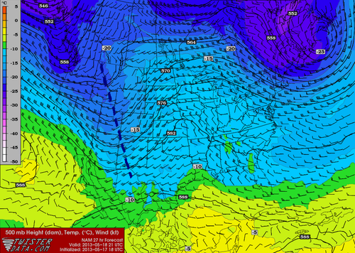
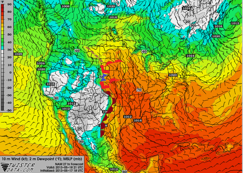
It was an active day severe weather-wise for parts of East Coast yesterday, where tornadoes, large hail and strong winds were all experienced. These severe storms were triggered by a shortwave racing across the mid-section of the US and approaching the East Coast. Moisture was plentiful streaming up from the tropics which promoted low cloud bases and sufficient amounts of Convective Available Potential Energy (CAPE). In addition to this, wind shear was significant enough to support supercells as well as an approaching cold front from the west acting as a trigger mechanism. Considering all of these, conditions were primed for supercells in North Carolina and Virginia.

Trucked flipped in Chicod, NC. (Source: WITN)

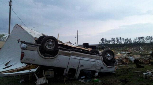
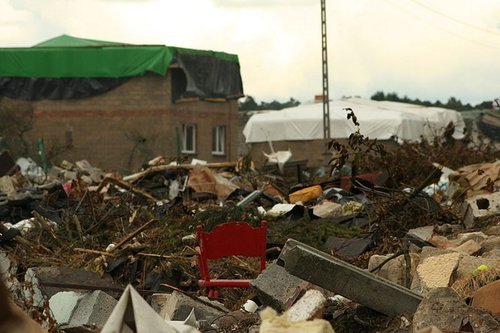
Supercells quickly formed Friday afternoon across eastern parts of North Carolina and Virginia as the atmosphere destabilized. Elizabeth City appeared to be the hardest hit, likely by straight line winds and not a tornado. As of Friday evening, several injuries were reported because of the strong winds downing trees and power lines in the city. According to the SPC there were 10 different tornado reports which appeared to account for three different tornadoes. Fortunately, no injuries or deaths were reported to be associated with any of the tornadoes.

This event comes at the same time a significant negatively-tilted trough arrives ashore on the west coast. The trough is expected to bring severe weather from the US plains this weekend, to the East coast for the beginning of next week. Sunday through Tuesday look to be the most dangerous days where numerous tornadoes could touch down across Dixie Alley and the Midwest. As of Friday evening, the SPC had already issued a Moderate Risk, mentioning strong tornadoes in their discussion and suggesting a high risk (highest tier) upgrade could be in order in future updates.

With only 89 tornadoes reported in the US as of April 13th, that number could easily double within the next few days.

Elsewhere in Weather News: May 18th, 2013

Severe Weather Event South of the Border: Possible AWM Chase Sat/Sun

Trough

Negatively-tilted trough on Saturday late afternoon. (NAM) (Map source: Twisterdata)

The same system that will cause Southern Manitoba to have a rainy May long weekend is expected to produce a string of severe weather days across the Central US, starting today, continuing through at least Tuesday. A negatively-tilted longwave trough approaching from the west will help to provide the necessary wind shear, lift, and instability for severe storms to develop. A broad surface low with an extending cold front from Central South Dakota through Nebraska will be in place with a warm front slicing through north-east South Dakota. Another, stronger, low pressure center will be in place in Kansas with an extending dryline all the way down to Texas. These features will offer enough lift for severe storms on Saturday. This, combined with other severe weather ingredients such as a stiff low level jet (LLJ), high amounts of instability, deep low level moisture and low cloud bases is ideal for severe weather and tornadoes. The Storm Prediction Center has issued a Moderate Risk for Nebraska and Kansas with a Slight Risk extending up to North Dakota for their 2 Day Outlook as of Friday night.

Surface Analysis

Surface analysis of the Plains. (Map source: Twisterdata)

As of Friday evening these ingredients appeared to be maximized in the vicinity of north-western Kansas near the Nebraska border. Storms will not be confined to this area though, as strong to severe storms will still be possible into South Dakota and down into Oklahoma, but whether they will be tornadic or not is still to be seen.

The ingredients that will be in place tomorrow in South Dakota:

  • Instability: about 2000J/Kg of MLCAPE (mixed layer)
  • Surface dewpoint: 18°C
  • Shear: 40 knots (0-6km shear)
  • LLJ: 20 knots
  • Lifting condensation levels (cloud bases): around 750m

With the LLJ being only 20 knots, an AWM Chase is still up in the air. If models tend towards a stronger LLJ, the chase will likely be on with a target somewhere in Central South Dakota.

Sunday also offers a significant severe weather threat as the trough continues its trek towards the east. Severe weather risk would extend into Southern Minnesota all the way down to Oklahoma. There is still some uncertainty about Sunday but it does look like another significant severe weather outbreak day for the Plains and Upper Mississippi Valley. Stay tuned in the comments section as the event approaches, updates will be posted.

AWM Chase is On!

Two of the AWM team members will be out chasing this setup along with a student from the University of Manitoba. You can keep up with their chase right here:

new TWTR.Widget({
version: 2,
type: ‘list’,
rpp: 30,
interval: 30000,
title: ‘May 18, 2013’,
subject: ‘AWM North Daktoa Chase’,
width: ‘auto’,
height: 500,
theme: {
shell: {
background: ‘#3c3c3c’,
color: ‘#eeeeee’
},
tweets: {
background: ‘#eeeeee’,
color: ‘#2c2c2c’,
links: ‘#489ce1’
}
},
features: {
scrollbar: true,
loop: false,
live: true,
behavior: ‘all’
}
}).render().setList(‘WeatherInThePeg’, ‘awm-team’).start();

Elsewhere in Weather News: July 21st, 2012

On Saturday July 14th, an unusually strong tornado struck the northern half of Poland leaving a large path of destruction in its wake, in the region of Pomerania. The twister, at times measuring one kilometer in width, tore up trees, disintegrated houses within seconds, and downed power lines for several kilometers. The village of Wycinki and surrounding forest, Bory Tucholskie National Park, were hit the hardest: upwards of 500 hectares of forest were completely flattened by the tornado; over 100 homes were destroyed; and trains had to reroute because of fallen debris on the tracks.

Dramatic video of the tornado scraping by a house and the aftermath. (Source: Youtube/profoundtransformati)

The tornado was estimated to be of EF-2 strength with winds churning at around 200km/h. One fatality in the village of Wycinki was reported when a man tried to take cover in his cottage and was struck by the walls collapsing on him. There were also an additional 10 injuries reported due to the tornado.

Poland tornado

The tornado from a different angle in Sztum. (Source: Associated Press)

Severe weather in Poland appears to be occurring more frequently these past years. This year alone, Poland has seen its fair share of severe weather spanning from large hail events to flash flooding. Tornadoes are not a common occurrence in Poland but they have happened before. The following lists a few significant outbreaks recorded in the past:

  • The Lublin, Poland tornado of 1931 which killed six people and is thought to have been an EF-5 tornado (however that ranking has not been proven).
  • The May 1958 2-day tornado outbreak in Poland which caused three deaths and over 100 injuries.

  • The August 2008 outbreak where multiple tornadoes including 5 EF-3 and 1 EF-4 were spawned killing three people in south-central Poland.

2008 Poland tornado

Picture of the devastation caused by the August 2008 tornado outbreak in Poland. (Source: Wikimedia)