Windy Spring Weather Ahead

Windy conditions will usher in a return to seasonal temperatures for Winnipeg’s second half of the week.

A pair of cold fronts moving through ahead of a weak Arctic high will shape Winnipeg’s weather over the next few days. For today, temperatures will climb to a high near 19°C but northwesterly winds will pick up to around 30 gusting 50 km/h. The city will also see partly cloudy skies with a chance of showers. The first chance is early this morning as the cold front moves through. A second chance of showers or thundershowers will develop later in the afternoon as a bit of leftover instability burns off. The wind will ease this evening with temperatures falling too a low near +4°C.

On Thursday, Winnipeg will find itself south of another approaching cold front. Northwesterly winds will strengthen to 40 gusting 60 km/h, keeping highs in the region to around 13°C. Winnipeg will see partly cloudy skies through much of the day. As the cold front moves into the region Thursday evening, the city should see cloud cover thicken up with a chance of showers. The wind will ease through the evening as skies gradually clear. Temperatures head to a low near +1°C.

Moderate west-northwesterly winds will develop over soutehastern Saskatchewan and southern Manitoba on Thursday.

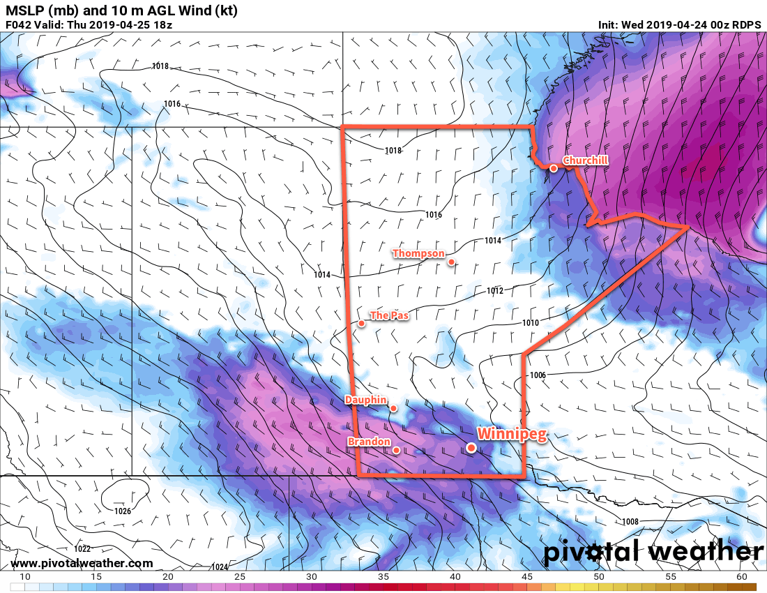
On Friday, the Arctic ridge will finally push into the region. Skies will stay mixed for much of the day and Winnipeg will once again see a high near 13°C. Winds will be a lot calmer than Thursday at around 20 km/h. Skies will finish clouding over on Friday night with a low again near +1°C. Winds will remain light overnight.

Long Range Outlook

Winnipeg will see plenty of cloud cover this weekend with a chance for rain developing late Sunday into Monday. Some forecasts show an organized low developing as much as 25 mm of rain to parts of southern Manitoba on Sunday night through Monday night. We’ll be keeping an eye on that system as it develops later this week.

Today’s seasonal daytime high in Winnipeg is 14°C while the seasonal overnight low is +1°C.

Spring Temperatures Heating Up

Winnipeg will see a shift towards milder temperatures this week with daytime highs climbing into the upper teens.

A ridge of high pressure moving across the Red River Valley will bring sunny skies with northerly winds near 20 km/h. Temperatures will also be seasonably mild with highs around 17°C this afternoon. Under clear skies and light winds, temperatures will dip back down to a low near +3°C tonight.

For Tuesday, Winnipeg will see afternoon cloud as a low pressure system tracks eastwards across the Prairies. Winds will strengthen from the south to around 30 gusting 50 km/h in the afternoon as a warm front moves through the region. Winnipeg should see a high near 19°C. Heading into the evening, the entire region will see a chance of showers. That chance will persist through much of the night as a little bit of cooling aloft moves in. Winnipeg’s low temperature will be a mild 9°C with a gradually diminishing wind.

Temperatures will climb into the upper teens or low 20s thorugh the Red River Valley on Tuesday.

By Wednesday morning, Tuesday’s disturbance should be leaving the region. In its wake will be partly cloudy skies and northwesterly winds of 20 to 30 km/h. With a high near 19°C once again, there may be enough instability left across the region to see a few showers pop up through the day. The wind will ease Wednesday evening and Winnipeg will head to a low near +4°C under partly cloudy skies.

Long Range Outlook

The rest of the week will bring near-seasonal temperatures to Winnipeg with increasing cloudiness into the end of the week. The next organized chance for precipitation looks to be on the weekend as a complex of low pressure systems moves across the Prairies and northern Plains.

Today’s seasonal daytime high in Winnipeg is 13°C while the seasonal overnight low is 0°C.

Warm With A Chance of Showers

Winnipeg will continue to see mild spring weather with a chance of showers on Saturday morning.

A low pressure system crossing the central Prairies today will result in southerly winds up to 40 gusting 60 km/h developing in the Red River Valley. These breezy conditions will draw warmer air northwards, resulting in one of the warmer spring days so far this season. The temperature in Winnipeg will climb to around 20°C this afternoon with a partly cloudy skies. The wind will gradually ease tonight with more cloud spreading into the region ahead of an approaching cold front. Winnipeg will see a low temperature near 8°C.

Southerly winds will bring warm spring temperatures to the Red River Valley today.

The region will see a chance of showers beginning late Friday night through Saturday morning as the cold front moves through. Once it passes, Winnipeg will see sunnier skies for the afternoon with northwesterly winds near 30 gusting 50 km/h. Temperatures will return to seasonal values behind the cold front with a high near 12°C in Winnipeg. The wind will taper off Saturday evening, leaving the city with a few clouds as temperatures head to a low near +3°C.

Sunday will bring partly cloudy skies to the city again with light winds and a high near 15°C. There’s a slight chance of afternoon showers along a weak surface trough stalled over western Manitoba into the Red River Valley. The region will see a few clouds overnight as temperatures drop to a low near +1°C.

Long Range Outlook

Next week will start off with plenty of sunshine and seasonal to slightly above-seasonal temperatures. Some rain is possible mid-week as a surge of warmer air pushes eastwards. After that moves through, Winnipeg will likely see highs in the upper teens with variable cloudiness.

Today’s seasonal daytime high in Winnipeg is 12°C while the seasonal overnight low is -1°C.

More Showers Lead to Cooler Conditions

Winnipeg will see another chance of showers this morning followed by the passage of a cold front which will bring seasonably cool conditions back to the region.

The city will start today with some showers moving through the region followed by cloudy skies with a chance of drizzle. Temperatures should reach a high near 5°C with northwesterly winds near 20 km/h through much of the day. A cold front will push through in the evening, bringing a chance for flurries as it passes. Behind it, the cloud cover will begin to break up as temperatures head to a low near -9°C.

A few showers will spread across southern Manitoba this morning.

The rest of the week will see Winnipeg entrenched under a weak Arctic ridge extending from Hudson Bay southwards through the province. The city will see variable cloudiness as systems pass by to the south and slightly below-seasonal temperatures. Winds will continue from the north to northeast around 20 to 30 km/h both Tuesday and Wednesday.

Long Range Outlook

The rest of the week looks quiet with variable cloudiness and near-seasonal temperatures.

Today’s seasonal daytime high in Winnipeg is 8°C while the seasonal overnight low is -4°C.