Hurricane Patricia from the ISS. © Scott Kelly (Twitter: @StationCDRKelly)

Patricia Breaks Western Hemisphere Records, Makes Landfall in Mexico

On the 20th of October a tropical depression formed in the Eastern Pacific, well south of Mexico and began drifting slowly northwest into an area of warm sea surface temperatures (SST’s) of about 30°C with low shear.

[map type=”terrain” autofit=”1″ disable_scrollwheel=”1″] [pin]Cuixmala[/pin] [pin tooltip=”La Manzanilla”]Selva de Melaque[/pin] [pin]Puerto Vallarta[/pin] [/map]

Typically hurricanes of this strength are not seen this late in the Eastern Pacific, but very warm SST’s were still present in the area – perhaps influenced by the strong El Niño that is ongoing, provided the fuel necessary for a hurricane of this strength. After drifting northwest without significant intensification early in the week, Thursday is when Patricia began intensifying as it produced a large burst of convection. Patricia intensified to a rate the Western Hemisphere had not seen before – it dropped an incredible 100mb within 24 hours, and at the same time Patricia reached category five status which is the highest category on the Saffir-Simpson scale.

Enhanced IR image of Patricia early Friday morning. (Source: CIMSS)

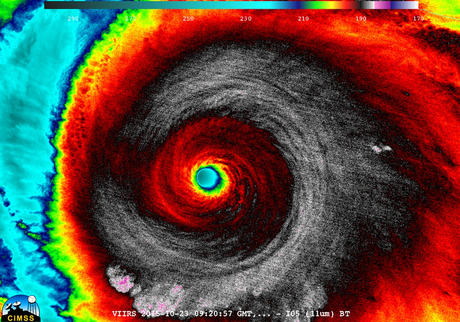
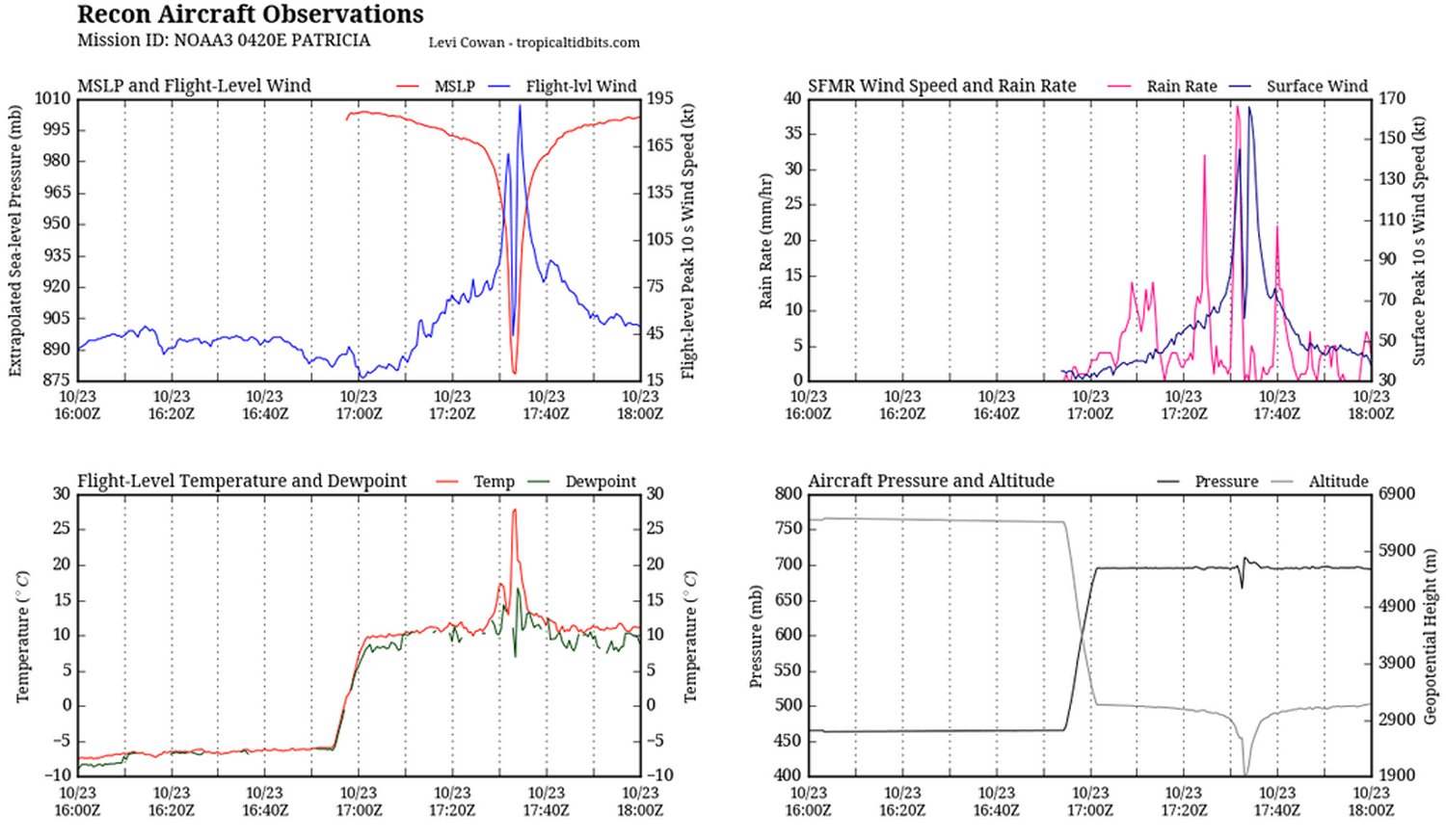
As it neared its peak early Friday morning, the hurricane hunters flew through the hurricane to sample the environment. The data collected was astonishing; a drop sonde had measured a surface pressure of 883mb with a 45kt surface wind. From this they extrapolated that the central pressure of Patricia was about 879mb at the time of the drop sonde, breaking another Western Hemisphere record for lowest pressure observed. Winds also peaked in Patricia around the same time, where sustained winds were 325km/h, with possible gusts up to 400km/h. Thankfully Patricia’s wind field did not extend very far from its core because it was a fairly compact inner core with pinhole eye – hurricane force winds only extended about 40km from the centre of the storm.

Aircraft data collected Friday morning from the Hurricane Hunters. To note is the top left graph which measured a very low extrapolated MSLP as well as the extremely high winds at aircraft level. In the bottom left graph it's also to note the steep rise in temperature (of about 15C in the eye - the result of subsiding air warming. (Source: @tropicaltidbits)
Aircraft data collected Friday morning from the Hurricane Hunters. To note is the top left graph which measured a very low extrapolated MSLP as well as the extremely high winds at aircraft level. In the bottom left graph it’s also to note the steep rise in temperature (of about 15C in the eye – the result of subsiding air warming. (Source: @tropicaltidbits)

What’s it like flying into one of the strongest ever observed? Here’s a video of the Hurricane Hunters flying in Patricia:

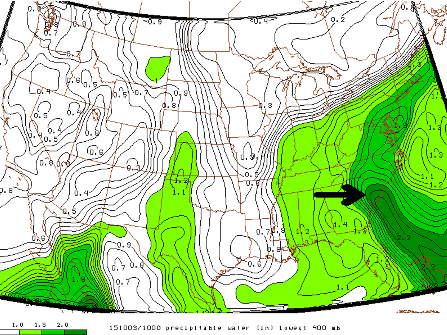
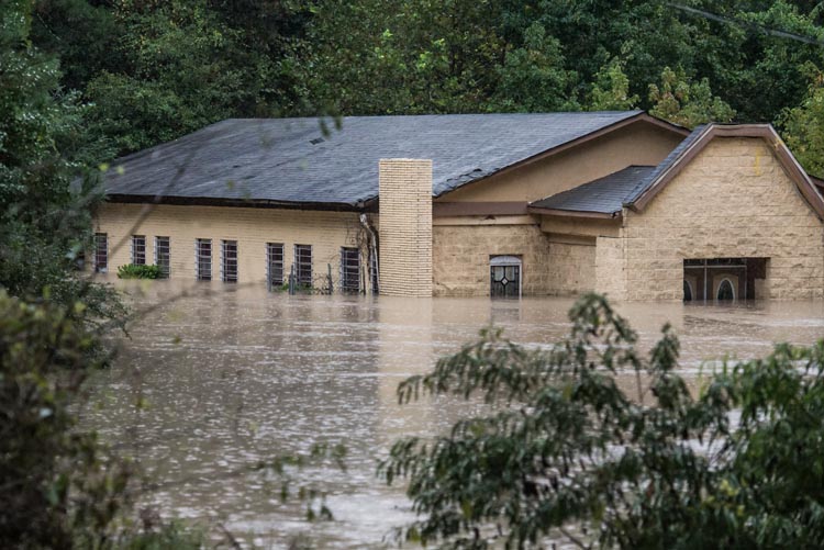
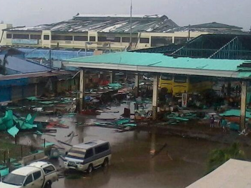
Patricia made landfall as a category five hurricane southeast of Puerto Vallarta, near Cuixmala on Friday evening. Thankfully no deaths had been reported yet out of Mexico as of this morning but significant damage occurred along the coast near La Manzanilla which was both a result of storm surge and the strong winds. After encountering land and terrain Patricia’s inner core quickly collapsed and the system’s biggest threat has now shifted to heavy rainfall. Patricia’s moisture plume is expected to move northeast, helped by an upper level trough, across the Sierra Madres and into southeast Texas. A dangerous flash flooding event is ongoing this weekend in Texas with all the tropical moisture combined with a source of lift present.

South Carolina Floodwaters Recede; Leave Large Amounts of Damage

Over last weekend and the beginning of this week a dangerous flooding situation set up over most of South Carolina.

[map type=”satellite” autofit=”1″ disable_scrollwheel=”1″] [pin]Gills Creek, South Carolina[/pin] [pin]Millwood, South Carolina[/pin] [pin]Kingstree, South Carolina[/pin] [pin]Sumter, South Carolina[/pin] [pin]Columbia, South Carolina[/pin] [/map]

An upper level low which was in place across the southeast CONUS of the United States slowly drifted eastward, but at the same time drew in a tongue tropical moisture into South Carolina where PWATs exceeded 50mm. With much dynamic lift in place provided by the slow moving upper level low, rainfall, which at times very heavy, persisted between October 2nd and the 5th. By the 6th most of the rainfall had finally dissipated and the disturbance had moved out to sea.

A tongue of precipitable water over South Carolina exceeding 50mm Saturday last weekend.

The hardest hit areas comprised of an area along the South Carolina coast extending inland around Charleston and northwest from there. Here, it was common to see storm amounts exceed 500mm. This event broke numerous all time (one, two and three day) rainfall total records including in South Carolina’s capital Columbia which recorded 291mm from the event and a one day, all time, record of 175mm. With all things considered this was a historical event for South Carolina. Unfortunately widespread flash flooding occurred with this heavy rainfall and 17 people perished, it is also expected that this natural disaster will top $1 billion dollars in damages.

Church underwater in South Carolina. (Souce: Sean Rayford via Jeff Master's blog)
Church underwater in South Carolina. (Souce: Sean Rayford via Jeff Master’s blog)

Here are a few more notable amounts from the event (data from NWS):

  • Gills Creek, SC storm total of 546mm
  • Seven stations with over 50 years of data had their wettest October on record, only one week into the month (via weather.com)
  • Millwood, SC storm total 527mm
  • Kingstree, SC 24-hour total of 399mm, possibly beating the all-time South Carolina 24 hour precipitation record of 376mm from 1999 during Hurricane Floyd (via weather.com).
  • Sumter, SC storm total of 528mm

This weekend more soggy weather is in place for South Carolina and flood warnings/flash flood watches have already been issued by the NWS. Not as much rain is expected from this system as it is faster moving and PWATs are not quite as high as seen last week. The one bit of good news that has come out of this flooding is that all moderate drought that was in place has been wiped away from the state.

Elsewhere in Weather News: November 9th, 2013

Super Typhoon Haiyan Plows into Philippines

One of the strongest storms ever recorded on the planet formed this week in the Western Pacific and eventually made landfall over the Philippines on Thursday. Early estimates from satellite data suggest that this super typhoon was the fourth strongest ever recorded and strongest to make landfall, since record keeping began.


Impressive image of Haiyan Thursday afternoon as it neared peak intensity, about 5 hours before making landfall. Extremely cold cloud tops can be seen around the eye. (Source: Co. State University)

Haiyan brought just about every type of severe weather you could experience with a typhoon; extremely strong winds with central pressure below 900mb, very heavy rains causing flooding and a powerful storm surge. The category five typhoon brought intense sustained winds in the order of 300km/h, gusting to over 350km/h and a storm surge of over 15 feet. Reports of damage are still coming in as of Friday night as communication to the islands hardest hit has been knocked out. Tacloban, a city of about 215,000 residents looks to be the hardest hit where damage is significant, storm surge swamped first and second floors of buildings and high winds tore apart buildings. It’s difficult to put an estimate on damage and death toll at this point.


Picture of some of the damage to a bus terminal in Ormoc City (located south-west of Tacloban). (Source: R. Deleon)

Haiyan continues its trek this weekend as it moves over the South China Sea towards Vietnam. It is expected to make landfall on Saturday overnight as a category two typhoon. Haiyan’s passage over the Philippines weakened its inner core as well as slightly cooler sea surface temperatures and higher shear values have all contributed to Haiyan’s slow weakening. Regardless, the typhoon still needs to be watched closely as it approaches Vietnam as flooding and landslides are expected to be a big problem.

Footage of super typhoon Haiyan making landfall in the Phillipines
An update on Haiyan as well as an update on the cleanup in the Philippines will be posted later this weekend.

Elsewhere in Weather News: August 10th, 2013

Potent Heatwave Strikes China; Possible Typhoon on the Way

A prolonged heatwave has been in place for this whole week and even a part of last week over most of Eastern China, including the megacity of Shanghai. An upper-level ridge centered directly over Shanghai (but covering the whole region) is contributing to abnormally high temperatures in the region. Scorching heat, ranging from the high thirties to low forties, covered the whole region while remaining in place yesterday. Numerous heat alerts were issued by the Chinese government urging residents to limit outdoor activities, spend time in air conditioned buildings and most importantly, to stay well hydrated. Unfortunately the death toll had risen to 10 people as of Friday, with Shanghai hardest hit.

China surface temperatures

Map of Eastern China’s surface temperatures for today at 4pm, dark orange is over 36 degrees Celcius. (Source: Wunderground maps)

Such a potent heatwave in this region is not common – it has been said that this one is the worst in 140 years. On August 7th Shanghai broke its all-time record temperature, recording an official high of 40.8°C. Before the recent heatwave began, the highest temperature ever recorded in Shanghai was 40.2°C set in 1934. Shanghai’s average high temperature for August is 32°C. Drought concerns are now coming into play as water sources are starting to run low in the east-central region of China where little to no rainfall is expected in the coming week while the heatwave continues.

The southern coast of China could be under the gun for some drenching rains associated with an incoming typhoon: Typhoon Utor. Utor has still not passed over the Philippines but it is expected to make landfall to the northeast of Manila as a category two. Following its first landfall, it will continue travelling into the South China Sea though there is still a lot of uncertainty as to whether it will curve north into China’s mainland or simply brush the south coast.

Utor

Infrared satellite image of Utor on Friday evening, and it’s expected track. (Source: CIMSS)