Winter’s Last Gasp

This week will see one last wintry blast in southern Manitoba before spring finally arrives for good.

A surface ridge of high pressure will bring cold weather to southern Manitoba to start the week

Monday

Monday
-7°C / -18°C
Mainly sunny. Chance of flurries.

Today will likely be the coldest day of the week. High temperatures will be in the upper minus single digits, with a chance of flurries. This chance of flurries will arise from low-level instability that will develop as the surface warms during the day. To top it all off, there will be a breezy north-west wind – great!

Tuesday

Tuesday
-5°C / -15°C
Increasing cloudiness. Slight chance of flurries.

A low pressure system will pass to our south on Tuesday, allowing a cool north-easterly flow to remain established over southern Manitoba. Luckily, that system should remain far enough south to prevent us from seeing any more snow, although a couple of flurries can’t be ruled out.

Wednesday

Wednesday
-4°C / -17°C
Mix of sun and cloud. Chance of flurries.

A brisk northerly flow will remain in southern Manitoba on Wednesday, making for another cold day. High temperatures will be in the mid minus single digits, and there will once again be a chance of flurries.

Record Cold?

With the cold weather that’s expected this week, we will be challenging some cold weather records. The table below shows the record values for the next several days:

Record Cold Minimum and Maximum Temperatures
Date Record Low Record Cold High
Monday April 14 -16.7°C (1893) -7.8°C (1880)
Tuesday April 15 -16.7°C (1893) -6.7°C (1875)
Wednesday April 16 -16.7°C (1875) -4.4°C (1910)
Thursday April 17 -13.3°C (1953) -3.3°C (1953)

It looks like we will come close to setting new records on each of the days listed in the table. Stay tuned to see if we manage to actually break any records!

Long Range

The long range forecast calls for increasing temperatures as we move into the weekend. We’ll likely see seasonal temperatures (i.e. low teens) return by the weekend into next week. There is currently no strong prospective of above-normal weather, but we’ll probably see at least a couple seasonably warm days before the month is out.

Record Low Temperatures Broken

A large swath of record low temperatures were set on the morning of April 15, 2014 across the province of Manitoba thanks to a strong Arctic ridge of high pressure sprawled over the region. Overnight lows were 10-20°C below normal throughout the province. Winnipeg did not set a new record low, however some other locations in the Red River Valley did.

Record Low Temperatures set on April 15, 2014
Site New Record Old Record (Year)
Berens River –23.8°C –19.6 (1997)
Carberry –14.2°C –12.9 C (2000)
Carman –15 C –11.4 C (2000)
Fisher Branch –20.4 C –11.8 C (2000)
Flin Flon –20.5 C –16 (1997)
George Island –19.5 C –16.8 C (1997)
Grand Rapids –24.4 C –13 (1997)
Island Lake –20.7 C –20.6 C (2000)
McCreary –13.7 C –12 (2000)
Oak Point Marine –19.7 C –11.9 (1997)
Pinawa –21 C –12 (2000)
Roblin –11.4 C –11.3 C (1997)
Shoal Lake –11.5 C –10.2 C (2000)
Sprague –16 C –10.8 C (2000)
The Pas –20.5 C –18 C (1986)
Thompson –27.3 C –23.4 C (1985)
Victoria Beach –20 C –11 C (2000)
Wasagaming –15.5 C –15 C (1978)

More record lows will be at the risk of being broken as the week progresses.

Cool Nights Ahead, Otherwise Seasonal

We’ll see fairly seasonal weather over the weekend with overnight lows that will start off cool but climb back towards normal as well.

700mb Temperatures for Saturday Morning

700mb temperatures from the GEM-REG for Saturday morning. A significant pool of cold air remains entrenched over NW Ontario, while warm air builds over Alberta and struggles to push eastwards.

After quite a chilly evening last night, temperatures will climb nicely today towards a high of about 25°C. We’ll see mainly sunny skies today and clear skies tonight as we head down to a low of around 8°C. Tomorrow morning we’ll see some cloud as a weak disturbance travels south through the Interlake with a slight chance of a shower before things clear out midday and we’re left with sunny skies and a high a little cooler near 23°C as more cool air filters down behind the morning’s system. The weekend will close out with another sunny day with a high climbing a little bit higher into the mid-to-upper 20’s.

The next chance of precipitation looks to possibly be on Tuesday morning, however the risk is marginal and currently looks like the system will remain to the north of the Red River Valley.

2012 One of the Hottest Years on Record

We covered just how warm July 2012 was a couple posts ago, but what’s shaping up to be an even bigger story is just how hot 2012 as a year is. Last week, Jeff Masters covered how 2012 is shaping up to be the hottest year ever in the contiguous United States and included an image from NOAA that showed average yearly temperatures through the climate record, highlighting the top 5 and coldest 5 years on record:

Year-to-Date Temperature Anomolies for Contiguous U.S.

Year-to-date temperature anomaly, by month, for 2012 (red) compared to the other 117 years on record for the contiguous U.S., with the five warmest years (orange) and five coldest years (blue) noted.

With plenty of warm records having been broken over the past year, and the fact that we’re going on 13 consecutive months with above-normal temperatures, I thought it would be interesting to see what such a chart looks like for Winnipeg.

Methodology

First I calculated the monthly mean temperatures for the entire climate archive for Winnipeg, which covers March 1872 – July 2012. I then calculated year-to-date normal temperatures for each month from 1901 to 2010 to use as a “20th Century Average”. For example, March’s YTD average was calculated simply by:

    March Average = AVERAGE(JAN Average + FEB Average + MAR Average)

To calculate the temperature anomolies, I did a similar process on the monthly mean temperatures for each year, calcluating a YTD value for each month, then simply subtracted that from the associated month’s 20th century average. This process produces the signature tapered look on the above chart, where the large variability from year-to-year evident in January smooths out to nice, clean lines by the end of the year.

Results

The results for Winnipeg are startlingly similar to the United States:

Year-to-Date Temperature Anomolies for Winnipeg, MB

Year-to-date temperature anomaly, by month, for 2012 (red) compared to the other 139 years on record for Winnipeg, MB, with the five warmest years (orange) and five coldest years (blue) noted.

It’s quickly evident that 2012 is on track to end as one of the warmest years on record. The current top 5 warmest years are:

Rank Year Year-End Temperature
Anomaly
1 1987 +2.93°C
2 1931 +2.80°C
3 1878 +2.20°C
4 1998 +2.14°C
5 2006 +2.00°C

This year’s current YTD temperature anomaly is sitting at +3.13°C. This beats out 1987’s year-end anomaly of +2.93°C, however is less than the value calculated at the same time of year (July), which was +4.02°C. We’ve started August off right near-normal, however ensemble outlooks have us returning to slightly above-normal temperatures fairly soon.

A Return to More Seasonal Weather

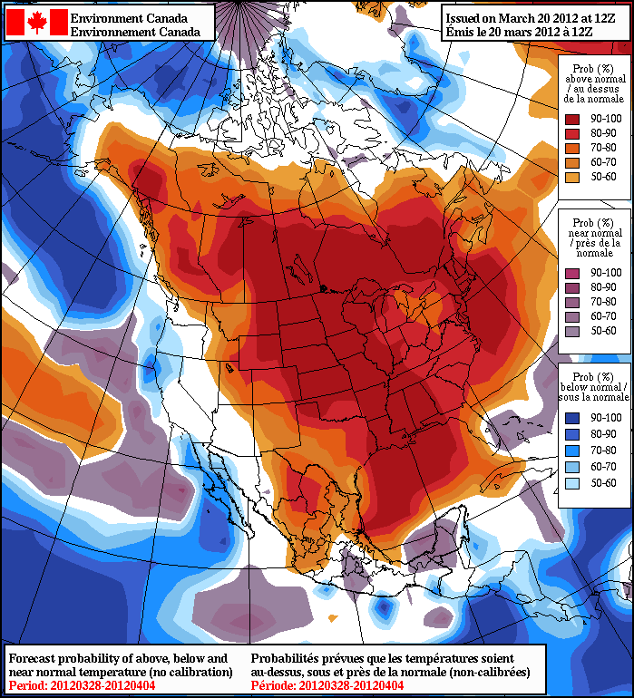
The unbelievable March heat wave is coming to an end in Southern Manitoba as the blocking pattern that has been maintaining record-obliterating heat throughout much of Central and Eastern North America begins to break down. This will cause us to return to a slightly more unsettled and seasonal pattern, albeit temperatures will still remain (for the most part) above normal for this time of year.

Heat Wave Shatters Records

Temperature Anomalies March 8-15

The intensity and scope of Summer in March is clearly visible in this data from the MODIS instrument on the Terra satellite. Areas with warmer than average temperatures are shown in red; near-normal temperatures are white; and areas that were cooler than the 2000-2011 base period are blue. Image credit: NASA Earth Observatory.

The March 2012 heat wave has shattered records all across North America, with thousands of temperature records being broken across the United States and Canada. Pellston, Michigan broke their daytime high record for March 21 by an absurd 32°F, a temperature that was 48°F above average. In St. John, NB, their daytime high of 25.4°C on March 21st was warmer than any day they’ve ever had in April. Halifax, NS
also had a warmer day yesterday than any day on record in April with their high of 28°C. The list goes on and on, but it seems that almost anywhere you go east of the Rocky Mountains has set numerous records and is experiencing weather that’s arrived at least a month early, if not a couple! The image above illustrates exactly how substantial the warm weather has been; it shows the departure from the 2000-2011 normal for land temperatures for March 8-15th. The reds show just how wide-spread and substantial the heat wave has been!

Winnipeg has broken numerous records over the past 12 days, including:

  • 8 daily record high temperatures (11, 12, 15, 16, 17, 18, 19, 22)
  • Earliest 20°C reading on record (March 18)
  • Warmest overnight low in March (14°C on the night of March 18/19)
  • Earliest thunderstorm on record since 1953 (Evening of March 19th)
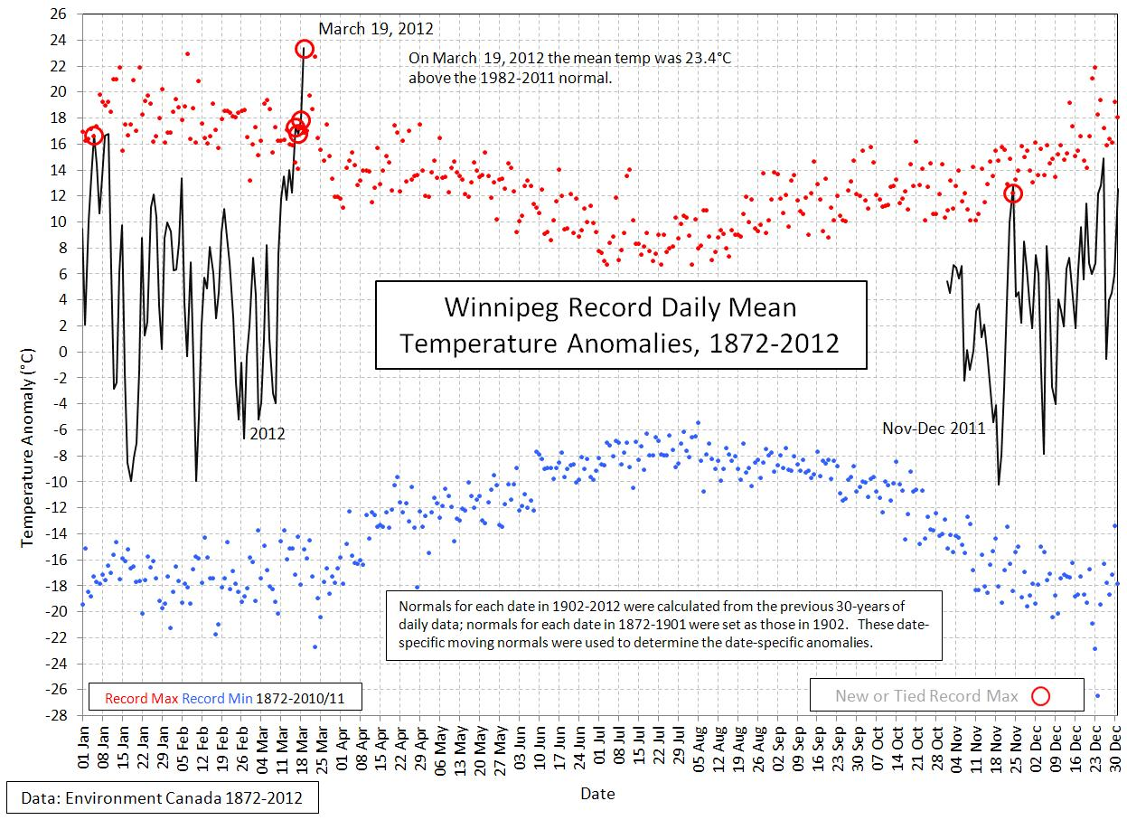
  • Warmest March day on record (March 19th, 23.7°C)
  • Most significant departure from normal temperature for any day of the year (+23.4°C above normal on March 19th)
  • 4 consecutive days over 19°C (Only 4 days since records began have reached that mark. From Rob’s Blog: In other words, it took only 4 days during this warm spell to match what took 140 years to accomplish.)

Records that will need to happen yet and need to be verified:

  • Warmest March on Record (Currently sitting at a mean temperature of 0.4°C, record is 1.6°C set in 1878).
  • Highest dew point in March (17°C on March 19th, need to finish parsing data set to verify)

The past week and a half has truly been an extraordinary weather event that has not been seen in the lives of 99% of the people who will read this. As the next weather system moves through, we’ll see a transition it a more seasonal weather pattern that will return us to closer-to-normal temperatures and bring with it some unsettled weather.

Upcoming Weather

Accumulated Precipitation

Accumulated Precipitation from 18Z Mar. 22 to 00Z Mar. 24 (Thursday Afternoon to Friday Evening)

A somewhat complicated scenario presents itself for Winnipeg over the next couple days. Overnight, the cut off low that has been anchored over the Southern Plains of the US has been working NE and has pushed it’s deformation zone into Southern Manitoba, spilling clouds northwards. There’s a chance we’ll see a light shower early this morning in Winnipeg, however most models keep the precipitation to our south (including the GEM-REG, pictured above. There will be a few scattered showers through the RRV through the morning, with a better chance of measurable precipitation east of the Red River. The precipitation will move out by the afternoon, however we won’t lose the cloud. This will limit our temperature to 19 or 20°C. If we’re able to get a couple hours of sunshine today (unlikely), we’ll definitely have a shot at breaking the daily record high of 22.8°C.

As the low pulls off to the east, instead of clearing out with a northwest wind, we’re left in a slack flow as another system ejects northeastwards out of Montana. It will approach Manitoba on Friday night and cross the province through the Interlake on Saturday. As it moves across Saskatchewan on Friday night, it will pull much of the moisture in Southern Manitoba northwards as a warm front lifts out of North Dakota. Saturday morning will be a toss up…some models want to clear out the cloud and give us a nice sunny day, however I think that our proximity to the lift associated with the low, the cap we’ll have as we’re in the warm sector of the system, and the moisture present in the low-levels will keep us on the cloudier side of things until the cold front passes through around lunch time. We’ll clear out with the cold front and have our coldest night in what seems like forever now with an overnight low around -5°C.

Sunday will be a fairly nice, albeit crisp, day with sunny skies and a daytime high in the high single digits. While this temperature will certainly feel cold, it will still be 5°C+ above the normal daytime high.

The most significant precipitation event since the beginning of March looks to be shaping up for Monday night through Tuesday; it’s still early, though, so we’ll keep you updated in the comments on this post and have a good look at it in Monday’s post.

And last but not least, happy World Meteorological Day everybody!


Table of Broken Temperature Records (Winnipeg)

Day New
Record
Old
Record
Previous
Record Year
Sun Mar. 11 12.8°C 12.5°C 1981
Mon Mar. 12 9.7°C 7.2°C 1922
Thurs Mar. 15 14.4°C 11.1°C 1927
Fri Mar. 16 19.9°C 12.4°C 1981
Sat Mar. 17 19.2°C 12.8°C 1938
Sun Mar. 18 20.9°C 14.4°C 1910
Mon Mar. 19 23.7°C 18.9°C 1938
Thurs. Mar 22 21.7°C 18.3°C 1878
Table of daily record high temperatures during the March 2012 heat wave from March 11, 2012 to March 22, 2011.

March Heat Wave Continues

Last week saw Winnipeg bathing in historically abnormal warm weather that shattered numerous daily record high temperatures as well as breaking the record for the warmest day in March since 1872. Thunderstorms then pushed through Winnipeg Monday night, lighting the city up with intense lightning and settling the dust with 10-15mm of rain. On the back side of these storms, cooler air pushed over Southern Manitoba, giving us a daytime high yesterday around 13°C cooler than Monday, which amazingly was still ~10°C above normal for this time of year. Despite the “cool” day, the heat wave isn’t over yet, with temperatures set to rebound to threaten more daily high temperature records over the next few days.

Temperature Records Smashed

Day New
Record
Old
Record
Previous
Record Year
Sun Mar. 11 12.8°C 12.5°C 1981
Mon Mar. 12 9.7°C 7.2°C 1922
Thurs Mar. 15 14.4°C 11.1°C 1927
Fri Mar. 16 19.9°C 12.4°C 1981
Sat Mar. 17 19.2°C 12.8°C 1938
Sun Mar. 18 20.9°C 14.4°C 1910
Mon Mar. 19 23.7°C 18.9°C 1938
Table of daily record high temperatures over the from March 11, 2012 to March 19, 2011.

Winnipeg saw unprecedented heat for the middle of March which broke daily high temperature records on 7 of 9 days. Many records were broken by at least 5°C, and temperatures peaked on Monday, March 19 at 23.7°C, which broke the record high temperature for that day by 4.8°C and broke the old record for the hottest day in March in Winnipeg of 23.3°C set on March 27, 1946. On Sunday, March 18th, Winnipeg had a high of 20.9°C, which was the earliest 20°C reading on record.

Since Friday, Winnipeg has recorded 4 straight days over 19C. In the previous 140 years of March records, that mark has been reached on only 4 occasions in Winnipeg. In other words, it took only 4 days during this warm spell to match what took 140 years to accomplish.
Rob’s Obs Blog

Perhaps even more impressive was how far above normal temperatures have been. Typically, for the second week of March, normal daytime highs are around -1°C to 0°C. With temperatures rocketing into the high teens, Winnipeg spent almost an entire week with temperatures at least 15°C above normal.

Temperature Anomolies

Winnipeg Record Daily Mean Temperature Anomalies, courtesy Danny Blair – University of Winnipeg

In fact, as the above graph shows, Winnipeg set a new all-time record for temperature anomaly. On March 19th, the daily mean temperature was 23.4°C above normal, which was a higher value than any other day of the year. Winnipeg had never been so far above normal temperatures as Monday.

The Weather This Week

So what’s in store? After a cool Tuesday, temperatures are set to rebound today and tonight, with milder air once again pushing into our region. Today will bring plenty of sunshine with a breezy southwest wind around 30km/h and a high of 14°C. A warm front will push northwards through Southern Manitoba on Thursday, bringing a mix of sun and clouds and temperatures in the upper teens. This warmth will once again bring us the chance of breaking more daily record high temperatures. Currently, Thursday currently looks to be the most likely day we may break a record high temperature. For the next few days, the daily record high temperatures are:

Day New
Record
Old
Record
Previous
Record Year
Wed Mar. 21 ??.?°C 19.4°C 1938
Thur Mar. 22 ??.?°C 18.3°C 1878
Fri Mar. 23 ??.?°C 22.8°C 1910

How about the long term? Ensemble guidance continues to smother central and eastern North America with 90-100% chances of temperatures being above normal.

Anomaly Outlook

NAEFS 8-14 Day Temperature Anomaly Probability Outlook, valid March 28 – April 4.

With probabilities that high, while we may have a chilly day here or there, we’ll be hopping right towards summer with little risk of a disheartening return to winter.