Another Day of Record Highs, Then…Winter.

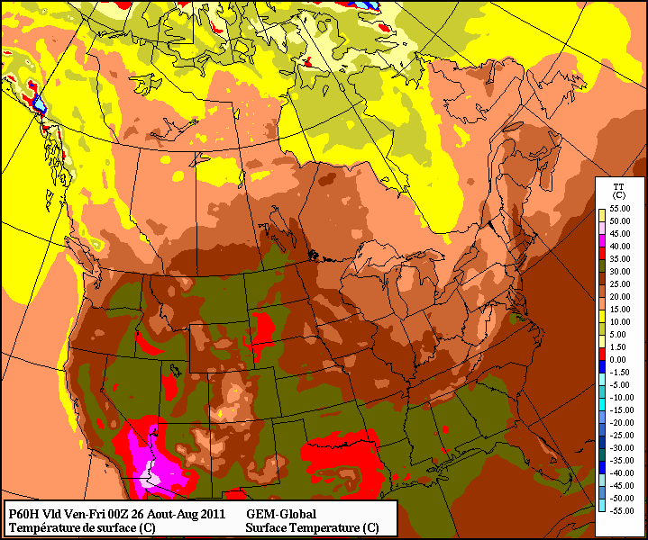
Winnipeg has enjoyed 32 consecutive days with above average temperatures, making this one of the more pleasant winters in recent memory. This is about to abruptly change as winter is making an ungraceful return tonight. Before that, however, is another beautiful day with a good chance that more daytime temperature high records will be broken.

2012-01-10 21Z Surface Prog.

Jan. 10, 2012: 21Z (3PM) surface prognosis from the GEM-REG. Blue line represents cold front, red line represents the warm front.

This afternoon will bring more record-setting temperatures to southern Manitoba as the area is drenched in one last shot of Pacific air. By mid-afternoon, Winnipeg will be firmly in the warm sector, and with 850mb temperatures of 2 or 3°C, temperatures should reach as high as 6 or 7°C through a majority of the RRV, Winnipeg included. There is a slight chance that some areas close to the western escarpment of the RRV could see another day of 9 or 10°C with the extra push from downslope winds and their continued lack of snow cover. That being said, I fully expect daytime high records to be broken in many communities in the RRV today.

Tonight, however, is a whole different story.

Winter Returns

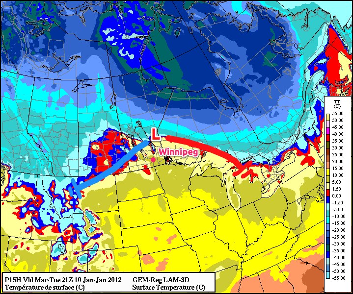
After being held well to our north for over 4 weeks, Arctic air will surge across the Prairies today and tonight, bringing a drastic change to the weather. The cold front will sweep through Winnipeg between 00Z and 03Z (6PM & 9PM, respectively), ushering strong northwest winds and much colder air. Much of the southern Prairies will see snowfall with this system, with areas closer to the international border receiving 2-4cm. Winnipeg will be near the northern fringe of the snowfall, but I think that we’ll see at least 2cm of snow here. I think that 5cm is very unlikely, but there is still some uncertainty in how intense the band of snow will be. The most significant snowfalls will occur through the Northern Interlake, where they’ll be under the influence of a hang-back trough from the main low pressure system, bringing them snow for a longer period of time than us in the southern portions of the province.

2012-01-11 15Z 850 Wind Prog

Jan. 11, 2012: 15Z (9AM) 850 wind prognosis from the NAM

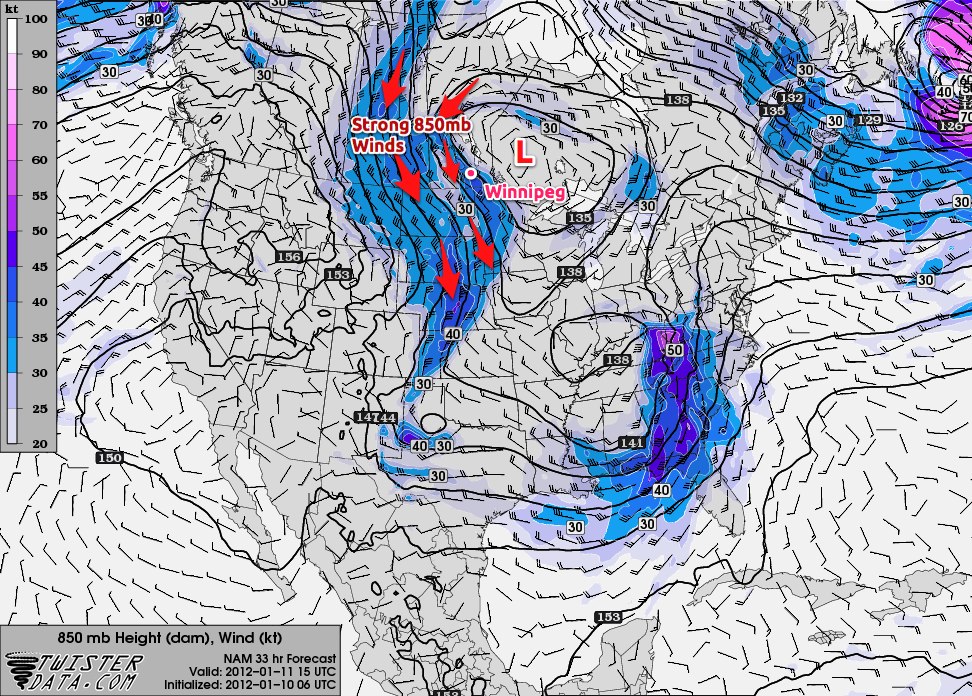
With winds at 850mb forecast to be 30-40kt, surface winds have the potential to gust as high as 70km/h overnight. Likely, we’ll see a period of sustained winds near 50km/h before things settle out with sustained winds near 40km/h with gusts to 60km/h. Combined with temperatures that should fall to near -15°C tomorrow morning, wind chill values will be as low as -25 overnight.

2012-01-12 06Z 850 Temp Prog

Jan. 12, 2012: 06Z (Midnight) 850mb temperature prognosis from the NAM

A second cold front will pass through the RRV between 15Z and 18Z tomorrow morning (9AM and Noon), reinforcing the strong winds and causing temperatures to either remain steady or drop through the afternoon. The gusty northwest winds should continue through the whole day, with some light flurries and temperatures that will start near -15°C and drop to close to -20°C by evening. These temperatures combined with the wind should result in wind chill values near -30 for most of the day.

Normal daytime highs for this time of year are around -13°C and normal overnight lows are around -24°C. For the first time in over a month, Winnipeg will experience below-normal temperatures.

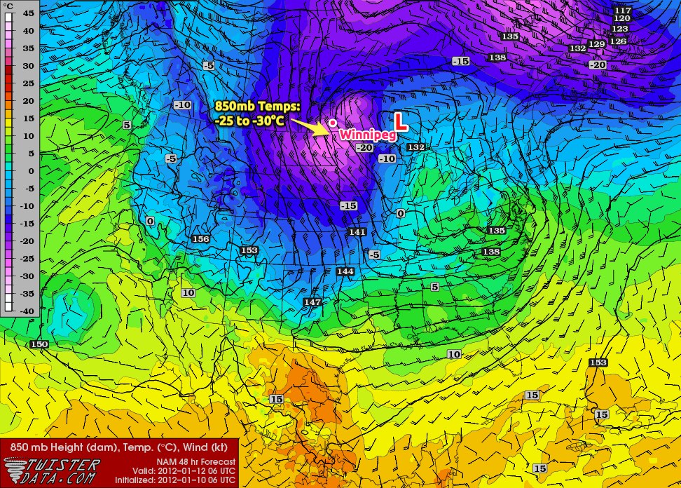
Extremely cold air at 850mb will move over the southern portion of the province Wednesday night; with 850mb temperatures in the -25 to -30°C range, we can expect overnight lows close to -25°C for Wednesday and Thursday night, with a daytime high on Thursday barely above -20°C. The GEM-REG is a little warmer than the NAM on the cold air moving over the RRV, so there is a chance of temperatures being a couple degrees warmer than this, but I’ll always bet on the cold air.

Fortunately, it looks like the cold weather will be relatively short lived. Current indications are that another low tracking across the Prairies should push warmer air into Winnipeg for the weekend, with daytime highs near -5°C. More on that later in the week.


UPDATE: 6 records fell again today across Manitoba as most places enjoyed yet another mild day.
td { text-align: center; }

Location New
Record
Old
Record
Old Record
Year
Fisher Branch 4.9 2.4 2002
Gimli 4.7 3.0 1990
Gretna 7.5 2.6 2006
Melita 4.3 2.5 2002
Pinawa 6.5 3.5 1990
Winnipeg (Tie) 5.1 5.1 1990

Record Setting Heat Across the Prairies

Summer has decided to hang on and not leave us quite yet, bringing record-breaking heat to much of the Canadian Prairies. A large upper ridge build into the region on Tuesday and Wednesday, pushing the jet stream all the way up to the 60th parallel which has allowed a hot, dry southwest flow to remain in place over Alberta, Saskatchewan and Manitoba for days on end. Records have fallen left in right, with some of the highest daily quantities of records being broken at once over the last two days.

How long will this heat stay with us? How hot is it going to get? Click through to read more!

On Wednesday, September 7th, 22 record highs were broken across Alberta, Saskatchewan and Manitoba:

Daily Record Temperatures set September 7, 2011

Location New
Record
Old
Record
Record
Year
Records
Began
Alberta
Cold Lake 30.4 27.8 1998 1953
Fort Chipewyan 27.0 25.0 1937 1884
Fort McMurray 31.0 28.3 1949 1944
Jasper 29.6 29.1 1998 1943
Whitecourt 29.1 26.7 1949 1943
Saskatchewan
Saskatoon 33.4 31.5 1990 1892
Collins Bay 28.0 18.8 1980 1972
Hudson Bay 30.7 30.2 1990 1943
Key Lake 30.0 21.5 2005 1977
La Ronge 29.6 27.7 1980 1923
Meadow Lake 30.2 28.5 1998 1924
Melfort 31.7 31.5 1980 1902
Nipawin 33.0 32.2 1934 1927
North Battleford 33.0 32.2 1893 1880
Rosetown 32.6 32.0 1991 1937
Stony Rapids 27.0 22.7 2005 1960
Manitoba
Fisher Branch 29.7 29.5 1980 1977
Gimli 28.3 27.9 1980 1944
Lynn Lake 29.0 23.9 1980 1952
The Pas 30.3 29.4 1934 1910
Thompson 27.6 24.5 1990 1967

Of note on this day:

  • North Battleford broke a daily record high temperature that was set in 1893, a record 118 years old.
  • Many record highs were broken by at least 2 or 3°C, and some by nearly 10°C.

On Thursday, September 8th, 22 record highs were broken across Alberta, Saskatchewan and Manitoba:

Daily Record Temperatures set September 8, 2011

Location New
Record
Old
Record
Record
Year
Records
Began
Alberta
Cold Lake 30.8 29.8 1981 1953
Coronation 32.2 31.2 1981 1928
Fort McMurray 32.1 30.4 1981 1944
High Level 27.4 26.3 1995 1967
Jasper 30.0 29.8 1998 1943
Sundre 26.9 26.0 1994 1985
Waterton Park 28.3 28.0 1994 1966
Saskatchewan
Saskatoon 34.1 33.5 1981 1892
Collins Bay 24.6 24.1 1981 1972
Hudson Bay 31.7 30.2 1990 1943
Kindersley 33.2 32.8 1981 1913
Leader 34.2 33.5 1981 1924
Nipawin 32.8 32.2 2003 1927
Stony Rapids 24.1 22.3 2003 1960
Manitoba
Fisher Branch 32.1 32.0 2003 1977
Gimli 31.1 30.0 2003 1944
Island Lake 28.1 25.2 2009 1971
Lynn Lake 26.6 23.6 1980 1952
Pinawa 30.7 30.5 2003 1964
Sprague 30.9 29.4 1932 1915
The Pas 30.3 27.5 2003 1910
Thompson 28.0 25.8 2003 1967

And today, September 9th, 2011, 18 records were broken:

Daily Record Temperatures set September 9, 2011

Location New
Record
Old
Record
Record
Year
Records
Began
Alberta
Edson 28.7 27.8 1963 1910
Fort Chipewyan 30.0 27.0 1981 1884
Fort McMurray 32.7 32.4 1981 1944
Jasper 30.4 27.2 1944 1943
Sundre 28.9 25.8 2006 1985
Waterton Park 28.5 27.4 2006 1966
Whitecourt 29.7 29.0 1981 1943
Saskatchewan
Collins Bay 28.0 23.0 2003 1972
Hudson Bay 31.7 29.0 1998 1943
La Ronge 31.0 26.6 1994 1923
Nipawin 32.1 29.2 1981 1927
Stony Rapids 29.1 22.0 2006 1960
Manitoba
Fisher Branch 31.8 31.5 1982 1977
Gimli 31.1 31.0 1982 1944
Lynn Lake 31.1 26.6 2003 1952
Sprague 31.9 30.0 1931 1915
Swan River 31.7 30.0 1998 1908
The Pas 30.7 26.8 2003 1910

This record-setting heat is all thanks to an impressive upper ridge that has built into the Prairies. This is a feature located high in the atmosphere that causes a large area of air to subside (move downwards). Combined with the fact that they build up from the south, they bring a lot of warm air along with themselves, and often result in a large area seeing sunny skies, light winds and hot, dry weather.

The upper ridge will remain in our area for the next couple days, with daytime highs remaining in the low 30°C range. Winnipeg has an honest shot at breaking our daily record high temperature tomorrow which sits at 32.4°C. Things will abruptly change next week however. On Monday a low pressure system will pass by to our north and drag a cold front down across the province. Through the following days, a large ridge of high pressure will build in from the northwest, bringing significantly cooler temperatures than the past week:

GFS Temperatures Valid 06Z Thursday 15 Sept
GFS Surface Temperatures Valid 06Z Thursday 15 September

Currently it looks like next Wednesday and Thursday will be the coldest of the days, with highs struggling to get as high as 15°C. While the last week has been a beautiful late-season blast of summer, fall is set to make an aggressive entrance early next week.

Winnipeg Bakes Under Hottest Day In 16 Years; Summer Far from Over

It's a scorcher out there
Winnipeg baking underneath it’s hottest day in 16 years

An extremely warm air mass, combined with brisk westerly winds, brought record heat to much of southern Manitoba. Winnipeg officially reached 37.0C today, breaking the old record of 36.7C set in 1952 and marking the warmest day the city has seen since June 17, 1995 when the mercury soared to 37.8C.

The warm weather spread into Southern Manitoba ahead of a cold front sweeping cooler air into the province by Tuesday evening. A westerly, downslope flow coupled with extremely warm air at 850 mb pushed the mercury to record-breaking levels in many areas across Southern and Central Manitoba, including:

Location New Record Old Record
(Old Year)
Records Started
Winnipeg 37.2° 36.7° (1952) 1873
Fisher Branch 34.2° 31.0° (1990) 1977
Gretna 36.5° 31.1° (1965) 1955
Island Lake 29.1° 27.8° (1976) 1971
Melita 33.3° 32.2° (1997) 1993
Pinawa 35.4° 31.1° (1969) 1964

One thing that was very interesting, though, was that the International Airport in Winnipeg was actually one of the cold spots in the city. Various personal weather stations reported even higher temperatures:

Location Today’s High
Birds Hill Park 38.0°
Charleswood 38.0°
East St. Paul 37.0°
Island Lakes 36.9°
St. Vital 38.8°
Whyte Ridge 37.7°

Fortunately, a cold front passing through this evening will usher in cooler weather and stronger winds. An intensifying surface pressure gradient on the back-side of the cold front will bring strong winds into Winnipeg tomorrow with sustained winds expected to reach 50km/h with the potential for gusts as high as 80km/h. Temperatures will be about 13-15 degrees cooler than today, with highs of 23-25° expected for much of Southern Manitoba.

GEMGLB Temperature for Thursday Afternoon
12Z Aug 23 GEM-GLB Temperature valid 00Z Fri Aug 26

However, after just one cooler day, warmer weather is expected to return to Southern Manitoba. By Thursday afternoon, temperatures should push back up towards the 30° mark with a southerly flow that redevelops through the day. Late Thursday evening a cold front will pass across the RRV, bringing us back into daytime highs of 22-25° for the weekend. Currently, no precipitation is expected with this front, but I’ll keep an eye on it through the week.

Snow For Much of Southern Manitoba Today Into Tomorrow

A system moving through the Northern Plains of the United States will push snow northward across the international border into much of Southern Manitoba, with warning-level amounts in some areas close to the International Border.

Heavy snowfall occurring in Montana is pushing east-northeastward into southeastern Saskatchewan and Southern Manitoba. Heavy snow giving near zero visibilities at times is expected to develop in southern regions near the international border, including the Melita, Pilot Mound, Morden/Winkler, and Emerson regions. Environment Canada has issued Snowfall warnings for the Melita and Pilot Mound/Kilarney regions, with 10cm of snow expected in areas close to the border, and the potential for amounts in excess of 15cm in upslope snowfall areas of Pilot Mound. All sorts of warnings exist for most of North Dakota, so anybody who has to travel south today should take extra precautions and prepare for extremely poor driving conditions.

For Winnipeg, the snow will push into the city mid-to-late afternoon and stick around for 18-24 hours. Thoughts based of previous model runs would have been for just some light non-accumulating snow, even taking into account that all models were keeping this system too far south. The new GEM-REG run has, however, pushed the system (in my opinion, correctly) further North and is bringing more substantial snow into the Winnipeg area.


GEM-REG 24H Cumulative Precipitation valid 12Z Tuesday 21 Dec. The heavier snow expected along the International Border and through North Dakota is the dark-ish green shading, indicating 7-10mm of liquid equivalent precipitation. This covers Monday morning to Tuesday Morning.

While we won’t deal with the extremely poor traveling conditions of our neighbours to the south, we will see accumulations of 2-4cm when all is said and done. South of the city, amounts of 5-10cm should pile up. The bulk of the precipitation will pull out of the province overnight, however there will be a weak trough that hangs back through the RRV and southeastern Manitoba that will continue to produce light snow through much of the day tomorrow.


GEM-REG 24H Cumulative Precipitation valid 00Z Wednesday 22 Dec. This shows the precipitation expected to occur Monday evening through Tuesday evening. Light snow, without significant accumulation, is expected to occur through much of southern Manitoba through the day on Tuesday.

After this system, we should have a fairly pleasant rest of the week, with highs just above or near -10C and lows in the low minus teens.

Another small point of significance to this event is that it may be one of Winnipeg’s last chance to break the record for wettest year ever. The current record is 723.6mm from 1962. We currently sit in 3rd wettest year ever at 716.0mm, with second place only a hair ahead of us at 718.4mm (which was from 1953). We need only another 7.7mm to break the record, and this system, in a worst case scenario could give us something in the 4-6mm range.

Worth noting, is that in many of the wettest years ever, a major flood did not occur in the following spring; just shows how the melt rate and spring precipitation are the most crucial aspects in our annual floods.