Mild Week Ahead

For the first time in a long time we’re in for an extend period of mild weather, sounds nice doesn’t it!

A surface high will bring pleasant conditions to southern Manitoba on Monday

Monday

Monday
9°C / -2°C
Mainly Sunny

Today will feature slightly below seasonal temperatures in southern Manitoba. Highs will range from the low teens in south-western areas, to upper single digits in the Winnipeg region. We’ll be under a surface ridge of high pressure, which should keep winds relatively light and skies relatively clear.

Tuesday

Tuesday
14°C / 4°C
Mainly Sunny

Tuesday looks to be another nice day in southern Manitoba. Temperatures should be near to slightly above-seasonal, meaning high temperatures in the low to mid teens. The wind will begin to increase late in the day, particularly over western Manitoba, as a developing weather system approaches the region.

Wednesday

Wednesday
9°C / 4°C
Mainly Cloudy. Chance of Rain.

Wednesday will see mild weather continue, with temperatures in the upper single digits, although we may get a bit wet. That developing weather system noted for Tuesday will spread rain, or even snow, into Manitoba on Wednesday. It’s too early to say where the main impacts of this storm will be, but it looks to become a fairly major storm for some part of Manitoba. Some of the current models take the storm up into Central Manitoba, while others take it through southern Manitoba. Areas to the north of its track could potentially see heavy snow, while areas to the south will see rain. As more certain information about this storm is available, we’ll be sure to let you know.

Long Range

The long range forecast suggests we’ll generally see normal to slightly-below normal weather to close out the month of April. That means high temperatures generally near the 10°C mark. While 10°C is nothing spectacular for this time of year, it certainly sounds ok given how awful the last several months have been.

Cool and Calm

The weather this week will be cool and calm, meaning no big weather makers are in the forecast.

Early Week

Monday

Mix of Sun and Cloud. Slight Chance of Flurries.
4°C / -1°C
Tuesday

Mainly Cloudy
2°C / -8°C
Wednesday

Mainly Sunny
0°C / -8°C

Monday will be a seasonably warm day in Southern Manitoba. A cold front will pass through in the morning, causing the wind to shift to westerly. Temperatures will be in the low to mid single digits.

Tuesday should see seasonable conditions continue in Southern Manitoba. Temperatures will be in the low single digits with a light westerly wind.

Wednesday will be very similar to Tuesday, with temperatures once again in the low single digits and winds being light.

Long Range

The long-range forecast looks to feature mostly seasonal weather. However, we’ll likely see our first snowfall of this fall at some point in the next 5-10 days. It probably won’t be a significant snowfall, but a snowfall nonetheless.

This Week May Start with a Bang

There will be a risk of strong to severe thunderstorms in Southern Manitoba to start the week – hence why it may start with a bang!

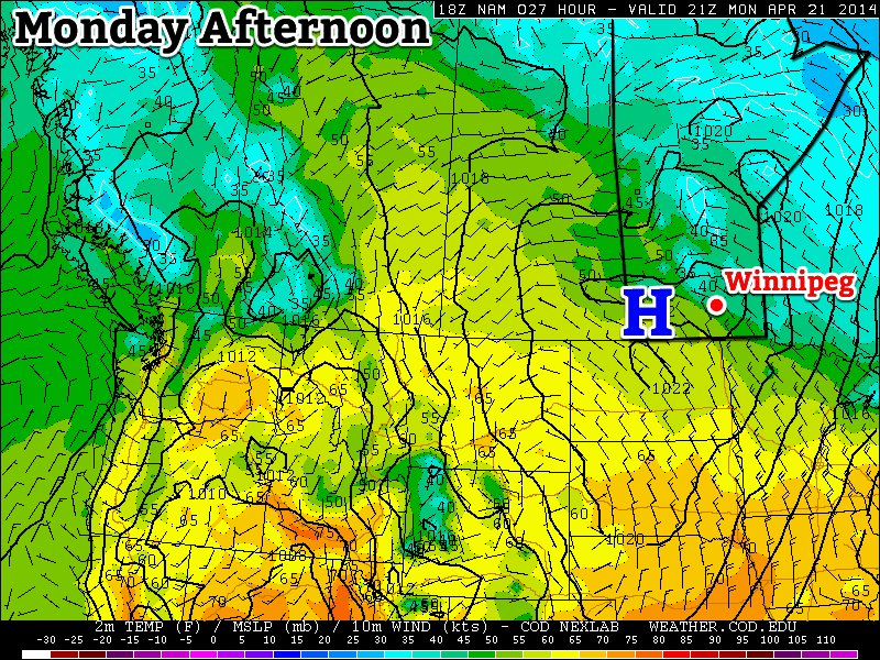
Positions of Fronts on Monday Afternoon

Monday

Monday

Mix of Sun and Cloud. Risk of a Thundestorm.
25°C / 12°C

Today’s weather will be dominated by a risk of thunderstorms in Southern Manitoba. These storms may become severe, with large hail, damaging winds, and heavy rain. Tornadoes will be possible, but the risk is quite low. The reason why thunderstorms are being forecast for today is due to an unstable atmosphere being in place over Southern Manitoba along with a jet stream overhead. When combined, these ingredients can produce strong storms. If you’re in the mood for a more details, please read the technical discussion below.

Technical Discussion:

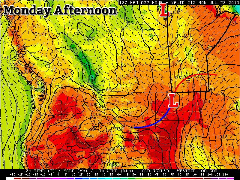
There is a slight risk of severe thunderstorms in Southern Manitoba today. An overview is offered below:

Moisture: Surface dewpoints in the mid to upper teens will be in place over Southern Manitoba by this evening. At 850mb, dewpoints will be around 10C.

Instability: MLCAPEs of 1000-2000J/kg will be in place over the western half of Southern Manitoba this evening. This instability will likely be transported eastward through the rest of Southern Manitoba during the late evening to overnight period.

Wind Shear: 0-6km bulk shear is currently 25-30kts over Southern Manitoba. An upper-level jet at 250mb is in place along the International border, with speeds of around 70kts. In the low-levels a south to south-westerly low-level jet of 20-30kts will be in place this afternoon.

Trigger: A trough will be positioned through the western-most portions of Southern Manitoba today. In addition, models suggest a weak surface low may be located near Portage la Prairie by late evening. A pseudo-warm front will likely extend from this surface low north and eastward through Southern Manitoba during the day. In addition, the left exit of a 250mb upper-level jet will be position over Southern Manitoba during the day today.

Monday’s Thunderstorm Risk Map

Conclusion: There will be a risk of severe thunderstorms today through much of Southern Manitoba. This risk is contingent on sufficient daytime heating, with convective temperatures generally being in the mid-twenties. Should sufficient heating occur, storms should develop along the trough and possibly surface low during this afternoon. Storms will drift east and persist into the evening. Models suggest there will be some useable elevated instability tonight, so storms may persist after dark. However, the timing of storm evolution will be important, since the atmosphere does not destabilize in the Red River Valley, and points east, in a significant fashion until around/after dark. Thus, if storms move eastward too quickly, they may not be in phase with the plume of instability. Therefore storms may begin to weaken by late evening if the aforementioned factors are not in sync. Storms are generally expected to be multicellular in nature, however some supercells will be possible, particularly during the evening hours in south-central Manitoba.

Tuesday

Tuesday

Mix of Sun and Cloud. Slight risk of a Thunderstorm.
24°C / 10°C

The forecast for Tuesday is a somewhat tricky one. A cold front is forecast to lie somewhere near or in Southern Manitoba during the day on Tuesday. Depending on the character of this front, Tuesday may be a mostly cloudy and increasingly cool day, or it could be a rather nice day. At this point it appears most probably that Tuesday morning into the afternoon will be fairly nice, with temperatures in the mid twenties. However, at some point in the afternoon or evening rain and/or thunderstorms may move in, cooling things down and bringing an end to the nice day. There is still a fair bit of uncertainty with the Tuesday forecast, so we’ll update you again as necessary

Wednesday

Wednesday

Mix of Sun and Cloud
23°C / 8°C

Wednesday looks to be a decent day in Southern Manitoba. High temperatures are expected to be in the low to mid twenties with a breezy north-west wind of 20-30km/h gusting to 40-50km/h. Skies will be a mix of sun and cloud due to fair weather cumulus development throughout the day.

Pleasant End to the Week

A pleasant second half to the week is on the way with near-normal temperatures and lots of sunshine. Daytime highs will sit near 22°C through the rest of the week with overnight lows around 10 or 11°C. Winds will remain light through today and tomorrow then start to pick up to 20–30km/h out of the south by Friday afternoon. Not a whole lot to say other than it will be quite pleasant!

Wednesday

21°C / 10°C
Mainly sunny.
Thursday

22°C / 11°C
Sunny
Friday

22°C / 11°C
Mainly sunny.

The Weekend

Looking ahead to the weekend, it’s looking more and more likely it will be showery with with a risk of thunderstorms. An upper low is forecast to track across Southern Manitoba on Saturday supporting two lows: one that will track through the Interlake region tied closely to the upper low and a second low pressure system that will track through North Dakota tied to the associated frontal wave[1].

Lifted Index for Saturday Afternoon from the GFS

Lifted Index for Saturday Afternoon from the GFS.

At this point, strong instability is forecast through the Northern Plains of the United States with LI values (shown above) near –10°C showing some fairly significant instability. CAPE values south of the border are also forecast to climb into the 2500–3000J/kg range.

Further north, instability is forecast to be sitting over Southern Manitoba, although the weaker LIs of only of only around –2°C mean that we’ll need stronger forcing to get any significant storms going; with the frontal wave in the US I’m inclined to say that we’ll see more cloudy/showery weather than the potential for any significant storms. Rainfall amounts shouldn’t really come close to the last two systems, although convection in the United States is expected to feed moisture northwards into the upper low and it will spread it out into a band of showery rain again. As the system passes through, more showers are expected on the back side on Sunday.

That’s all still a long ways out, though. We’ll keep an eye out and be sure to give more details by week’s end.


  1. The frontal wave of a system is it’s associated warm & cold fronts.  ↩