A Return To Seasonal Weather

After a surprisingly cold day yesterday, we’ll be quickly returning to seasonal temperatures over the next couple days with little weather to worry about.

12hr. QPF valid Thursday at 18Z

12 hour precipitation accumulation from the RDPS model valid near lunch time on Thursday. The RDPS is forecasting roughly 1–3cm of snow over Western Manitoba as a cold trough lingers over the area.
Wednesday

Increasing cloud.
-17°C / -20°C

Some cloud will push in today as another disturbance begins to push into the region but our highs will still remain below normal, sitting at about –17°C for most of the Red River Valley. Winds will remain fairly light out of the south through the day. Temperatures will drop only a few degrees tonight to about –20°C thanks to lingering cloud cover.

Thursday

Thursday

Becoming cloudy.
-10°C / -15°C

We’ll see a return to normal temperatures Thursday as warmer air continues to work it’s way into Manitoba. Highs will sit near –10°C under a mix of sun and clouds. The cloud will be from a system to our west which is not expected to impact the Red River Valley but will bring some light snow to southwestern Manitoba. Skies will remain fairly cloudy overnight as we drop to –15°C.

Friday

Friday

Mix of sun and cloud.
-9°C / -13°C

Friday will once again bring a mix of sun and cloud. Almost a carbon copy of the day before, our daytime high should get up to around –9°C. Temperatures will drop to only about –13°C on Friday night as we head into a pleasant weekend with seasonal temperatures of around –8°C expected and little chance of snow.

Enjoy the return to seasonal temperatures and get out there and enjoy Festival du Voyageur or go for a skate down on the river! If you didn’t see it yesterday, be sure to check out our special post yesterday summarizing the Louis Riel Day blizzard.

Winter Looms

The weather for most of this week will be fairly calm and uneventful, but current forecasts show the potential for a major winter storm next weekend.

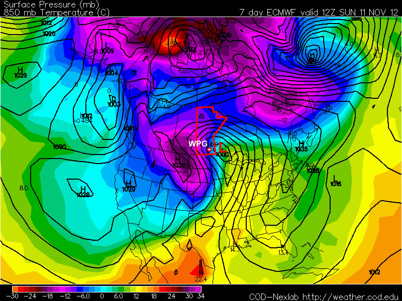
The ECMWF model is predicting that a major winter storm will impact Southern Manitoba next weekend

The ECMWF model is predicting that a major winter storm will impact Southern Manitoba next weekend

Monday’s weather will be fairly seasonal, with high temperatures just above zero. There may be some light rain during the afternoon and evening hours as a trough of low pressure swings through, though nothing particularly significant. Tuesday will see little change from Monday, with temperatures once again in the low single digits. Perhaps the biggest difference between these two days will be the wind direction, with the wind being north-westerly on Tuesday, as opposed to southerly on Monday. Wednesday will once again be a seasonal day, with temperatures around or slightly above zero.

The main attention this week will be focused on the potential for a major weather system next weekend. Weather models are currently showing a significant Colorado Low system impacting Southern Manitoba next weekend, with the potential for heavy snow and strong winds. At this point it is impossible to predict exactly how this system will affect us, other than to say it could cause significant disruptions. Just as it is impossible to know the exact impacts of this storm this far in the future, it is also not possible to know for sure if this storm will hit us at all. Based on the latest guidance, there does appear to be a reasonable chance of it impacting Southern Manitoba in some way, but we won’t be sure for a few more days. In the meantime, we’ve got some interesting weather to talk about!

Small Warm-Up

We’ll see warmer conditions for the beginning of this week. Temperatures may even climb above normal!

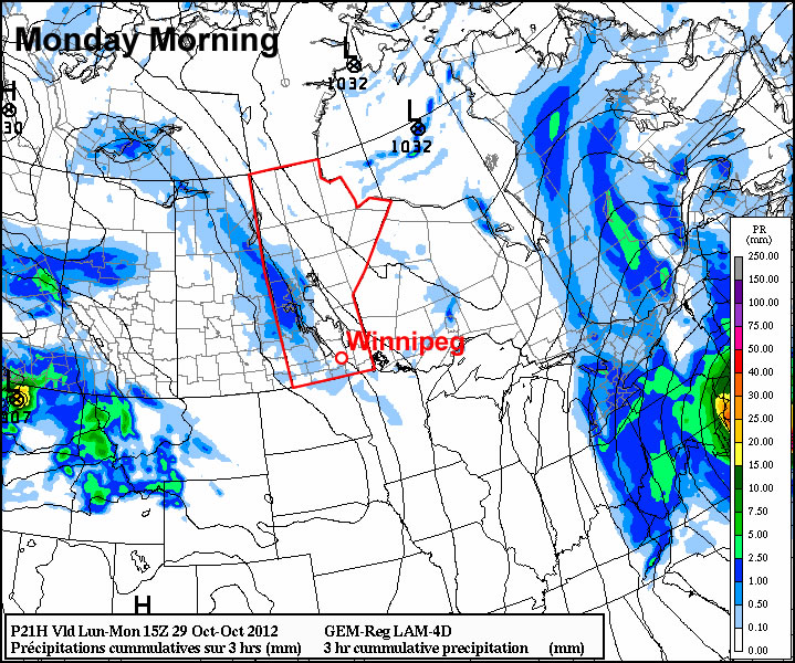
Shower activity on Monday

Light rain over parts of Manitoba on Monday

While Sandy hits the eastern coast of the United States hard during the early part of this week, the weather in Southern Manitoba will be very quiet. Temperatures on Monday will be in the mid to upper single digits in Southern Manitoba, which is near to slightly above the average daytime high of 5C. In terms of precipitation, a passing upper-level disturbance on Monday will generate cloud and some light showers in Southern and Central Manitoba. The most favoured area for shower activity is Western Manitoba, though other parts of Southern Manitoba stand a small chance of seeing a light rain shower. On Tuesday a passing trough of low pressure may once again generate a few showers, though they will be very light and scattered in nature. Tuesday’s high temperatures will be very similar to Monday’s, once again being in the mid to upper single digits.

Halloween Wednesday will be a chilly day, as cool north-westerly winds flow out of a surface ridge over Saskatchewan. Temperatures during the daytime will only be slightly above zero, but will drop near to or slightly below zero by the trick or treating hours. No precipitation is expected on Wednesday.

Conditions through late week will remain fairly seasonable, with daytime highs hovering near to or slightly below 5C. No major shifts in our weather are expected in the foreseeable future. In general, seasonable to slightly below seasonal values are expected over the next while.

Mainly Seasonal With A Chance of 30°C

We’ll see fairly typical weather for this time of year across Winnipeg and the Red River Valley with a big exception being tomorrow: with southerly winds and a big upper ridge moving across the region, there’s a good chance we’ll see temperatures in the upper 20’s, perhaps even breaking 30°C on Saturday afternoon.

500mb Wind Speed

500mb wind speed from the GEM-REG for midday today depicting the upper ridge that is moving into the province.

We’ll see plenty of sunshine today as the aforementioned upper ridge begins working it’s way into our region. Temperatures will be able to climb up much higher than yesterday, where a cool air mass combined with clouds limited our temperatures. We’ll see a high near 25°C today, although it will be a bit of a climb as we dig out of a rather chilly morning.

On Saturday, the upper ridge will move across the province, bringing with it 850mb temperatures in the 17-18°C range. Winds will be out of the south, not the southwest, so we won’t see any significant downslope effect to help our temperatures out. As a result, we’ll see widespread highs near 28°C with a few locales getting as high as 29 or 30°C by the late afternoon.

A powerful cold front will dive southwards through the Red River Valley on Saturday evening which will usher cool Arctic air in from the north. 850mb temperatures will plummet to nearly 0°C for Sunday which will hold our daytime high to the mid-teens, most likely below the seasonal normal high of 18°C, under cloudy skies.

Cooler air will continue to push southwards into the beginning of next week, with 850mb temperatures dropping below 0°C on Monday and remaining over the region for much of the week. This will likely result in daytime highs in the mid-teens and overnight lows in the low single-digits for much of the week under more cloud than sun and a chance of showers on and off through the week.