Elsewhere in Weather News: June 21st, 2014

South Dakota Wessington Springs Tornado – June 18th, 2014

Three members of A Weather Moment team headed out to South Dakota this past Wednesday to chase severe storms and try to catch a tornado. It turned out to be quite the event. Julien has written a summary of what how the chase unfolded.

We left Winnipeg bright and early at 7 am on Wednesday and headed south. Our plan for the day was to target the warm front/triple point in southeastern South Dakota. We reached Fargo by late morning. After getting our internet worked out and had lunch, we continued south to Sioux Falls, South Dakota to reassess things (by then it was mid/late afternoon). We decided to head west a bit to Mitchell first, then Plankinton, SD. It was oppressively humid with dewpoints in the low to mid 20’s and temperatures near 30°C. In fact, as I walked out of the car, my glasses were fogging up! These yielded MLCAPE values around 5,500J/kg resulting in an explosive environment for any storm that formed.

By then, storms to our northwest were strengthening rapidly and rotation became evident on radar imagery. A tornado was also reported by another storms chaser. We were concerned of the possibility that additional storms would fire off south of the existing ones and become dominant. As a result, we decided to wait a little longer. Nothing new was really forming due to a strong cap, so we decided to head west then north of Kimball, SD to view the existing storms. We were impressed! Towers were shooting up extremely rapidly and there was decent structure to the storm. Rotation could be seen in some parts of the storm.

Not too long later, we repositioned north of Plankinton, SD, which was eastward. As we got closer to the storm, two funnels poked out of the trees! It was evident that the one in the distance was a tornado. However, the second funnel was hard to say if it was touching down or not because it was not condensed all the way to the ground. However, it’s impressive seeing 2 funnels simultaneously!

One funnel and a tornado simultaneously, with the one on the left touching down. (Taken by Matt)

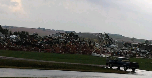
We followed the storm eastward and the dominant tornado was not giving up! Even though we were well in the distance far away from the tornado, we could clearly see its circulating winds moving rapidly which was quite impressive. Unfortunately, we did occasionally see debris being picked up. It took several minutes for the tornado to finally rope out and lift… before we witnessed it strengthening and enlarging again briefly. Then it dissipated and that was it for tornadoes for us for the day. After our chase was finished, we had heard that there was serious damage to the town of Wessington Springs, SD however no serious injuries had been reported thankfully.

Stovepipe tornado we observed. (Taken by Matt)

We slowly made our way east to Brookings, SD for the night at a hotel. We left back for Winnipeg Thursday morning before 11 am and reached Winnipeg by around 6 pm or so after stopping by at Longhorns restaurant for a well-deserved tornado steak dinner in Fargo. The next day NWS had done a damage survey of the tornado and rated it an EF-2 tornado, the strongest tornado we had ever witnessed. Overall, it was well worth the trip!

This trough not only produced tornadoes on Wednesday in South Dakota, but also on Monday and Tuesday in Nebraska, including the incredible supercell near Pilger, NE that produced two large wedge tornadoes simultaneously. The upcoming pattern definitely looks calmer with upper flow slacking up in the US Plains; possibly hinting that summer is right around the corner for the region.

Elsewhere in Weather News: October 5th, 2013

Quadruple threat in the US this Week

All kinds of extreme weather have been plaguing the United States this week; from tropical storms, tornadoes to blizzards to severe Santa Ana winds, they’ve just about seen it all. It was all happening yesterday due to a dynamic low pressure system centered in the Northern US Plains. High pressure building behind the low pressure system was responsible for the Santa Ana winds. The tropical storm, a completely separate system, has been targeting the gulf shores for a few days now.

The powerful fall low pressure system was drawing in brisk air from the north behind it which helped produce ideal conditions for blizzard conditions in the Black Hills. It was not unusual to see snowfall rates in excess of 5cm/h throughout the day on Friday in the region. The hardest hit area in regards to snow looked to be Lead, SD, which by Friday night had received 110cm (in less than 48 hours!), and another 20-30cm could fall before deformation zone moves off.

Lead, SD snow

Streetcam picture of the snow accumulated in Lead, SD. Keep in mind there was no snow on the ground less than 48 hours ago! (Source: Twitter: @TylerJRoney)

Deadwood, SD snow drifts

Incredible image of a large snow drift almost completely covering the front door in Deadwood, SD. (Source: Twitter: @ReadingReineke)

In the warm sector of the same system severe thunderstorms were spawned on Friday. A few supercells formed in the late afternoon near the triple point in northern Nebraska/extreme southern South Dakota. With extremely favourable conditions for tornadoes, storms quickly started rotating. The number of tornadoes is still unclear at this time but a violent, long tracked, wedge tornado which was reported to be over a mile wide, touched down. Per initial reports it appears as though Wayne, NE was the hardest hit on Friday by this tornado. Houses and factories were completely demolished and two dozen people were reported injured. A squall line also evolved further south into Kansas and Oklahoma where large hail and severe wind were the main threats.

Wayne, NE damage

Damage of a factory destroyed in Wayne, NE from the tornado that hit the town. (Source: Twitter: @action3news)

The Santa Ana winds have been a treat to California this week, too. These winds get funneled through the Mountains of Southern California, subsequently warm and dry as they descend in elevation. Gusts in excess of 110km/h have been tearing through Southern California bringing with them an extreme fire risk. This prompted the National Weather Service (NWS) to issue multiple red flag warnings for the area – these warnings are issued when conditions are ideal for wildfires and quick intensification. The NWS also added that these were the worst winds in five years.

As for the tropical storm (Karen) spinning in the Gulf of Mexico, it does not appear that it will become a significant hurricane. Strong wind shear has been affecting its development for the past few days. It will likely make landfall as a tropical storm with winds of tropical storm force, but possibly even weaker depending on how much the shear tears the storm apart. The location of the landfall looks to be on the south-east gulf shores of Louisiana. It doesn’t appear as though its effects will be too significant to the US – heavy rain will be the main threat with Karen. Otherwise, the tropics continue to remain unusually calm and no other developments elsewhere in the Atlantic basin are expected in the near future.