Staying Hot, Storms Possible

This week will start out right where last week left off – hot!

Monday's temperatures at 1pm

Temperatures at 1pm on Monday. The dark green colour represents temperatures between 30 and 35C.

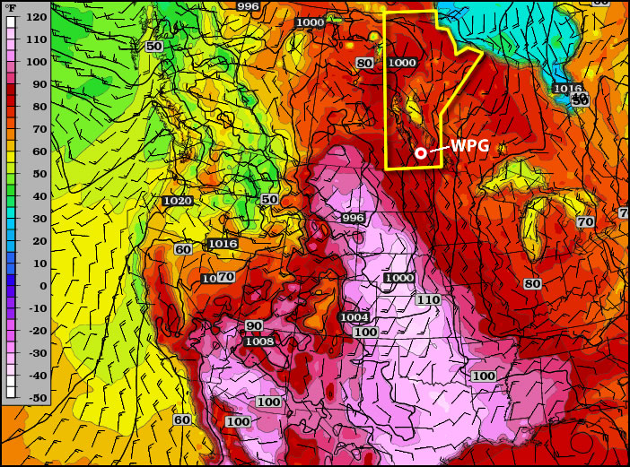
Today will be another hot and humid day in Southern Manitoba. High temperatures are expected to be in the upper twenties, or possibly thirty degrees, with thunderstorms possible both in the morning and later in the day. There will some cloud and possible rain or thunderstorms during the morning from a decaying thunderstorm complex. The speed at which this complex clears the region will determine how hot it will get. The progress of this complex will also determine if there is a second round of storms on Monday afternoon and evening. If it stays cloudy all day with temperatures remaining low then it is unlikely that there will be a second round of storms later in the day. Based on current model guidance it does appear that the clouds will clear out in the afternoon, but there remains some uncertainty with this.

Tuesday will be hot once again, but somewhat less humid than Monday. Temperatures will be up near 30C, but thunderstorms are not expected.

Wednesday will be yet another tricky forecast. A cold front is expected to swing through Manitoba at some point on Wednesday, but it is not entirely clear when that will happen. If the cold front goes through in the morning the day will be warm, but not humid, with highs in the mid to upper twenties. However, if the front only goes through in the evening it will be hot and humid with the risk of severe thunderstorms. The details of Wednesday should become more clear over the next day or two.

You’ll probably be surprised to hear that more hot weather is expected to start July (hint, I hope you’re NOT surprised). Models point to continued hot weather for at least the next 7-10 days as we roll smoothly in the heart of summer.

A quick note…Myself and Matt will be chasing south of the border today! You can keep tabs on our progress using the twitter feed by clicking through below.

new TWTR.Widget({
version: 2,
type: ‘list’,
rpp: 30,
interval: 30000,
title: ‘July 2nd, 2012’,
subject: ‘AWM Storm Chase’,
width: ‘auto’,
height: 500,
theme: {
shell: {
background: ‘#3c3c3c’,
color: ‘#eeeeee’
},
tweets: {
background: ‘#eeeeee’,
color: ‘#2c2c2c’,
links: ‘#489ce1’
}
},
features: {
scrollbar: true,
loop: false,
live: true,
behavior: ‘all’
}
}).render().setList(‘WeatherInThePeg’, ‘awm-team’).start();

The Heat Is On!

This week will feature warm to hot weather in Southern Manitoba, a trend which is expected to continue into the long weekend.

Temperatures will be hot over much of Central North America this week

Tuesday’s high temperatures. Reds indicate temperatures near 30C.

A ridge of high pressure will be in place over Manitoba on Monday and Tuesday of this week. This ridge will pump warm air into the province, allowing high temperatures to reach the high twenties and even low thirties. Monday will be quite nice, with temperatures in the high twenties over all of Southern Manitoba. Humidity levels on Monday will remain low, making the day rather comfortable. By Tuesday the humidity will increase somewhat, but will still remain reasonable even as temperatures climb to around thirty degrees (except in Western Manitoba where the air will be a bit more tropical). A cold front will slice through the province on Wednesday, knocking down humidity levels with a strong westerly wind. However, temperatures won’t drop off by much, with highs staying in the mid to upper twenties on Wednesday.

CAPE graphic. CAPE is a measure of how unstable the atmosphere is, in other words, how severe a storm could potentially become

CAPE values are expected to be moderate to extreme over the prairies early this week. CAPE is a measure of how unstable the atmosphere is, in other words, how severe a storm could potentially become

You may be wondering if this heat will generate thunderstorm activity as the cold front moves in on Wednesday. The short answer to that question is maybe, but I will elucidate. There will certainly be severe storms in Saskatchewan on Monday and Tuesday this week, but the threat in Manitoba is less clear. At this time it looks like our best chance for seeing storms will be on Tuesday night into Wednesday morning as storms that develop over Saskatchewan and North Dakota drift into Manitoba during the overnight period. Even though these storms will happen after dark they may still be severe as they will have warm and humid air to work with. There may also be the risk of thunderstorms during the day on Monday and Tuesday in portions of west-central Manitoba (i.e. Swan River, The Pas, etc). Since these regions aren’t our focus, I won’t go into much further detail than that. Nocturnal thunderstorms may drift into Western Manitoba on Monday night or Tuesday morning, but aren’t expected to impact the majority of Southern Manitoba.

After the cold front passes through on Wednesday there will be a couple of days where the heat “reloads” ahead of the long-weekend. In other words Thursday and Friday will be a bit cooler, although still warm, with temperatures more in the mid twenties. It is expected that hot weather will crank up again for the long-weekend, with present modelling suggesting that temperatures near thirty degrees will be possible on Saturday, Sunday, and Monday. It is too early to be certain in those predictions, but at this point the long-weekend is looking rather nice…if you like hot weather that is.