Occasionally Unsettled, Smokey as Seasonal Temperatures Return

An upper low over the northern Prairies will bring relief from the heat along with unsettled conditions, but smoke will continue to be an issue.

ECMWF 24-hour Precipitation Accumulation valid 06Z Wednesday June 4, 2025
Scattered showers are possible across much of southern Manitoba while far northern Manitoba sees accumulating precipitation. Little rain is expected where it is needed most.

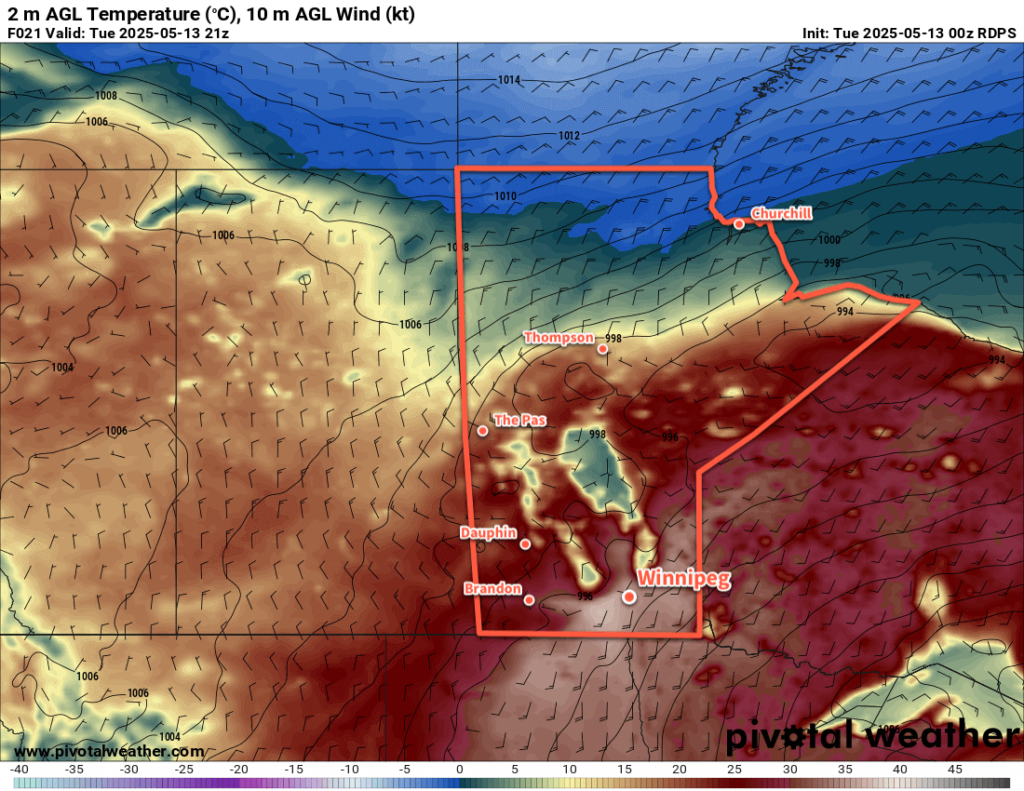
Over the past few days, the upper ridge over the Prairies has been replaced with an upper low anchored near the Hudson Bay coast. Its influence will linger over Manitoba for much of the week as it gradually trundles into Hudson Bay.

For Winnipeg, this means daytime highs will sit in the 20 to 25 °C range for much of the week with mixed skies developing most days. Overnight lows should sit within a few degrees either side of 10 °C.

There will be a few chances for showers or thunderstorms across the region over the coming days. The best chance for much of the region will be this afternoon. Scattered showers and thunderstorms will develop over central Manitoba midday then spread south through the afternoon. With up to 500 J/kg of MLCAPE (instability) and 20 to 30 knots of bulk shear (organization), many of these showers will be capable of developing into thunderstorms. No organized severe weather threat is expected from the activity this afternoon.

The showers will taper off through the evening and skies will clear.

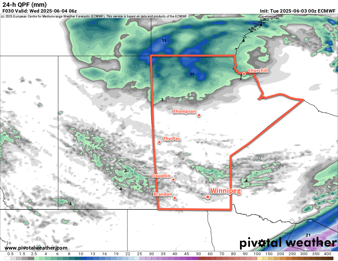
More showers or thunderstorms will be possible Tuesday, but they won’t likely be in Winnipeg. The best chance will be through the Interlake east towards the Ontario border with a slight chance of a few in southeast Manitoba.

On Thursday, a few showers or thunderstorms will be possible from central Saskatchewan southeast into Parkland Manitoba. Another area will develop in the afternoon through the northern United States; a few may track along the border regions but aren’t expected to push further north at this time.

All that said, it means that though there will be a chance of showers or thunderstorms almost every day ahead in southern Manitoba, today will be the only day they’re likely to happen in Winnipeg.

Air Quality an Ongoing Concern

Over the next few days, west to northwest winds will dominate; light winds at night will strengthen into the 20 to 30 km/h range during the day with gusts of 40 to 50 km/h. These winds will draw plumes of wildfire smoke into the region.

The simpler part of the smoke forecast is much of central Manitoba, the Parkland, Interlake, and areas east to the Ontario border will be smothered in smoke for much of the week. Expect very poor air quality through much of the week ahead.

For areas further south, plumes of smoke will either graze by or move through over the coming days. The first push of smoke will move into the region later today with a plume grazing Winnipeg and the northern Red River Valley on its way into the southeast corner of the province. The smoke will clear tonight, then another plume is forecast to slump into much of southern Manitoba on Wednesday morning, then gradually clear from west to east through the afternoon.

Smoke forecasts don’t extend past this point, but it looks like another plume of smoke may impact the Winnipeg area on Thursday. Keep in mind that smoke spread is difficult to forecast, and it’s likely that the details and timing may shift in the days ahead. Keep an eye out for air quality advisories from the MSC in the coming days.

Long Range Outlook

Warmer weather will push into the region to end the week, likely bringing daytime highs into the 25 to 30 °C range. Nocturnal showers or thunderstorms may be possible overnight Friday into Saturday, then widespread showers or thunderstorms will be possible later Saturday into Sunday as a cold front moves through the region.

It’s likely that smoke conditions will improve with the push of warmer air, but more smoke is likely behind the cold front on Sunday.

One of the main things to note is that for the foreseeable future, any northwest, north, or east-northeast wind may bring wildfire smoke into the region.

Today’s seasonal daytime high in Winnipeg is 22 °C while the seasonal overnight low is 9 °C.

Scorching Heat to Give Way to Unsettled and Much Cooler Weather

The scorching heat and dangerous fire conditions will persist in Winnipeg and the Red River Valley for another day before the heat shifts east and showers and thunderstorms move into the region.

RDPS 2m Temperature Forecast valid 21Z Tuesday May 13, 2025
Tuesday will bring another day of scorching heat and dangerous fire conditions in southern Manitoba.

Winnipeg will be off to a hot start today with temperatures in the low 20s that quickly climb to 30 °C by lunch. Southerly winds will pick back up to 40 gusting 60 km/h as temperatures continue to climb to a high in the mid-30s. Relative humidity will again drop below 20% today, which coupled with the heat and moderate winds will pose another risky fire weather day for the region. There will be a slight chance of an isolated evening shower or thunderstorm, but nothing substantial is expected for the region. Temperatures will head to a low in the mid-teens tonight with winds shifting to the north and easing.

On Wednesday, an upper low will shift from Idaho into southern Saskatchewan. As it pushes into the region, it will support a broad area of showers and thunderstorms that move from southeast Saskatchewan into western Manitoba and across the Interlake region. This broad area of cloud and rain showers will intensify the temperature change across a warm front draped southwest-northeast across southern Manitoba. Over a short distance, temperatures will change from around 30 °C on the warm side of the front to the upper teens on the cold side of the front. Right now, Winnipeg is forecast to sit barely on the cold side of the front with a high in the mid-20s, but small changes in the position of that front may change the daytime high by 5 °C or more.

Showers and thunderstorms will blossom across Manitoba on Wednesday night, but much of the activity looks to move through west and north of the Red River Valley. Temperatures in Winnipeg should dip down into the mid-teens on Wednesday night with cloud cover beginning to move into the area.

On Thursday, the unsettled weather will shift east into the Red River Valley as a pair of shortwaves lift north out of the Dakotas towards southern Manitoba. Temperatures will peak in the low 20s as more cloud and scattered showers and/or thunderstorms push through the region. with moderate northwest winds up to 40 gusting 60 km/h developing through the day.

On Thursday night, unsettled showery conditions will likely transition to periods of rain as temperatures continue to cool and a much broader, more organized low pressure system develops. Temperatures will dip down into the mid-single digits overnight with moderate northwesterlies continuing.

Long Range Outlook

Heading into Friday, periods of rain will continue through the day as more cold air pushes into the region. Temperatures will hold steady or even fall through the day, potentially dropping as low as +1 or +2 °C. Heading into Friday night, temperatures may drop to freezing, and precipitation over the region could turn into a wintery mix of rain and/or snow with a risk of freezing rain. Those northwest winds will continue through the night.

Heading into the weekend, the precipitation looks to gradually taper off on Saturday with a high in the low single digits and easing winds. Temperatures may dip below freezing on Saturday night. Cloudy skies will likely stick around into Sunday with a warmer high in the 5 to 10 °C range.

Temperatures will slowly trend towards seasonal values this week, but another disturbance mid-week may bring more rain to the region and keep temperatures seasonably cool through the week.

Today’s seasonal daytime high in Winnipeg is 19 °C while the seasonal overnight low is 5 °C.

Warm Late-Summer Weather Continues

A persistent southerly flow over southern Manitoba will keep the seasonably warm and humid conditions in place for a for a few more days.

RDPS 2m Temperature Forecast valid 21Z Wednesday September 18, 2024
A stalled low over eastern Montana will continue to pump warmer air northwards into southern Manitoba this week.

A quick note to start: the lack of forecasts last week was due to the fact that I’m dealing with a long-lasting bout of COVID–19 that’s sidelined me for a while now. I’m on a [gradual] up and up now, with symptoms finally receding after testing positive on rapid tests for a whopping 11 days in a row. Not a fun time, looking forward to getting back at life.

Daytime highs in the mid-20s will continue into mid-week for the Winnipeg area as a persistent low pressure complex to the west supports a southerly flow across the region. Daytime highs for Tuesday and Wednesday will likely sit around 25 °C; it could be a touch cooler if a bit of a stronger cold pool is left behind from overnight convection, or a tad warmer if we clear out early and a stronger southerly flow can develop earlier in the day.

The humidity will also be notable for mid-September, with dew point values in the mid- to upper-teens, potentially reaching around 20 °C on Wednesday. This is more humid that the region often sees at this time of year, but the lower daytime highs in the 20s should keep the worst of the heat effects at bay. In the sun, the heat and humidity could combine to feel like it’s in the low 30s rather than mid-20s.

RDPS 2m Dew Point Temperature Forecast valid 21Z Wednesday September 18, 2024
In addition to the seasonably mild temperatures, it will continue to be humid across southern Manitoba.

Overnight lows both tonight and tomorrow night will sit in the mid-teens.

Weather-wise, today should bring clearing skies as the disturbance that brought rain and thunderstorms to the region yesterday pushes off to the east. A few clouds will begin to build back in tonight, leading to mixed skies on Wednesday as a cold front approaches the region from the west.

A few showers are possible on Wednesday; it looks like they should be weak, though the slow-moving nature of the cold front and broad forcing could result in a narrow band of slow-moving showers that could produce some locally higher amounts in the 15 to 25 mm range. I’m doubtful Wednesday will be a “wet” day, more likely a cloudier one with the chance of passing showers.

The cloudiness and chance of showers will continue into Wednesday night.

Unsettled End to the Work Week

The low that’s been sitting to the west all week will finally get moving on Thursday, moving into southwest Manitoba on Thursday and sliding into northern Manitoba on Friday.

This will bring a notable change in the weather to southern Manitoba. To start, both Thursday and Friday could bring wet conditions to the Red River Valley. On Thursday, showers and thunderstorms will begin possible through much of south-central and southeast Manitoba as the forcing along the cold front picks up with the advance of the low. This activity will likely continue into the night as it pushes northeast.

Winds will finally shift on Thursday from the persistent southerly at 20 to 30 gusting 50 km/h seen much of this week to westerly winds of 15 to 30 km/h.

On Friday, showers in the instability on the back-side of this system may clip through southern Manitoba as cooler air moves into the region. Daytime highs will cool into the low 20s by the end of the work week.

Long Range Outlook

Heading into the weekend, more settled conditions will develop over the region as near-seasonal temperatures return. Winnipeg will see partly cloudy conditions over the weekend with daytime highs in the upper teens and overnight lows near the 10 °C mark.

This trend looks to continue into the start of next week.

Today’s seasonal daytime high in Winnipeg is 18 °C while the seasonal overnight low is 6 °C.

Seasonably Cool Temperatures Ahead, Chance of Rain for Thursday

In a stark contrast to the past weekend, a ridge of high pressure will keep temperatures seasonably cool much of this week. A passing low pressure system will bring milder temperatures on Wednesday followed by a chance of rain on Thursday.

RDPS 2m Temperature Forecast valid 21Z Tuesday August 27, 2024
Seasonably cool temperatures will sit over southern Manitoba today while warmer weather builds back into the western Prairies.

An Arctic high trundling east across northern Manitoba will keep temperatures cool and the humidity dry today. A disturbance rolling across North Dakota towards Lake of the Woods will bring cloudy skies into the region later this morning. Combined with a light northeast wind, daytime highs will be cool at around 20 °C in the Red River Valley.

Skies will clear this evening as the disturbance heads off into Ontario. The Arctic high will trundle towards James Bay, shifting the light winds in the Red River Valley southerly. Temperatures will dip down to a low near 10 °C.

On Wednesday, the next weather system to impact the region will begin taking shape. A vigorous upper-level disturbance will move from the British Columbia interior into today to southern Alberta by Wednesday. As this tracks east, it will pump much warmer air back into Saskatchewan as a low pressure system develops over the central Prairies. By Wednesday morning, a low will sit over central Saskatchewan with a warm front that drops southeast across southern Manitoba and a cold front southwards towards the Montana/North Dakota border.

This system will bring southerly winds to Winnipeg on Wednesday up to around 30 gusting 50 km/h. Temperatures will be warmer with highs in the mid-20s under mainly sunny skies. In the evening, a low-level jet — a corridor of fast-moving air about 1.5 to 3 km above the ground —will develop with wind speeds around 60 km/h (30–35 knots). These will help develop and sustain a band of showers and thunderstorms through the night that extend from North Dakota northwest to central Saskatchewan. For areas in southern Manitoba, there will be a low risk of a severe thunderstorm on Wednesday night with large hail and wind gusts the main hazards.

24hr. Precipitation Accumulation Forecast valid 00Z Friday August 30, 2024
One model’s forecast for daily rain accumulations on Thursday; while likely too widespread, it shows that showers are possible across much of southern Manitoba on Thursday.

Temperatures will dip to a low in the mid- to upper-teens on Wednesday night with moderate southeast winds continuing.

The band of [thunder]showers will reach Winnipeg either late overnight or early Thursday morning, then sunny breaks will develop after they pass as winds shift westerly. Temperatures will climb back up to the low 20s with mixed skies and a chance of more showers in the afternoon.

Temperatures will head to a low in the mid-teens on Thursday night with partly cloudy skies and west-northwest winds of 20 to 30 km/h.

Long Range Outlook

Settled conditions will redevelop for the end of the week and into the weekend as the mid-week disturbance heads off. A ridge of high pressure will build in from the west and bring settling conditions and sunnier skies.

Daytime highs should sit in the 20 to 25 °C range through the weekend with overnight lows slumping from the mid-teens to around 10 °C.

It’s a pretty pleasant forecast, and will be a nice recovery from the intense heat and humidity the region experienced over the weekend. I hope families with kids can get out there and enjoy the final days of summer before school kicks off again!

Today’s seasonal daytime high in Winnipeg is 24 °C while the seasonal overnight low is 10 °C.