I know this isn’t directly related to Southern Manitoba, but the events over the past few days have been so significant I can’t pass up the opportunity to talk about them. On Sunday, a massive tornado that was recently upgraded to the category EF5 tore through Joplin, MO, killing 125 people and injuring upwards of 750 people. Over 1500 have been reported missing, however this number is likely inflated as they are preliminary reports mostly from family and some “missing” peoples were simply out of town. The tornado damaged or destroyed over 800 structures and caused in excess of $1 billion.

The swath of damage caused by the tornado is easily visible from the sky.
Many thought that this disaster would not be seen for a long time, however mother nature had a completely different opinion yesterday and many, though not all, Kansas, Oklahoma and Texas residents dodged quite a few bullets yesterday.
Around 3PM yesterday storms started to develop along a dryline pushing eastwards out of Colorado and New Mexico into the Central Plains. This feature was extremely strong, with some sites going from 29/23 (temperature / dewpoint) to 38/-12 in a matter of a couple hours. This would be equivalent to going from one of the muggier, more humid days in Southern Manitoba to the Nevada desert over lunchtime. Normally, this would be a significant enough feature in itself, but there was also a powerful shortwave moving into the area with an associated 90 knot jet streak about 5km off the ground. This was, for all intents and purposes, a perfect setup for severe storms.
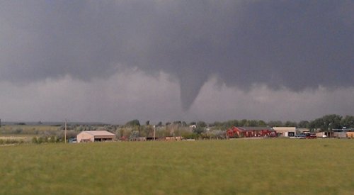
The Storm Prediction Center (SPC) issued a high risk for for the Central Plains yesterday morning, and issued a PDS statement (Particularly Dangerous Situation) near lunchtime when they issued the tornado watch. By mid-afternoon storms were in full swing. The northern end of the town of El Reno, OK was hit by a tornado, which killed two people, demolished several houses, and was responsible for a gas explosion. This picture is a great indicator of how powerful this twister was:

A car pinned against trees that have been significantly de-barked in El Reno, OK.
There was even a weather station on the north end of town that experienced a significant portion of the power of this tornado:

Readings from a weather station in North El Reno. At the time of the tornado, the station measured a peak wind of 151 m.p.h and a drop in pressure to almost 940mb.
El Reno was not the only town to suffer, though. The town of Piedmont, OK was hit hard:

(Photo: Reuters / Bill Waugh)
Dozens of homes and businesses were lost in Piedmont. Two children were killed, a third missing, and their mother is in critical condition. This repeats itself, unfortunately. Oklahoma City was put under a tornado warning only for the tornado to dissipate shortly before entering the city. Instead, debris rained down on the city, enough to make the I40 impassable in at least one spot. The Norman, OK weather center, home of the SPC was evacuated. Baseball-sized hail fell at the baseball stadium in Arlington, TX as well as through much of Fort Worth. More details have yet to emerge, but it sounds as if the town of Denning, AR may have been wiped off the map by a tornado.
It was a tragic day through much of the Central Plains. The current death toll of 15 is likely to rise as the damage is assessed today and people start to examine and clean up. At least 4 significant tornadoes occurred yesterday, and several were on the ground through the night. It was another unfortunate and deadly day in a country that is quickly approaching its deadliest year ever with respect to tornadoes. And it isn’t over yet. The SPC has issued another high risk outlook for portions of Arkansas, Tennessee, Indiana, Kentucky, Illinois, and Missouri, with a moderate risk encompassing a much greater area:

It’s an extremely unfortunate year for tornadoes, and at this point it’s hard to imagine that they won’t surpass their deadliest year ever for tornadoes this summer. If there’s any good that might come out of this, it only emphasizes the importance of having a properly funded forecasting service that is working around the clock to ensure that people and property can be protected as much and realistically as possible. Good thing those budget cuts to the NWS didn’t go through…
The last thing I wanted to mention, perhaps my whole reason for writing this, is that I know many people who think that these sorts of things “don’t happen in Canada.” I’m here to say that they do. More often than one might think. Tornado alley, a colloquialism used to refer most frequently to the stretch from Oklahoma to South Dakota, actually extends much further than most people think it does. While tornadoes may be most frequent in those states, it slowly shifts north as summer goes on. The Dakotas and Minnesota are hotspots for tornadoes. By mid-to-late summer, tornado alley extends through Southern Manitoba and arcs westwards across Saskatchewan and into Alberta. One need not look far to see extremely significant tornadoes in Canada’s history:
- Reeces Corners Tornado (1983); millions of dollars in damages.
- Southwest Ontario Tornado Outbreak of 1984; 6 confirmed tornadoes, 30 people injured.
- The “Barrie” Tornado Outbreak of 1985; 13 touchdowns including a F4 tornado in Barrie, ON. 12 killed, 100 injured. Over 100 buildings destroyed at a cost of over $100 million. Complete destruction of 300 houses.
- Mississauga Tornado (July 7, 1985); Injures 10, $400,000 in damages.
- Saskatoon Tornado (June 1, 1985); 3 weak tornadoes touched down in Saskatoon. Roofs and windows damaged.
- “Black Friday” Tornado in Edmonton, AB (July 31, 1987); a strong F4 tornado (possibly F5) hit eastern sections of Edmonton. 27 people died and 253 were injured. One of Canada’s strongest tornadoes.
- Medicine Hat, AB Tornado (1988); Tornado caused estimated $50 million in damages.
- Saskatchewan Outbreak of 1989 (June 19, 1989); 8 tornadoes touch down over central Saskatchewan.
- Edmonton Tornado (July 27, 1989); Weak tornado in the west end of Edmonton. 2 people injured. Buildings damaged, trees and power lines uprooted.
- Mont-Saint-Hilaire tornado (November 16, 1989); An F2 tornado caused $2 million in damage in the community east of Montreal.
- Sarnia, ON (March 27, 1991); Early season tornado causes an estimated $25 million in damages.
- Southern Manitoba (June 24, 1992); 5 confirmed tornadoes as well as hail up to the size of tennis balls.
- Saint-Charles, QC (July 9, 1994); 1 person was killed when a F2 tornado tore through the town. 3 others injured and about 12 homes were damaged.
- Aylmer, QC Tornado (August 4, 1994); A F3 tornado injures 15 people in Aylmer, QC. Tornado path was 8km long and caused major damage to a downtown residential subdivision.
- Turtle Mountain, MB (August 27, 1994); An F4 tornado hits rural farmland with devastation evident at Mayfair Hutterite Colony. Well over $1 million in damages.
- Southern Ontario Tornadoes of 1996 (April 20, 1996); Two F3 tornadoes touch down in Grey County, Wellington County and Dufferein County. Significant property damage, 9 injuries.
- Saskatchewan (July 4, 1996); 9 tornadoes touch down in the Saskatoon, Maymont and Osler areas in Saskatchewan. An F3 was measured in the Maymont area. Homes and property were damaged in Osler.
- Hull, QC of 1999 (May 8, 1999); A tornado over Hull, QC caused $2 million in damages.
- Saskatoon Tornadoes of 1999 (May 18, 1999); 3 tornadoes touch down close to the western limits of Saskatoon, SK.
- Pine Lake, AB Tornado (July 14, 2000); An F3 tornado rips through the Pine Lake campground. 12 people killed.
- Guelph, ON Tornado (July 17, 2000); An F2 tornado struck the city of Guelph, ON causing around $2 million in damages.
- Wabamun, AB (August 13, 2003); A tornado touched down on a golf course and lake resort west of Edmonton, AB causing some injuries.
- May 2004 Tornado Outbreak (May 22, 2004); one strong F2 struck near Mitchell, ON and an F3 in nearby Gad’s Hill. Extensive property and infrastructure damage.
- Nipawin (May 23, 2005); A tornado touches down in and around Nipawin, SK.
- Southern Ontario Tornado Outbreak of 2005 (2005); Widespread damage path from Stratford, ON to Peterborough, ON and along Georgian Bay near Collingwood. Damages exceeded $500 million.
- Ontario Outbreak of 2006 (August 2, 2006); 14 confirmed tornadoes rip across southern ontario.
- Gull Lake Tornado (August 5, 2006); One woman is killed at the Gull Lake campground north of Winnipeg, MB.
- Eastern Prairie Outbreak of 2007 (June 22-23, 2007); At least 8 tornadoes across southeast SK and southern MB. The first confirmed F5 tornado in Canada occured at Elie, MB, just west of Winnipeg. It destroyed 4 homes and heavily damaged a flour mill. The tornado itself was described as “as bad as they get here in Canada.” A F3 wedge tornado also touched down near Pipestone, MB and Baldur, MB.
- Southern Manitoba (May 25, 2008); at least two tornadoes touch down in Southern MB. One reported near Altona, MB.
- Niverville Tornado (May 31, 2008); a tornado touches down in Niverville, MB.
- Southern Manitoba June Tornado Outbreak (June 27, 2008); 5 tornadoes touch down in Manitoba near Gladstone, Neepawa, Arden, Westbourne and MacGregor.
- Winnipeg Tornado (June 1, 2009); Unconfirmed tornado reported in Winnipeg near the McPhillips Athletic. Trees toppled on houses and a semi-trailer flipped over on Portage Ave and the Perimeter Highway.
- Southern Ontario Outbreak of 2009 (August 20, 2009); 18 confirmed tornadoes, the largest outbreak in Canadian history. They were:
– F2 tornado from Durham to Markdale; 1 death, many serious injuries.
– F2 tornado in Carksburg
– F2 tornado in Vaughan; 3.5 km path through the Woodbridge neighborhood
– F2 tornado in Vaughan; 2.7 km path through the Maple neighborhood. This and the previous tornado resulted in hundreds of homes being damaged.
– F1 tornado in Newmarket
– F1 tornado in Milton
– F0 tornado in Moonstone
– F1 tornado in Ril Lake
– F0 tornado in Dollars Lake
– F1 tornado in Gravenhurst
– F1 tornado from New Lowel to Edenvale; 12.6 km path
– F1 tornado in Haliburton
– F1 tornado in Haliburton Forest
– F0 tornado in Redstone Lake
– F1 tornado in Arnstein
– F1 tornado in Carlow/Mayo
– F1 tornado in Rice Lake
– F0 tornado in Orono
- Leamington, ON (June 6, 2010); F2 tornado went from Harrow through Kingsville and Leamington, ON. No deaths or injuries, but significant damage.
This is by no means a comprehensive list. Most of this information was gathered from here and I suggest you visit if you want more comprehensive information. This is to show that tornadoes are quite a common occurrence in Canada and it is important that people are aware of the danger they pose. Ensure you have a plan for your household on what course of action to take should your life or property be threatened by a tornado. As the summer heats up in the Prairies, so does the risk that the unfortunate news coming out of the states could be repeated here.