Elsewhere in Weather News: October 12th, 2012

Tropical Storm Hits Bangladesh

A surprisingly strong tropical storm impacted southern Bangladesh on Wednesday and Thursday of this week. According to the India Meteorological Department the storm was a depression, which would give it maximum sustained wind speeds of 52km/h. Forecasters did not believe it would have a significant impact when it hit land, but in its aftermath there have been at least 26 deaths with many people still missing.

Tropical Storm damage in Bhola

Some of the destruction in Bhola is seen on Thursday. The death toll is expected to rise further (AFP/File, Str)

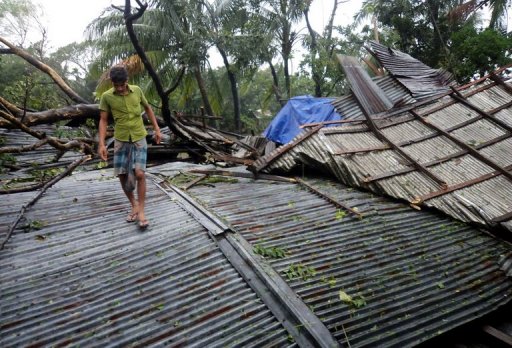
Strong winds from the tropical storm damaged houses and uprooted trees in coastal portions of Bangladesh. Crops were also severely damaged in the storm and some fisherman are feared lost at sea. Many fisherman suggested that poor forecasting downplayed the storm, which didn’t make it clear that they should stay on land.

Bangladesh is a relatively small, but densely populated country (estimated population is greater than 160,000,000) that is located in the delta of the Ganges river. The country’s low-lying coastal location makes it particularly vulnerable to natural disasters, including floods, tropical cyclones, and severe thunderstorms.

Sources:
http://www.ndtv.com/article/world/bangladesh-storm-toll-rises-to-26-scores-missing-278938
http://www.cnn.com/2012/10/11/world/asia/bangladesh-tropical-storm/index.html

Elsewhere in Weather News: September 7th, 2012

Tropical Storm Leslie a Threat to Canada

With the hurricane season nearing its peak in the Atlantic, more tropical systems have spun up this past week. The first system which is not much of a concern (unless you are boating in the middle of the Atlantic) is Michael. Michael, once a category three hurricane, the strongest seen this year, has been spinning in the middle of the North Atlantic for a while now and is not expected to make a landfall.

Leslie

Leslie still not organized very efficiently with a broad circulation on IR satellite as of Friday evening. (Source: Wunderground/NASA)

The second storm; Leslie, however, is spinning west of Michael and has a small chance at making a landfall somewhere on the south-eastern coast of Newfoundland, Canada. Bermuda is already experiencing high surf and there’s a good chance they’ll experience tropical storm force winds this Sunday since Leslie is such a large storm. By that time, Leslie will likely be upgraded to hurricane status of category one. It will slowly start moving north as the trough moving in from Eastern Canada approaches the storm. Though, with that said, Leslie still stands a slim chance at making landfall on Canadian soil and making a significant impact on the province. Since this possibility is still quite a ways away – five to six days – weather models are having trouble deciphering Leslie’s exact future track.

Leslie tracks

Model consensus appears to be leaning towards no landfall and more of a rain event for Newfoundland. (Source: SFWMD)

Even though Leslie might come close to Newfoundland within the next week or so, it appears the worst part of the storm will be well off to the east of the island as the top right quadrant of the storm where the strongest winds are located is not expected to affect land. The last time Newfoundland got struck by a tropical disturbance was back in October of last year where tropical storm Ophelia struck, dumping heavy rains on the Avalon Peninsula of Newfoundland. The most memorable hurricane to affect Newfoundland in recent memory had to have been Hurricane Igor, in 2008. This hurricane caused severe flooding to the eastern half of Newfoundland where in St. Lawrence, NFLD, 238mm fell. This was the most damaging hurricane to have ever hit Newfoundland in recent history.

Updates on Leslie will be forthcoming as it nears Canada!

Elsewhere in Weather News: August 25th, 2012

Isaac Threatens Southern States

This past week a tropical disturbance in the central Atlantic, east of the Caribbean, has strengthened into a tropical storm – Isaac. As of Friday night, Isaac had sustained winds of 112km/h, a central pressure of 990mb and was eyeing (no pun intended) Haiti. It is especially worrisome that Isaac, a strong tropical storm, is moving towards one of the most impoverished countries in the world, where nearly 400,000 people are still living in tents after the major earthquake back in 2010.

Isaac

Isaac on infrared satellite with centre of circulation identified by arrow. Purple, red represents very cold cloud tops. (Source: WSI)

Isaac will make landfall as a strong tropical storm as it crosses Haiti and then heads toward Cuba. It might have trouble sustaining its strength due to the mountainous terrain of the islands but as it emerges into the Gulf of Mexico, Isaac should organize itself quickly as it takes aim at the Gulf States such as Florida, Alabama, Mississippi and Louisiana. It is expected that Isaac will make landfall on American soil, somewhere on the western part of the Florida Panhandle on Tuesday afternoon. By that time Isaac will have intensified enough to be of hurricane strength, most likely category one. Residents of the Gulf States will have to monitor conditions closely to secure items outside and be ready to evacuate; storm surge along the coast and flooding because of the heavy rains is likely to occur. It will not be uncommon to see rainfall amounts of 100-200mm in the hardest hit areas in the Caribbean and US, however, the more rugged terrain of the islands on the Caribbean could have more devastating effects; landslides and flash flooding.

Isaac track

Isaac’s projected track. (Source: News 13)

In other news around the world, Taiwan has been hit with yet another storm – typhoon Tembin that had sustained winds of 155km/h but struck a less populated area of the country, leaving the large cities like Taipei with only minor flooding and wind damage.