Erika: Yet Another Tropical Disturbance in the Atlantic

Yet another tropical disturbance has developed over the Atlantic this week thanks to another mid-level wave traversing off the coast of Africa westwards over the Atlantic. It’s currently impacting the Dominican Republic and is forecast to head west-northwest towards the southeastern United States.

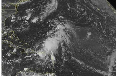
[map type=”terrain” autofit=”1″ disable_scrollwheel=”1″] [pin]Dominica[/pin] [pin]Dominican Republic[/pin] [/map]

Erika, which formed near the Cape Verde Islands, was centered near the southwest corner of the Dominican Republic as of Friday night bearing sustained winds of 75km/h and a rather unimpressive pressure of 1000mb. The tropical disturbance has struggled mightily at getting even somewhat organized over ocean waters; dry air and strong shear were both contributing factors to this. Erika is expected to continue experiencing problems organizing in the near future due to the strong wind shear in place, as well as a new concern – the rugged islands of Hispaniola.

IR satellite image of Erika on Friday night. Erika looks rather disorganized due to relatively strong shear present, but could still bring heavy rainfall to some Caribbean Islands. (Source: NHC)

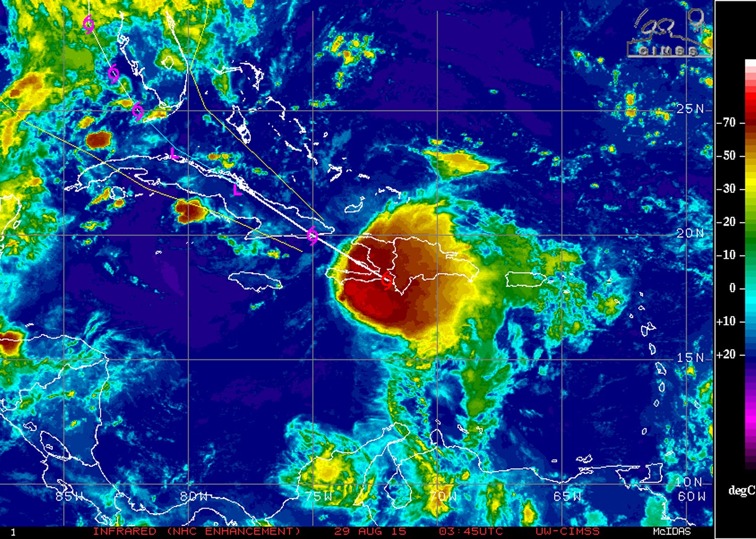
The heavy rains that accompany this tropical disturbance are not to be underestimated, however. Heavy rainfall in the order of 100mm to 150mm, as high as 250mm locally, is expected to fall across both the Dominican Republic and its neighbouring country, Haiti. There have already been 20 confirmed deaths associated with Erika from the island of Dominica (located in the Lesser Antilles), and three dozen more residents are still missing. In consequence, this tropical storm has been the deadliest natural disaster for the country since 1979.

The future of Erika remains uncertain at this point. Most models show Erika as weakening over the Caribbean islands (due to the shear/terrain problems discussed), then emerging over waters off of the western coast of Florida as a weak tropical storm. Overall, it’s unlikely that Erika will become anything more than a tropical storm that is just a rain-maker for southeast US.

In other news, it had been the year of the hurricane in the Eastern Pacific near the Hawaiian Islands. Several hurricanes have brushed by Hawaii already this year – an unusual occurrence. Yet another is on its way in the coming week. Hurricane Ignacio (category one) is expected to pass close to Hawaii. What remains to be seen is how close – Hawaii can at least expect high surf and heavy rainfall from the outer bands of Ignacio on Monday, but there is still some uncertainty on strength of the winds which depends on how close Ignacio comes. Another hurricane in the Eastern Pacific is churning; Jimena, is a high-end category four but is not expected to have any impact to land in the near future.

Elsewhere in Weather News: August 2nd, 2014

Weak Storm Forms in the Atlantic; Typhoon in Pacific

The second named storm of the Atlantic hurricane season spun up this past week and is still churning in the Caribbean. Tropical storm Bertha had sustained winds of around 80km/h as of Friday evening but had lots of dry air to its south and was not very well organized. By this evening it is expected continue its northwest track and pass between Puerto Rico and the Dominican Republic, bringing with it heavy rains as its primary threat. As much as 250mm of rain can be expected in the area which is a cause for concern in the mountainous regions. However, Puerto Rico has been experiencing drought for the past few months; the rain in the forecast is actually a welcome sight. On Sunday Bertha will have more of a northward track, curving up the Gulf Coast and likely dying off to the west of Bermuda due to cooler sea surface temperatures. None of the weather models show Bertha strengthening into a major hurricane and the US mainland is not expected to be impacted by this storm.

A large, more dangerous tropical disturbance has formed in the western Pacific this week and is already of category three status with sustained winds of 185km/h. Halong has a well-defined eye and eyewall in place, the only thing currently interfering with its development is some dry air to its north. The typhoon is currently located well east of the Philippines and is expected to be of no threat to the country as it will quickly curve Poleward this weekend. It, however, could pose a significant threat to Japan and China next week as it moves into the East China Sea as a strong typhoon. The islands of Okinawa could be in for a strong storm, as depicted by some models, but it is really too early to say for sure.

Typhoon Halong could become a super typhoon if it continues to strengthen at the rate it has been going. IR image taken Friday night.(Source: CIMSS)

Elsewhere in Weather News: September 7th, 2013

Tropical Storm Gabrielle Drenches Parts of Caribbean

The seventh storm of the Atlantic hurricane season spun up this past week, though did not affect the continental United States. The tropical storm, Gabrielle, did not reach hurricane status due to unfavorable conditions for storm development, including shear levels being on the high side. Shortly after it made landfall on Thursday it had been downgraded to tropical depression status. Drenching rains still fell across Puerto Rico, Dominican Republic and the US Virgin Islands thanks to Gabrielle’s southerly flow bringing in copious amounts of moisture (PWAT values approaching 75mm) from the Caribbean Sea.

Gabrielle

Gabrielle shortly after it got downgraded to a tropical depression on Thursday early afternoon. (Source: WUnderground)

As of Friday morning the highest rainfall amounts came out of St. Thomas where 175mm had already fallen. In general anywhere between 100mm to 250mm will have fallen across the region after Gabrielle has moved off to the north in the middle of the Atlantic Ocean. Friday evening the storm had been almost completely torn apart north of Puerto Rico and wasn’t a threat to land anymore. No deaths or injuries have been reported with the storm.

Surprisingly there has not been one hurricane in the Atlantic so far this year and if there continues to be a lack of hurricanes until September 16th, a record for the latest start to a hurricane season (since records began) would be achieved. However, longer range models such as the GFS have been showing tropical development in the Caribbean as well as another wave coming off Africa’s west coast in the near future which will be something to keep an eye on.

Elsewhere in Weather News: August 17th, 2013

Utor Update

Since last’s week update on typhoon Utor, much has happened. Utor first made landfall in the Philippines; it wreaked havoc as a high-end category 2 typhoon bringing sustained winds clocked at 170km/h with gusts exceeding 200km/h – making it the strongest storm this year in the area. Following that, it continued on through the South China Sea and made a second landfall as a strong tropical storm on the south shores of China.

Unfortunately, quite a bit of destruction was associated with this typhoon, especially in the Philippines region. Flash floods washed away homes in the central part of the Philippines and landslides were more of a problem in the northern region; due to a more mountainous terrain. Seven people have been casualties of the storm in the Philippines and 42,000 have been reported homeless because of Utor. In addition to causing grief to the Philippines, Hong Kong and part of China (mostly Guangdong province) had to take their precautions to keep residents safe. Stock markets as well as businesses were closed and 118 flights needed to be cancelled. One cargo ship also had to be abandoned at sea as it flipped because strong winds from Utor. All of the 21 crewmembers were airlifted to safety.

Utor damage

Ship flipped 90 degrees sideways because of strong winds of Utor. (Source: The Nation/AFP)

Disturbances in the Atlantic

Two areas of interest have formed in the Atlantic Ocean, one near the Cape Verde Islands and another off the Yucatan Peninsula. The first one near the Cape Verde Islands, named Erin, is of tropical storm force and is drifting west. It will be interesting to see how it interacts with dry air the next couple of days. There is a possibility it might not survive not only because of the dry air but also because of “cooler” sea surface temperatures near 26°C. The second area, a broad area of thunderstorms, is not of tropical storm force and may never become a tropical storm. There is much uncertainty where this system will make landfall and how strong it will get. Models show anywhere from Louisiana to Brownsville, Texas. Wherever it will make landfall it will be a big rainmaker though, bringing in very moist air from the Gulf of Mexico; PWAT values over two inches.

Erin

IR Satellite image of Erin as of Friday night. Quite a bit of dry air on the south part of the storm. (Source: CIMSS)