Elsewhere in Weather News: December 1st, 2012

Typhoon Bopha Takes Aim at the Philippines

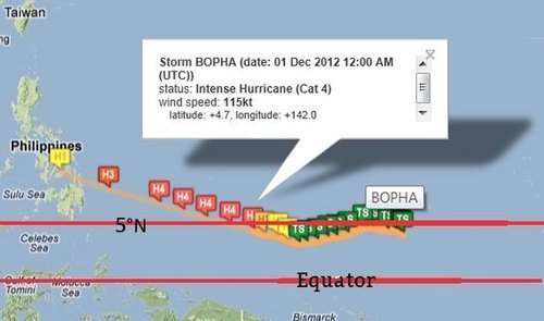
A strong typhoon dubbed Bopha has spun up in the Northwest Pacific Ocean this past week and is taking aim at the Philippines. The typhoon is currently located at 4.5°N which means that it’s still located within the Intertropical Convergence Zone (ITCZ). This is an area north and south of the equator where north-east and south-east winds meet and cause daily convectional thunderstorms. Near the equator, there is little Coriolis effect which would explain why tropical cyclones rarely form (lack of spin). Since Bopha will move towards the west north-west, it will hold together. If it were moving towards the equator, it would be less likely that it would maintain form.

Typhoon tracks

All typhoon tracks between 1985 and 2005 with equator and Bopha’s approximate location (pink). (Source: Wiki Images)

Bopha

Bopha’s basic into from Friday night, it’s expected track and strength. (Source: Humanitarian Early Warning Service)

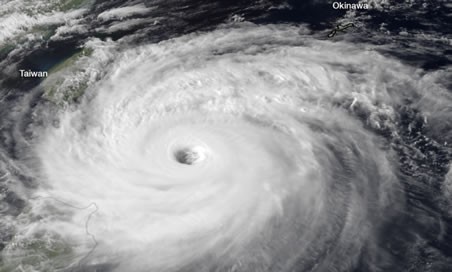
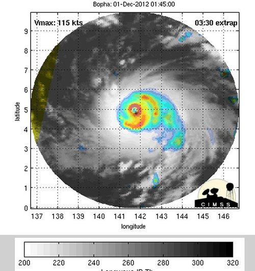
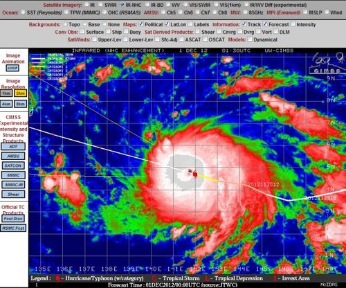
It’s expected that Bopha will strike south of Manila and likely make landfall on the Island of Samar on early on Monday, December 4th. It is likely to be a violent typhoon, bringing severe storm surge, copious amounts of rain to areas that are prone to mudslides and flooding. Winds will almost certainly be a problem as it’s predicted that Bopha will make landfall as a category 3, accompanied by winds around 200km/h. As of Friday evening the storm already had a central pressure of 965mb with sustained winds near 200km/h. On Friday evening, it was quickly intensifying with very cold cloud tops around its centre and a well-defined eye was starting to develop.

Microwave imagery - Bopha

Microwave imagery from Bopha on Friday night. The eye was becoming well defined. (Source: CIMSS)

IR Satellite - Bopha

Infra-red satellite imagery from Bopha as a category 4 hurricane. (Source: CIMSS)

On average, the Philippine Islands see an average of 9 hurricanes make landfall annually, with 1-2 usually developing in the month of December. Their peak season for typhoon activity runs at about the same time as the Atlantic Hurricane Season, though it’s not unusual to see typhoons in that area after November 30th.

Elsewhere in Weather News: September 29, 2012

Typhoon Jelawat Forecast to Weaken Before Impacting Japan

Typhoon Jelawat remains at very strong intensity despite weakening from its previous status as a super typhoon. Earlier this week Jelawat had maximum sustained winds of 220km/h near its centre, which would classify it as a category four hurricane by north american standards. The storm currently has maximum sustained winds of 145km/h (as of Friday afternoon), the equivalent of a category two hurricane.

Satellite image of Jelawat on Thursday morning when it was heading toward Taiwan with 155mph sustained winds

Satellite image of Jelawat on Thursday morning when it was heading toward Taiwan with 155mph sustained winds. (JMA/NOAA) – via Washington Post (see sources)

Jelawat is presently located near Okinawa and is moving in a north-easterly direction toward Japan, weakening the further north it moves. According to the Japanese Meterological Agency Jelawat will impact the Ryukyu Islands, including Okinawa, today before moving toward the Japanese mainland late today into Sunday.

Jelawat's Forecast track by the JMA

Jelawat’s Forecast track by the JMA

Thus far Jelawat has not caused any devastating damage, owing to the fact that it has not yet impacted any large land masses. Some damage was reported on Lanyu (Orchid Island), located just off Taiwan’s south-eastern coast. No casualties have been reported on Lanyu, but the harbor, gas station, and supermarket were reportedly destroyed. There may be more damage as this typhoon moves over the more heavily populated Ryukyu Islands this weekend.

Sources: http://www.taipeitimes.com/News/front/archives/2012/09/29/2003543923, http://www.hko.gov.hk/wxinfo/currwx/tc_gis_e.htm, http://www.washingtonpost.com/blogs/capital-weather-gang/post/typhoon-jelawat-closing-in-on-okinawa-japan-nadine-becomes-hurricane-again/2012/09/28/c0f6844c-097b-11e2-a10c-fa5a255a9258_blog.html

Elsewhere in Weather News: August 25th, 2012

Isaac Threatens Southern States

This past week a tropical disturbance in the central Atlantic, east of the Caribbean, has strengthened into a tropical storm – Isaac. As of Friday night, Isaac had sustained winds of 112km/h, a central pressure of 990mb and was eyeing (no pun intended) Haiti. It is especially worrisome that Isaac, a strong tropical storm, is moving towards one of the most impoverished countries in the world, where nearly 400,000 people are still living in tents after the major earthquake back in 2010.

Isaac

Isaac on infrared satellite with centre of circulation identified by arrow. Purple, red represents very cold cloud tops. (Source: WSI)

Isaac will make landfall as a strong tropical storm as it crosses Haiti and then heads toward Cuba. It might have trouble sustaining its strength due to the mountainous terrain of the islands but as it emerges into the Gulf of Mexico, Isaac should organize itself quickly as it takes aim at the Gulf States such as Florida, Alabama, Mississippi and Louisiana. It is expected that Isaac will make landfall on American soil, somewhere on the western part of the Florida Panhandle on Tuesday afternoon. By that time Isaac will have intensified enough to be of hurricane strength, most likely category one. Residents of the Gulf States will have to monitor conditions closely to secure items outside and be ready to evacuate; storm surge along the coast and flooding because of the heavy rains is likely to occur. It will not be uncommon to see rainfall amounts of 100-200mm in the hardest hit areas in the Caribbean and US, however, the more rugged terrain of the islands on the Caribbean could have more devastating effects; landslides and flash flooding.

Isaac track

Isaac’s projected track. (Source: News 13)

In other news around the world, Taiwan has been hit with yet another storm – typhoon Tembin that had sustained winds of 155km/h but struck a less populated area of the country, leaving the large cities like Taipei with only minor flooding and wind damage.

Elsewhere in Weather News: August 11th, 2012

Barrage of Typhoons Continue to Impact Asia

Haikui, the third typhoon to hit China this month, made landfall on Wednesday affecting over 100,000 people on China’s east coast. Rain, rain and more rain is what the region has experienced these past few weeks as typhoons Saola, Damray and Vincente (reported in previous EIWN posts) have all made landfall. On top of the severe rains brought on by these recent typhoons, Haikui has dumped an additional 200mm in areas where the grounds were already extremely saturated – inland flooding now adding another element of concern for residents.

Haikui track

Haikui’s track as it made landfall on China’s east coast. Forecasted track was as of Wednesday August 8th. (Source: TSR)

Thanks to China’s meteorological authorities who issued a red code warning (most severe) for the city of Shanghai well ahead of the typhoon hitting, many lives were saved as residents had time to vacate the premises. Authorities helped relocate over a million and a half people, mostly from the Shanghai region, before Haikui made landfall, further lessening the risk of casualties in the areas prone to flooding and landslides. Storm surge was also a concern for townships along China’s east coast.

Haikui

Satellite picture of Haikui as it made landfall just south of Shanghai. (Source: Earthweek)

In all, about one million acres of cropland and over six million of China’s residents have been impacted by this major typhoon. Flood damage has been extensive, ranging from roads washed out and stranding tourists and local residents, to homes being washed away by the flash floods. Estimated damage costs from this most recent typhoon are pegged at around the 1.5 billion dollars.

Haikui damage

One of many washed out roads caused by flash flooding in the Zhejiang Province. (Source: Global Times)

Six casualties have been associated with typhoon Haiku to date, however the death toll from the barrage of typhoons since the beginning of July, combined with heavy rains affecting the region, has brought the toll to over 100 people.