Elsewhere in Weather News: October 12th, 2013

India Braces for Super Cyclone Phailin

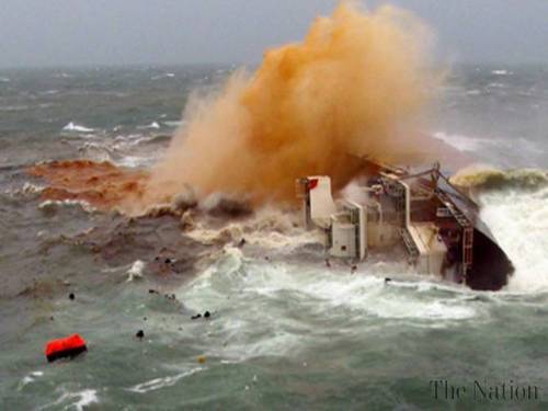
An extremely powerful cyclone churning in the Bay of Bengal is targeting India’s east coast and is expected to make landfall this morning. This is one of the strongest cyclones India has seen in recent history and the strongest since 1999. Phailin has maintained category five status since Friday afternoon and is expected to only slightly weaken to a high end category four (as its eyewall moves over land) before making landfall. Conditions were primed for quick intensification on Thursday; SSTs approaching the 30°C mark and shear quite low. Phailin went from a tropical cyclone to category four on Thursday thanks to these ideal conditions for intensification. Already, India has evacuated tens of thousands of residents from low lying coastal areas but Phailin still has the potential to wreak much havoc on India. Already one death has been reported associated with a tree falling onto a house as of Friday night.

Phailin

Incredible image of Phailin just before it makes landfall; a well defined eyewall and very cold cloud tops are present showing that the storm is well-organized. (Source: CIMSS)

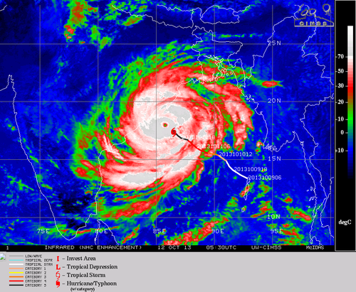
Storm surge will be a real problem with this cyclone – a forecasted 11 foot storm surge is expected to arrive as Phailin makes landfall near Brahmapur. The good news is that the coastline goes up in elevation fairly quickly as you move inland, therefore residents that should be most concerned with storm surge should be the ones that live near shorelines. With category five cyclones like this one winds as well as flooding problems are almost a given. In this case, winds will be sustained over 240km/h, gusting over 300km/h, and anywhere from 200mm to 350mm can be expected to fall around where Phailin makes landfall. The cyclone is expected to move inland and die off fairly quickly as it moves over land as opposed to being over warm ocean waters.

SST and shear

Sea surface temperatures, overlayed with shear. Note the low shear values (5-10 knots) and SSTs between 29°C and 30°C; sufficient to sustain category five storms. (Source: CIMSS)

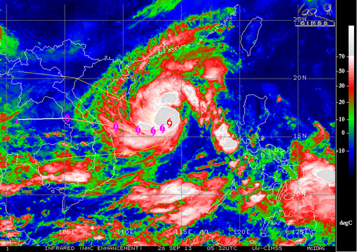
Another storm; typhoon Nari is currently threatening Vietnam to make landfall at the beginning of next week. It is still recovering from its passage over the rugged islands of the Philippines but is expected to strengthen to a category three typhoon over the South China Sea before landfall. Models are suggesting yet another typhoon to spin up behind Nari but this one is expected to take a turn towards Japan. So, overall a very active weekend and upcoming week cyclone and typhoon-wise!

Elsewhere in Weather News: September 29th, 2013

Wutip Forms, Typhoon Usagi Update

This week the Northwest Pacific typhoon season continues to be active as another typhoon – typhoon Wutip – has spun up in the South China Sea and is tracking westward. Although this is good news for the residents of Hong Kong and southern China who have been affected by last week’s typhoon, Vietnam will now have to closely monitor Wutip. As of Friday night Wutip was only a high-end tropical cyclone but is expected to slowly continue to strengthen over the open waters of the South China Sea. It will likely only have enough time to strengthen to a category one typhoon before it makes landfall near the city of Da Nang. Still, residents of Vietnam will have to watch for storm surge that could wreak havoc in low lying coastal areas as well as flooding; much rain will be associated with Wutip. It’s expected that Wutip will make landfall Sunday night.

Wutip

Infrared enhanced image of Wutip on Friday night. A bit of dry air to the south-east of it’s center but very cold tops (white) near it’s center as it was attempting to organize itself. (Source: CIMSS)

The storm talked about in last week’s EIWN, typhoon Usagi, has caused significant damage to coastal areas of China, in the Guangdong province. In total, 25 people have died in China due to landslides triggered by the heavy rains and storm surge. Search and rescue teams are still looking for survivors in the mud though, and cleanup efforts are now underway. Usagi made landfall 140km to the north-west of Hong Kong; there it brought with it sustained winds of 175km/h which gusted to over 200km/h. In Hong Kong over 200 flights had to be cancelled. Although once a powerful super typhoon, Usagi is no more as it moved over China’s mainland and fell apart this past week.

Elsewhere in Weather News: August 17th, 2013

Utor Update

Since last’s week update on typhoon Utor, much has happened. Utor first made landfall in the Philippines; it wreaked havoc as a high-end category 2 typhoon bringing sustained winds clocked at 170km/h with gusts exceeding 200km/h – making it the strongest storm this year in the area. Following that, it continued on through the South China Sea and made a second landfall as a strong tropical storm on the south shores of China.

Unfortunately, quite a bit of destruction was associated with this typhoon, especially in the Philippines region. Flash floods washed away homes in the central part of the Philippines and landslides were more of a problem in the northern region; due to a more mountainous terrain. Seven people have been casualties of the storm in the Philippines and 42,000 have been reported homeless because of Utor. In addition to causing grief to the Philippines, Hong Kong and part of China (mostly Guangdong province) had to take their precautions to keep residents safe. Stock markets as well as businesses were closed and 118 flights needed to be cancelled. One cargo ship also had to be abandoned at sea as it flipped because strong winds from Utor. All of the 21 crewmembers were airlifted to safety.

Utor damage

Ship flipped 90 degrees sideways because of strong winds of Utor. (Source: The Nation/AFP)

Disturbances in the Atlantic

Two areas of interest have formed in the Atlantic Ocean, one near the Cape Verde Islands and another off the Yucatan Peninsula. The first one near the Cape Verde Islands, named Erin, is of tropical storm force and is drifting west. It will be interesting to see how it interacts with dry air the next couple of days. There is a possibility it might not survive not only because of the dry air but also because of “cooler” sea surface temperatures near 26°C. The second area, a broad area of thunderstorms, is not of tropical storm force and may never become a tropical storm. There is much uncertainty where this system will make landfall and how strong it will get. Models show anywhere from Louisiana to Brownsville, Texas. Wherever it will make landfall it will be a big rainmaker though, bringing in very moist air from the Gulf of Mexico; PWAT values over two inches.

Erin

IR Satellite image of Erin as of Friday night. Quite a bit of dry air on the south part of the storm. (Source: CIMSS)

Elsewhere in Weather News: July 13th, 2013

Strong Typhoon Makes Landfall in Taiwan

A strong typhoon, Typhoon Soulik, has made landfall in northern Taiwan last night bringing heavy rainfall and strong winds in the order of around 160km/h – considered category two. Soulik, once a category four typhoon, encountered cooler waters before making landfall and Taiwan’s rugged terrain continues to tear it apart. It’s expected to cross the South China Sea and make a second landfall on China’s southeast coast as a tropical storm. Most models show it heading into China’s mainland weakening into a tropical depression and further on, a low pressure system. Although only a tropical depression, Soulik will bring copious amounts of rain into the mainland, prompting fears of possible flooding later this weekend.

Soulik

IR image of Soulik on Friday night. Expected track and intensity overlayed. (Source: CIMSS)

As of Friday night, electricity disruptions, 1 death and two dozen injuries had been reported. Around 8,500 people had been evacuated prior to Soulik making landfall because they lived in landslide-prone terrain.