Summer-Like Weather Set to Return

After a few days with below-normal daytime highs, a southerly flow is setting up to return early-summer warmth to Southern Manitoba; however, an upper trough will bring wet conditions to portions of Southwest Manitoba

Accumulated Precipitation from Thursday Evening to Saturday Evening

Total precipitation from Thursday evening through Saturday evening. Notice the sharp drop-off in precipitation amounts near the Red River Valley.

Under the influence of a strong arctic surface ridge, temperatures in Winnipeg have been 4 to 5°C below normal the past fews days. Fortunately, the low pressure system in Hudson Bay that has been blocking the ridge from moving out of our area is beginning to move off as it becomes caught up in a powerful storm system forecast to bring upwards of 50mm to portions of the Maritimes, including New Brunswick and Newfoundland.

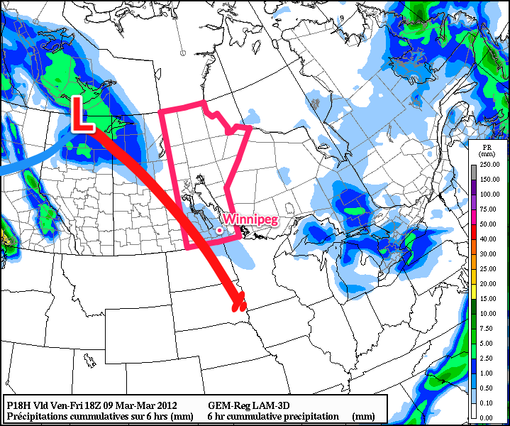
However, as the ridge moves off, a large upper trough will continue its trek into the Prairies, pushing into Saskatchewan over the next 36 hours. Multiple shortwaves are embedded in the trough, with two main ones to watch:

  • One shortwave is lifting northwards from British Columbia and will track eastwards near the 60th parallel.
  • A second shortwave will track along the base of the trough into Eastern Montana/Western North Dakota before becoming cut-off and stalling out.

For today, a large area of precipitation will link the two shortwaves, but weaken later in the day as they move further apart and the overall lift weakens a little bit. As the line of precipitation moves eastwards into Manitoba, it will also have to battle with the dry air flowing out from the high over the eastern portion of the province. This should keep most of the rain out of the Red River Valley, with only a slight chance of a passing sprinkle this afternoon and overnight right along the Western Escarpment.

We should see mostly sun today and tomorrow, with daytime highs near 12°C. Sunday will mark the beginning of the big warm up as the southern shortwave, after stalling out over Eastern Montana for a day or two, heads our way. We should see temperatures climb into the upper teens on Sunday with a mix of sun and clouds before the system moves in overnight.

For next week, Moday looks showery but then skies clear out and we’ll have beautiful weather for most of the week with highs near 20°C.

Saturday Rain Followed By A Warm Up

After a pleasant Friday, Southern Manitoba will see a showery Saturday as one last system pushes through the province before a large-scale shift in the upper atmosphere brings above-normal weather back to our neck of the woods.

500mb Speed Map

500mb Wind Speed map from the NAM depicting the strong jet core associated with a low forecast to track across Southern Mantioba.

For today, the Winnipeg & the Red River Valley will see sunny skies with milder temperatures, courtesy of the cold trough that we’ve been under the influence of the past few days finally moving off towards the east. We should see a daytime high of about 12°C today, which is right around normal for this time of year.

Tonight, clouds will roll in ahead of a system that is sliding across the Prairies. Showers will push into Southwest Manitoba this evening along a NW-SE line aligned with the lift associated with a strong 90kt jet streak at 500mb. This line will push eastwards through the night and enter into the RRV by morning. The showers should weaken and spread out into a band of light rain by the time it reaches Winnipeg. Although the rain won’t be particularly heavy, the system looks to be relatively slow moving, and because of that it seems like most areas in Southern Manitoba will see between 2-5mm of rain. We’ll refine rainfall amounts in the comments a little closer to the event.

The rain clears out on Saturday evening and clouds will scatter overnight. Skies should completely clear by Sunday afternoon through the RRV leaving us with sunshine and a high near 15°C.

For next week, temperatures will remain in the low teens as an upper ridge begins to build into the Southern Prairies, however we’ll have to wait and see how much sun we’ll have. The potential for several powerful systems to track across the Prairies exists; we’ll be sure to keep an eye on whether or not these systems will impact Winnipeg and the Red River Valley!

Warmer Weather To Round Out The Week

Southern Manitoba will see a much more pleasant second half to the work week as an Arctic high pressure system exits the region and allows warmer air to return to the region. Temperatures will moderate and rise to above normal by Friday before a complex weather setup brings showers this weekend.

Southern Manitoba has seen the coldest weather we’ve seen in quite a while. Sunday’s maximum temperature of -0.7°C was the coldest day we’ve had since the mercury topped out at -3.9°C on March 9th. The high pressure system responsible for the cooler temperatures brought a record daily overnight low temperature to Wynyard, SK on Monday morning where the temperature bottomed out at -18.0°C which beat out the old record of -15.6°C set in 1940 (records for Wynyard, SK began in 1940).

700mb Temperatures valid Wednesday Evening

700mb temperatures valid 00Z Wednesday Evening

With the main ridge axis through the Red River Valley, winds will begin to pick up out of the SE today as warmer air pushes in aloft. This, combined with plenty of sunshine, should allow our temperatures to rebound nicely to around 7°C this afternoon. Warm air will continue to push into our region in advance of an upper low trundling into the northwestern United States and push our daytime high up into the mid-teens for Thursday.

The weather will take a turn on Friday as showers develop overnight Thursday and push into Southern Manitoba Friday morning. Currently it looks like we’ll see just some light showers; remants of nocturnal convection from North Dakota moving along with an area of lift associated with a dying surface low. What actually happens will depend significantly on how the rain develops in North Dakota, so we’ll be sure to keep an eye on that. For now, enjoy the next couple days! Just don’t forget a jacket out there for this morning, it’s chilly!

The Warm-Up Begins

After a quick punch of snow and some extremely strong winds, as high as 75km/h, yesterday, Winnipeg is set to see a dramatic warm-up. Strong southerly winds will develop ahead of an incoming warm front, resulting in a chilly day today, however by Saturday and into next week, we’ll be seeing temperatures we haven’t seen since January! (Well, that’s an odd statement…)

Saturday 18Z Precip/Sfc. Analysis

6hr. Precipitation & Surface Analysis valid at 18Z Saturday

Our brisk morning will be replaced by seasonal temperatures with a stiff southerly wind around 40km/h preceding the arrival of a strong warm front. This will produce wind chill values between around -20 and -15 through the day today. We’ll have a slight chance of some light flurries midday as an area of lift ahead of the warm front passes through, then winds will diminish overnight as the warm front passes and our temperatures will rise to around 0°C. This will mark the beginning of steadily climbing temperatures over the next few days. On Saturday we’ll reach temperatures near 4°C.

Further on, our temperatures will be highly dependant on our snow cover. Many models want to push our temperatures up to nearly 10°C in very short order, however if our extensive snow cover doesn’t erode rapidly, we’ll be stuck with temperatures in the 4-5°C range. That being said, the warm temperatures should result in fairly consistent snowmelt and given that we’re expected to be embedded in a warmer air mass for the next week, we should see daytime highs consistently between 5-10°C!