This week will start out warm, but a bit unsettled thanks to a series of low pressure systems that will pass through the region, bringing variable weather conditions.
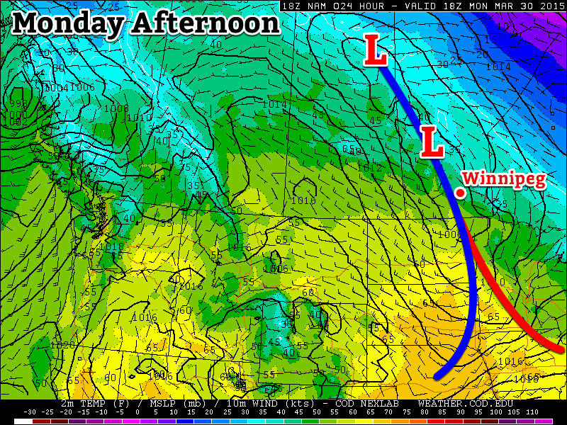
The first of a series of low pressure systems will pass through Manitoba on Monday
Monday
Monday
13°C / 0°C
Mix of sun and cloud with chance of showers
Today will be a mixture of sun and cloud as a low pressure system passes through the region. This low may generate some shower activity in southern Manitoba, but accumulations will be small. A cold front will pass through in the afternoon, causing winds to pick up from the north-west. Temperatures should climb into the low teens in most areas making for a warm but slightly unsettled day.
Tuesday
Tuesday
14°C / 5°C
Mainly sunny
Tuesday will be a nice day in southern Manitoba. There will be some cloud cover, but there should be more sun than cloud. Temperatures will climb into the low to mid teens with increasingly strong south winds. Overall, a pleasant spring day!
Wednesday
Wednesday
13°C / -2°C
Mainly cloudy with showers
Wednesday will see the return of unsettled conditions as another low pressure system approaches the region. This system will be quite powerful, but luckily most of the heavy precipitation (and that in solid form) will remain to our north. We will nonetheless see some shower activity and mainly cloudy skies. Winds will shift from southerly in the morning to westerly in the afternoon.
Long Range
The long range forecast continues to look quite variable. After Wednesday’s system exits the region we’ll see markedly cooler weather as cold air floods down from the north. Following this cool-down it appears that temperatures will hover around seasonal values, give or take a few degrees.
The brief cool-down in the wake of a relatively short-lived, but potent storm will come to an end this weekend thanks to another low pressure system moving across the Prairies that will bring a warm front across the province over the next couple days.
Friday
-1°C / -7°C
Mainly cloudy with a chance of flurries
Saturday
7°C / 1°C
Increasingly cloudy & windy
Sunday
7°C / -2°C
Clearing & windy
Today will see cloud moving in through the morning as a weak disturbance moves into western Manitoba. While this system will bring 2–4cm of snow west of the Red River Valley, here in Winnipeg we’ll see just a slight chance of a light flurry or two. Further west in the Red River Valley – near Portage la Prairie S/SE down towards Morden & Winkler – will likely see a bit of light snow today, but no significant accumulations from it. Winds will be around 20km/h or so out of the south and Winnipeg will see a high temperature near –1°C. Skies will clear this evening as temperatures head to a low near –7°C.
Saturday will be a warm but windy day as a warm front moves into the Red River Valley. Temperatures will climb to an above-normal[1] 7°C under increasingly cloudy skies. Winds will pick up fairly early in the day and strengthen out of the south to 40–50km/h.
Saturday Night
1°C
Rain overnight
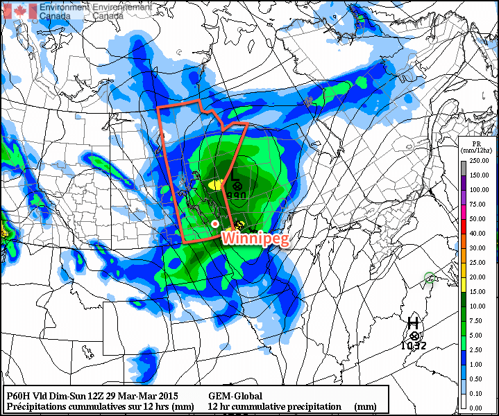
A low pressure system will track through Manitoba on Saturday night. The biggest impact from this storm will be felt in Central and Northern Manitoba where up to 10cm of snow may fall. Further south, we’ll see an area of rain move across the region beginning early Saturday evening and tapering off sometime mid-overnight.
Generally speaking, somewhere between 2–5mm of rain is likely to fall. Winds will taper off in the evening as the Red River Valley moves into the trough of this system, and then pick up again out of the northwest once the low passes. The wind will likely strengthen to around 40km/h by Sunday morning.
12hr. accumulated precipitation amounts forecasted by the GDPS for Saturday night.
Sunday will see clearing skies and a high once again near 7°C. Winds will remain strong out of the northwest at 40–50km/h into the early afternoon before tapering off.
Long Range
The long-range forecast looks quite nice through the first half of next week. Both Monday & Tuesday look to bring fairly sunny skies and highs somewhere in the 5–10°C range. Things take a bit of a turn mid-week when a low pressure system is forecast to move across the Prairies and potentially bring another snow event to the Red River Valley.
Normal daytime highs for this time of year in Winnipeg are near +3°C. ↩
Windier, snowier weather is on the way for Winnipeg and the Red River Valley, marking the start of a large-scale pattern shift which will bring the latest – and hopefully last – deep freeze to an end and allow more seasonal weather and temperatures to take hold.
Wednesday
-9°C / ⇑ -6°C
Windy & cloudy. Blowing snow possible. Snow in the afternoon.
Thursday
-1°C ⇓ / -18°C
Snow ending midday; breezy with temperatures falling in the afternoon.
Friday
-12°C / -20 to -25°C
Mainly sunny.
A Windy, Snowy Shift
Warmer air trying to build its way into the Red River Valley will result in increasing southerly winds today. By early this afternoon, winds will be quite strong out of the south at 40-50km/h with gusts as high as 70km/h. These strong winds – coupled with a fairly deep boundary layer – will likely produce fairly widespread blowing snow in the Red River Valley. It’s severity may be limited by relatively mild temperatures, however it’s best that anyone travelling on area highways be prepared for poor driving conditions.
Warmer air at 850mb (denoted by the yellow/red colours) will be pushing northeastwards over the next 24 hours.
By late in the afternoon, the upper-level portion of the warm front will be approaching the Manitoba border. A strengthening jet[1] overriding the 850mb baroclinic zone will provide a fair amount of isentropic lift. As the jet intensifies, as will the area of light snow pushing into Parkland Manitoba this morning. It will progress eastwards through the day and push through the Interlake and Red River Valley mid-to-late this afternoon.
It seems likely that Winnipeg will see around 2cm of snow that falls as a fairly intense, but short, burst. Areas south of the city will be more hit and miss as to whether or not snow falls. The safe thing to say is that you’re more and more likely to see snow the further north you are in the valley.
By evening our temperature will climb up to our daytime high of about -9°C. Overnight will bring the continued chance for flurries/light snow while winds diminish somewhat and temperatures continue to rise to around -7 or -6°C here in Winnipeg.
Expected storm-total snowfall by Friday morning. Snow will fall in 3 main batches.
Thursday looks to bring more snow to Winnipeg & the Red River Valley as a clipper system races along the Canada-US border. Snow will move in fairly early in the day, spreading eastwards along the Trans-Canada corridor into Winnipeg, and end early in the afternoon. In total, around 5cm is likely to fall through the morning hours – with a little less to the south of Winnipeg – while accompanied by breezy winds out of the south at around 30km/h. Winds will become gusty out of the NW at 30-50km/h in the afternoon as the system tracks off to our east.
Temperatures will climb to a positively balmy -2 or -1°C by midday before the northwesterlies begin drawing in cooler air.
Flurries & Cooler
Thursday night will bring a good chance of seeing some flurry activity as another ridge of high pressure builds in from the NW and some favourable snow-making air slides southeastwards through the region. Any accumulations would amount to only a couple cm at most, and through the night the clouds will break up and we’ll be left with partly cloudy skies by Friday morning.
Friday itself will bring cooler temperatures with a high of only around -12°C and light winds. Some cloud cover Friday night will help temperatures from dipping too much, with overnight lows dipping just below -20°C.
Spring Ahead?
Hope finally lies in the long-range models. Almost all are showing a high probability of a return to seasonal temperatures[2] within the next 2 weeks. No significant cold snaps are in the foreseeable future, and with the sun getting stronger and stronger and the days getting longer and longer, it doesn’t seem likely that we’ll see any more brutal cold snaps for the miserable winter of 2013-2014.
Don’t forget that this coming Sunday, March 9th at 2:00AM we get to do that wonderful[3] tradition of changing our clocks! We spring forward an hour, so it’ll be time to cash in that extra hour you banked way back in the fall!
A “jet” is a narrow ribbon of strong winds aloft. ↩
Which will be for daytime highs near -3°C and overnight lows near -13°C. ↩
After what will be going down in the record books as one of the coldest, if not the coldest, April on record, the weather is poised to dramatically shift gears. After being stuck in “March” for far too long, it looks like we’re poised to skip right over “April” and shift into “May” in very short order.
850mb temperatures from the NAM show temperatures approaching 15°C advecting into Southern Manitoba on Saturday morning.
Southern Manitoba has been locked in March-like weather temperatures routinely 8–12°C below normal as a persistent northwest flow aloft has continually reinforced the Arctic air mass sitting over the region. This has led to some impressive new records including the latest date in the year that Winnipeg[1] has hit it’s first +5°C temperature. This has led to a substantial snowpack remaining through the Red River Valley and we’re on our way to the latest flood peak for the Red River; in Winnipeg the Red is expected to peak in late-May, 1–2 weeks later than the previous latest-peak on record which was May 19, 1950.
We’re set to bust out of the cold, though, as a huge shift in the upper-level pattern is on the way.
2°C / -10 Scattered flurries in the morning. Mix of sun & cloud.
Today will continue our trend of cool weather as yet more cold air will be descending southwards through the province. A cold front will pass through Winnipeg in the morning and through the Southern Red River Valley in the afternoon. The cold front will likely have some scattered flurries along it as it pushes through in the morning and then develop more organized, heavier convective flurries along it in the afternoon, south and east of Winnipeg. There will be a very slight chance of some light flurry activity behind the cold front, but that will be minimal as the atmosphere quickly stabilizes behind the front despite daytime heating. Skies will clear out through the afternoon and we’ll be headed to a chilly –9 or –10°C tonight.
Thursday & Friday
A huge change is on the way for the end of the week. The high over low block we mentioned last week will finally break down as the cold low associated with the feature ventures towards the Central Plains of the United States. The upper ridge begins to collapse over the Eastern Pacific and the upper flow rapidly breaks down and becomes zonal, dramatically shifting storm tracks. By Wednesday evening, a new low will already be moving into Northern Alberta. Over the past few weeks, stuck in a northwest flow, such lows would generally slice SE through Saskatchewan and push into the States before reaching Manitoba. Under this new flow regime, though, this low will push through Central Manitoba instead, helping pull warmer air into southern portions of the province. Just how warm, you ask?
Thursday 8°C / -2°C Mainly sunny.
Friday 15°C / 3°C Sunny.
Temperatures will soar over the next few days as warm air that not even the snowpack can fight against floods it’s way northward. We’ll see temperatures climb to 7 or 8°C Thursday as the southwest flow sets up and the warm air is able to start pushing into Southern Manitoba and then see temperatures be close to double that on Friday as we get deep into the warm air. No precipitation is expected either day.
Long-Range
It looks, more or less, like warmer air is here to stay. Warm air will continue to build into the province through the weekend pushing temperatures closer and closer to the 20°C mark. We’ll likely have a couple nights with lows well above 0°C. A disturbance will return cooler air to the province at the start of next week, but it’s not expected to stick around for too long.
Flood Concerns
Flooding concerns will arrive en masse with the warmer weather. The dramatic and intense warm-up, combined with a high likelihood of overnight lows above 0°C this weekend mean that the remaining snowpack will undergo rapid melting. Some overland flooding should be expected, and anybody living near rivers or streams should expect them to swell quickly this weekend into the beginning of next week. In Fargo, the Red River is expected to rise from 20’ on Friday night to around 32’ by Monday morning. The Red River isn’t expected to peak in Winnipeg until late May, but one thing is for sure: the water will be flowing by the end of the weekend all over the Red River Valley, so be sure to take adequate precaution when around swollen rivers or streams.
The observing site CYWG at the Richardson Int’l Airport. ↩


