First Moderate Risk of 2013, Tornadoes in Southern US
A severe weather outbreak occurred this past week across a large part of the southern United States. The outbreak was well forecasted by the SPC as they issued a ‘moderate risk’ warning in their two-day outlook. With a strong gulf flow bringing in copious amounts of moisture, dewpoints rose into the mid-sixties, creating enough instability for thunderstorms. This, coupled with a very strong low-level jet, much shear, and an approaching trough of low pressure, created conditions ripe for dangerous storms.
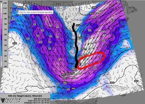
Taking both January 29th and 30th weather activity into consideration, 41 tornado reports and over 600 high wind reports were submitted. These high wind reports can be attributed to winds reaching 130km/h just above the surface, associated with the low level jet (850-925mb), and brought down to surface in thunderstorms.
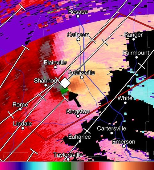
The strongest tornado to occur in this outbreak appears to have been the Adairsville (Georgia) Tornado, which was a large wedge tornado and rated by the NWS to be of high-end EF-3 strength (10km/h short of EF-4). This tornado was spawned by a supercell that was slightly ahead of the front and its inflow was not disturbed by any other cells in the area. The tornado’s track was about 35km long and was nearly one kilometer wide. Severe damage was done to the town of Adairsville, where around 60 buildings were destroyed, one person lost their life, and another 17 were injured.
The large low pressure system not only caused grief to the southern states, but it also created issues on the back side of the low pressure system where flash freeze weather caused large pileups on interstates. The northern half of the US Midwest received 20cm of snow.
There are signs that another trough might emerge from the Rockies late next week and into the weekend, and bring with it another round of severe weather to the southern US. There is much uncertainty as to the timing and exact location as there is still a fair amount of time until the event.