There will be only a couple days of sun before the threat for rain returns to the Red River Valley.
After a few unsettled days across Southern Manitoba which, depending on where you were, brought anywhere from no rain to upwards of 15-25mm, the weather is set to offer refuge from the gloom in the form of sunshine and perhaps the warmest temperatures we’ve seen all year. Unfortunately, the pleasantries will be cut short when another complicated weather set-up involving a large cut-off upper low and multiple impulses travelling northeastwards out of the United States redevelops.
Friday
Today will be a pleasant day with mainly sunny skies and winds out of the northwest at around 20km/h. The temperature should reach a high around 15 or 16°C, which will likely be the warmest day in Winnipeg since we hit 15.1°C on April 23rd. Unfortunately, this will still be 2-3°C below our seasonal normal.
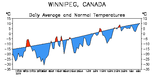
Despite the temperatures warming up slowly, the fact that we’ve spent such an unbelievable amount of time with temperatures below normal is what is driving many in Winnipeg to dream of warmer climes. Even last year, which had the latest snowpack melt on record[1] had already seen temperatures as high as 26°C by this point.
Unfortunately, I don’t have much good news in that department.
Saturday
Saturday will be the nicest day of the year so far, hands down. Skies will be mostly sunny until the cloud shield associated with the next low pressure system begins creeping into the region in afternoon or evening. Winds will be out of the south at around 20-30km/h and the temperature will skyrocket to take the top spot of 2014 so far…at a seasonal 18-19°C![2].
Saturday night will be mainly cloudy with a chance for showers pushing into the southern Red River Valley overnight. The temperature will drop to around 7°C.
Sunday
Sunday will bring a return to cooler, wetter weather as the weather pattern shifts back into a more unsettled regime. It’s a bit early to get too specific, but it seems likely that some light rain is likely as a low pressure system meanders into the Red River Vally from southwestern Manitoba. The high will be close to 12°C and the low will dip down to 2-3°C.