Saskatchewan Chase July 24th
An unusually strong upper level low for this time of the year nosed into the southern Prairies and was the focus for severe storms last Thursday. All the ingredients were present for severe storms that day, as Brad alluded to in his discussion of the event posted on the day of. Keeping in mind that this might be one of the last chases this season, due to the jet stream slacking up, a few of us made our way into Saskatchewan to chase the storms.
The day was off to somewhat of a surprising start as we woke up early to find a large squall line was sweeping across southeast Saskatchewan, southwest Manitoba and North Dakota. Thankfully, as the squall line moved away from the main instability axis in the morning it started weakening and its leftover cloud wouldn’t hamper our chances in Saskatchewan for the surface based storm development in the afternoon. After determining that skies would clear in the south-central part of Saskatchewan by late morning, the chase was on. From Winnipeg we drove straight to Brandon, grabbed a quick bite to eat and from there made our way to Weyburn, SK. After arriving in the mid-afternoon, we took a quick look at the satellite only to see some bubbling cumulus and even towering cumulus well to our southwest. By then it was obvious that nothing would fire in the Weyburn area with a stout cap present and no trigger around.
We then had to make a decision to either call it a day or head to south-central SK – where there was plenty of upper forcing and a cold front in the region (further west than what the models were showing). Since we were already that far into SK, we went all in and drove a good 100km west to the Assiniboia region. By the time we got there a couple supercells had already fired; we picked the one that looked best (just south of Assiniboia) and stuck to it.
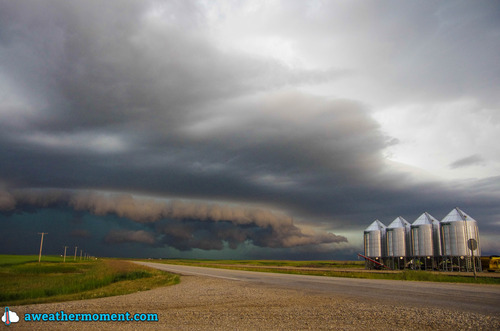
Following it for over two hours, we were able to spot two funnel clouds. One may have touched the ground, but we were too far away to tell (hence lack of pictures) while the other a brief funnel that spun up later in the evening on the leading edge of a bow echo. We followed the storm which evolved into a line with multiple bow echos embedded along it. Later in the evening the line became elevated, eliminating the wind threat but still able to produce a lot of cloud to ground lightning. The complex eventually died off in southwest Manitoba and left a large area of stratiform rain in the area.
Overall it turned out to be a fun chase day, with a storm that teased us with a few funnel clouds, combined with good structure and a nice light show. What we didn’t see from that day were the large hailstones that were later reported as well as strong wind gusts of 119km/h reported in Assiniboia.