2016 will be remembered for its overly generous warmth, thunderstorms and precipitation. It was a high-impact year for southern Manitoba. Here at A Weather Moment, we have prepared a list of what we think were the top 10 weather stories of 2016. Keep in mind it may not be ordered perfectly for everyone – some people may have been affected more by some events than others. Nonetheless, here they are!
#10 – Rainiest Halloween on Record Fitting End to Rainy October
It was an unusually wet October across southern Manitoba with numerous rainfall events. In Winnipeg, 64.1 mm of rain was recorded at the Richardson International Airport, the 14th rainiest October since 1872 and the rainiest since 1997. However, the heaviest rains fell in southwestern Manitoba where a wide swath from Brandon to Dauphin easily had the rainiest October on record. In Brandon, 118.3 mm of rain fell, breaking the previous record of 72.9 mm in 1898. More than 135 mm of rain fell in Dauphin, breaking the previous October record of 85.3 mm in 1982. These amounts exceeded the previous records by a remarkable 55% to 65%.
The heaviest rains came down with a significant storm system on October 3 and 4. Widespread thunderstorms and heavy rains pushed through southwestern Manitoba, dumping a general 50 to 100 mm of rain. This meant that for some locations, this two-day event was sufficient to reach the rainiest October on record! The highest amounts fell from the Riding Mountains southwestward to the Hamiota area where locally up to 150 mm of rain was recorded. Overland flooding was an issue and the province had issued flood watches for portions of the province as a result. The thunderstorms that the event brought were also unusually strong for October. Wind gusts of 70 to 85 km/h and pea sized hail were recorded along the US border.
The rain kept coming throughout the remainder of October with multiple rain events. In fact, two record rainfalls occurred in Winnipeg. 14.4 mm fell on October 23, breaking the old record of 12.5 mm in 2012. 15.8 mm fell on October 31, breaking the old record of 11.6 mm in 2000 and making it the rainiest Halloween on record.
#9 – July 20 Record Humidity a Highlight of Third Most Humid Summer
With an average dewpoint temperature of 13.7°C, summer 2016 tied with 2005 for 3rd most humid summer since 1953 in Winnipeg. Only the summers of 2010 (14.3°C) and 2012 (14.1°C) were more humid. The following graph shows average summer (June-July-August) dewpoint temperature per year since 1953 in Winnipeg.
Despite the high humidity on average, only three dewpoint records were broken over the summer (two record highs and one record high minimum). This showed that it was consistently humid but mostly not humid enough to break records.
July 20 was the most humid day of the summer as unusually high humidity pushed dewpoint temperatures close to all-time highs. Winnipeg International Airport recorded a dewpoint of 25.9°C, the second highest dewpoint temperature of all time since 1953. This was just shy of the all time high dewpoint of 26.1°C on July 17, 1966. It also smashed the daily record of 23.6°C in 2011 and was the first occurrence of dewpoint over 25°C since a 25.7°C reading on July 19, 2011. Even higher dewpoint temperatures of 27°C were recorded in Carman, Winkler, Portage la Prairie, Altona, Beausejour and Minnedosa. The maximum recorded dewpoint temperature was 27.4°C in Carman. The humidity combined with temperatures in the low thirties brought humidex values to the mid 40s. In Winnipeg, humidex topped out at 44.1, the 12th highest humidex value on record since 1953.
#8 – May 5 Heat a Highlight of Warmest May in More Than Two Decades
May 2016 defied the trend of cooler Mays which began almost 25 years ago. For the first time since 1991, we had a May that was among the top 30 warmest Mays since 1872. May 2016 averaged 14.0°C, 2.6°C above the 1981-2010 normal and tied with 1986 for 14th warmest May since 1872. In fact, it was the first May to average over 1°C above normal since 1991. Nine Mays since 1991 averaged over 1°C below normal. The graph below shows average mean temperature in May per year since 1872. Notice the absence of warm Mays since the early 1990s.
The month was highlighted by an extreme ‘burst’ of heat on May 5. Temperatures soared to the mid 30s across southern Manitoba as a hot and dry southwesterly flow ushered in record temperatures. Winnipeg reached 35.2°C, smashing the previous record of 31.7°C in 1926. It was also the earliest date to reach 35°C on record since 1872, beating the previous earliest date of May 8 in 1874. The high was also 37.5°C warmer than the low temperature the previous day, the 3rd largest such spread since 1872. Temperatures only reached a seemingly chilly 19°C the following day (May 6).
The 35.2°C high on May 5 also happened to be the hottest day of 2016, the earliest date to reach the highest temperature of the year since 1872. Previous earliest was May 7, 1891 with a high of 34.4°C. It was also only the 12th time the hottest day of the year was in May.
#7 – Early Spring Brings Record Warmth, an Early Melt and Record Rainfall
Spring came early to southern Manitoba for the second year in a row as temperatures soared above freezing in early and mid March. The winter snow pack was already thin and so, snow cover dissipated quickly with the warmth. Ground was already mostly bare in the Winkler area and southward in early March thanks to a dry and warm winter. Areas further north saw snow pack dissipate by mid March.
Temperatures reached double digits in the Morden and Winkler area on March 6 with a high of 11.0°C in Morden. Winnipeg reached 6.6°C. These were not records, however. Further west, Saskatchewan was experiencing incredible warmth on March 6. Regina reached 17.3°C, the earliest date to hit 17°C on record since 1884. This was almost two weeks earlier than the previous earliest date of March 18 in 1910.
The record warmth arrived in the March 11 to 14 period with temperatures reaching well into the teens across southern Manitoba. Winnipeg’s high of 12.2°C on March 12 broke the old record of 9.7°C in 2012. March 11 and 14 also reached double digits but were just shy of records. In fact, the high of 13.1°C on March 14 was just shy of the record of 13.2°C set in 2015. The Morden-Winkler area was warmest in the RRV with highs in the high teens. Three record highs were broken in Morden with highs of 16.0°C, 16.2°C and 18.5°C on March 11, 13 and 14 respectively. The high of 18.5°C on March 14 was especially remarkable. It broke the old record of 18.3°C set in 2015. What is remarkable is that the record before 2015 was just 11.2°C in 2012. To break an old record by more than 7°C two years in a row is beyond extreme! Not to forget mentioning that the record for the date was broken three times in 5 years!
Morden MB the national hot spot with a high of 18.0C as of 2 pm. Record for the date is 18.3C set just last year! pic.twitter.com/eJB38G98uu
— Rob's Obs (@robsobs) March 14, 2016
Melita, Manitoba hit 20.5°C on March 14, the earliest known date to hit 20°C on record anywhere in Manitoba. Previous known record was March 16, 2012 when multiple locations hit 20°C.
Snow depth reached 0 cm in Winnipeg by March 15, tied with 1995 and 2015 for 3rd earliest snow melt since 1955. 2nd earliest was 2012 with snow depth reaching 0 cm by March 14. It is interesting how we have had a clustering of very early springs this decade…
The warm spell in March also brought some unusually heavy rainfall and thunderstorm activity. Weak thunderstorm activity occurred near Selkirk on March 7 and near Sprague on March 8. Stronger thunderstorms occurred in southwestern Manitoba on March 14 and throughout southern Manitoba on March 15 associated with a significant low pressure system. Pea to dime sized hail and frequent lightning was reported in the Killarney area, a very unusual occurrence in Manitoba that early in the year. Widespread rains soaked southern Manitoba on March 15 as well, causing overland flooding atop still frozen ground. States of emergency were issued southwest of Steinbach as a result of the flooding. 15.7 mm of rain fell in Winnipeg, breaking the old record of 11.4 mm in 1946. It was among the top 10 heaviest rainfalls for so early in the year.
In the end, March averaged -2.0°C in Winnipeg, the 12th warmest March since 1872.
#6 – Strong El Nino Brings 9th Warmest Winter
One of the strongest El Niños on record had a profound impact on our winter in Manitoba. With an average mean temperature of -11.3°C in Winnipeg, it was the 9th warmest winter on record since 1872. The table below lists the top 10 warmest winters since 1872 in Winnipeg.
Top 10 Warmest Meteorological Winters (Dec-Jan-Feb) in Winnipeg Since 1872
| Rank | Mean Temperature | Year(s) |
|---|---|---|
| 1 | -7.2°C | 1877-78 |
| 2 | -8.2°C | 1997-98 |
| 3 | -9.5°C | 1986-87 |
| 4 | -9.7°C | 2011-12 |
| 5 | -10.1°C | 1930-31 |
| 6 | -10.8°C | 1991-92, 2005-06 |
| 8 | -10.9°C | 1982-83 |
| 9 | -11.3°C | 2015-16 |
| 10 | -11.6°C | 1999-00 |
There was a notable lack of cold days with just 30 days dipping below -20°C from December 2015 to February 2016. This was well below the 1981-2010 normal of 46 days and tied with the winter of 1918-19 for 8th least -20°C days since 1872. In addition, only 1 day dipped below -30°C, the third least -30°C days since 1872. The winters of 1930-1931 and 2011-2012 were the only ones to not see one day below -30°C and this winter was the only one to see just 1 day below -30°C. The 1981-2010 normal is 13 days below -30°C.
Cold spells were short and warm spells were frequent and long-lasting. The ground was mostly bare along the US border for much of the winter because snowfall was minimal and warm temperatures and even rainfall melted what little snow was on the ground. Temperatures were frequently above freezing as a result. Despite this, Winnipeg’s international airport only saw 8 days above freezing in January and February, which is close to normal. This was likely partly the result of snow cover in the area. Nonetheless, Winnipeg still managed to experience its 9th warmest December, 29th warmest January and 22nd warmest February since 1872. December saw the most extreme warmth with record temperatures across southern Manitoba in the first half of the month.
See our special State of the Climate post back in March for the full story on the 2015-2016 El Nino winter.
#5 – 5th Warmest Year Since 1873
With an average mean temperature of 4.6°C, 2016 tied with 2012 for 5th warmest year since 1873 in Winnipeg.
Top 10 Warmest Years Since 1873 in Winnipeg
| Rank | Average mean temperature | Year |
|---|---|---|
| 1 | 5.4°C | 1987 |
| 2 | 5.3°C | 1931 |
| 3 tie | 4.7°C | 1878 |
| 3 tie | 4.7°C | 1998 |
| 5 tie | 4.6°C | 2012 |
| 5 tie | 4.6°C | 2016 |
| 7 | 4.5°C | 2006 |
| 8 | 4.4°C | 1981 |
| 9 | 4.3°C | 1999 |
| 10 | 4.2°C | 2015 |
This was the 5th year since 2006 to be in the top 10 warmest years (2006, 2010, 2012, 2015 and 2016). Note that 2010 was in the top 10 until 2016 knocked it off the list (2010 averaged 4.1°C).
Ten out of twelve months averaged above normal in 2016. Only April and July averaged below normal. April was the most abnormally cool with an average of 2.8°C, 1.7°C below normal. July was just 0.4°C below normal with an average of 19.2°C. November was most above normal with an average of 3.1°C, 7.7°C above normal and the warmest November on record.
2016 featured a longer summer than usual. Five consecutive months, from May to September, saw daytime highs average over 20°C. This was only the 8th time this occurred since 1872 and the first time since 1989.
Five daily record highs were reached in 2016: one in March, one in May and three in November (including one tie). This was the most record highs in a year since 2012 when nine record highs were reached. So far this decade (since 2010), we have broken 27 record highs in Winnipeg. In the same period, we have only broken four record lows. This goes to show the extreme warmth we have experienced this decade. Although we have seen extreme cold, extreme warmth was far more common. The following graph shows the number of daily record highs and lows per decade since the 1870’s in Winnipeg.
Most impressive in 2016 was the daily minimum temperatures. Daily lows averaged -0.7°C in 2016, the 3rd warmest on record since 1873. Only 1987 (-0.2°C) averaged warmer.
Also impressive was the lack of cold in 2016. Only 112 days dipped below -5°C, the least -5°C days on record since 1872, beating the previous record of 118 days in 1878. In addition, only 3 days dipped below -30°C, tied with 1960 for 4th least.
With an average dewpoint of 0.2°C, 2016 also tied with 2010 for 3rd most humid year on record since 1953.
#4 – 2nd Warmest Fall on Record
With an average mean temperature of 8.0°C in Winnipeg, it was the 2nd warmest fall on record since 1872. Fall 2016 was second only to fall 1963 which averaged 8.6°C and featured the warmest October on record. Fall 2016 featured the warmest November on record. September and October were also warm, both averaging 1.5°C above normal. The following table lists the top 30 warmest falls by average high temperature, mean temperature and low temperature.
| Rank | Daily High (°C) | Daily Mean (°C) | Daily Low (°C) |
|---|---|---|---|
| 1 | 15.0 (1963) | 8.6 (1963) | 3.3 (2016) |
| 2 | 13.2 (1923) | 8.0 (2016) | 2.9 (1931) |
| 3 | 13.0 (1948) | 7.9 (1931) | 2.3 (1953) |
| 4 | 12.8 (1931) | 7.5 (1923) | 2.3 (1963) |
| 5 | 12.8 (2009) | 7.3 (1953) | 2.0 (1922) |
| 6 | 12.8 (2016) | 7.3 (2009) | 2.0 (2015) |
| 7 | 12.6 (1920) | 7.3 (2015) | 1.9 (1923) |
| 8 | 12.6 (2011) | 7.2 (1948) | 1.7 (1914) |
| 9 | 12.6 (2015) | 7.1 (1914) | 1.7 (2009) |
| 10 | 12.4 (1914) | 7.1 (1920) | 1.5 (1920) |
| 11 | 12.2 (1953) | 7.0 (1922) | 1.5 (1944) |
| 12 | 12.1 (1994) | 6.8 (1994) | 1.5 (1994) |
| 13 | 12.1 (2001) | 6.8 (2011) | 1.4 (1908) |
| 14 | 12.0 (1906) | 6.6 (2004) | 1.4 (1948) |
| 15 | 12.0 (1938) | 6.5 (1940) | 1.3 (1940) |
| 16 | 11.9 (1899) | 6.3 (1908) | 1.3 (1954) |
| 17 | 11.9 (1922) | 6.3 (1962) | 1.2 (1934) |
| 18 | 11.9 (2004) | 6.3 (2001) | 1.2 (1981) |
| 19 | 11.7 (1940) | 6.2 (1899) | 1.2 (2004) |
| 20 | 11.5 (1962) | 6.2 (1981) | 1.1 (1912) |
| 21 | 11.5 (2005) | 6.1 (1906) | 1.0 (1962) |
| 22 | 11.3 (1908) | 6.1 (2005) | 1.0 (2011) |
| 23 | 11.3 (1909) | 5.9 (1944) | 0.9 (1968) |
| 24 | 11.3 (1990) | 5.9 (1998) | 0.8 (1983) |
| 25 | 11.3 (1998) | 5.8 (1904) | 0.7 (1949) |
| 26 | 11.3 (1999) | 5.7 (1938) | 0.7 (2005) |
| 27 | 11.2 (1952) | 5.7 (1954) | 0.6 (1956) |
| 28 | 11.2 (1981) | 5.7 (1968) | 0.6 (1960) |
| 29 | 11.2 (1987) | 5.6 (1912) | 0.5 (1904) |
| 30 | 11.1 (1897) | 5.6 (1943) | 0.5 (1928) |
Thanks to a warm fall, both the first frost and accumulative snowfall of the season were significantly delayed. Winnipeg did not see its first freeze of the season until October 8, tied with 1897 and 1922 for 5th latest first freeze of the fall season since 1872. The first accumulative snowfall (0.2 cm or more) did not arrive until November 22, the latest date on record since 1872, beating the previous record of November 21 set in 1963. This was more than a month later than the 1981-2010 normal of October 18. It also meant Winnipeg went 225 days without measurable snowfall (April 11 to November 21), the third longest snow-free period since 1872. The longest such period was 232 days in 1998, also a year on the heels of a strong El Nino.
| Rank | Date of First Measurable Snowfall (≥ 0.2cm) | Year |
|---|---|---|
| 1 | November 22 | 2016 |
| 2 | November 21 | 1963 |
| 3 | November 20 | 1953 |
| 4 | November 19 | 1931 |
| 5 tie 5 tie | November 18 November 18 | 1880 2015 |
| 7 | November 17 | 1890 |
| 8 | November 16 | 1977 |
| 9 | November 15 | 1903 |
As mentioned, fall 2016 featured the warmest November on record. This period saw a total of 49 consecutive days of above normal temperatures, from October 21 to December 8.
It was also the most humid fall on record with an average dewpoint temperature of 4.4°C, beating the previous record of 3.6°C set in 2009. November was the most humid on record while both September and October were 5th most humid since 1953. A total of 18 record high and high minimum dewpoint records were broken: 12 in November, 5 in October and 1 in September. This included the all-time high dewpoint for November of 12.3°C on November 6. The previous all-time high for November was 11.1°C on November 5, 1956.
#3 – Two Snowstorms Push December to 2nd Snowiest Since 1872
After our warmest November on record, winter made its appearance known in December with significant amounts of snow. Two major Colorado Lows dumped over 25 cm of snow in Winnipeg and much of southern Manitoba in December.
Although it is not uncommon to be hit by major Colorado Lows in southern Manitoba, it is quite unusual to be hit twice in a single month by a storm of that severity. In Winnipeg, there has only been two to four other months since 1872 that saw two storms with 25 cm or more snowfall: January 1916 and November 1958 and possibly February 1881 and December 1909 (cannot confirm the last two due to limited information).
The two snowstorms occurred on December 6 to 8 and December 25 to 26. Each dumped about 25 to 35 cm of snow in Winnipeg and was combined with sustained winds of 35 to 50 km/h and gusts as high as 60 km/h. Winnipeg came close to official blizzard criteria but did not quite make it. A blizzard is defined as at least four hours of visibility of 400 metres or less in blowing snow along with winds of 40 km/h or more. We came closest on December 26 with four consecutive hours of visibility of 400 metres or less. The event did not qualify, however, because the sustained winds of 30 to 40 km/h were just shy of the criteria of 40 km/h or more.
On December 6, winds were strong enough but visibility hovered around 800 metres, just shy of the 400 metre threshold. Nonetheless, conditions were severe, especially outside the city where drifts around some properties reached more than one or two metres in depth. Most major highways were closed during both snowstorms, including highways 1, 2, 3, 59 and 75. Flights were also cancelled at Winnipeg’s international airport.
Final total downtown is 23 cm. now the fun begins as the wind starts to ramp up #mbstorm pic.twitter.com/PEkzdVhfX4
— Michelle Lang (@michecurry) December 26, 2016
In total, 68.8 cm of snow fell in Winnipeg in December, the second snowiest December since 1872. This was second only to 101.3 cm in December 1909. It was also the 7th snowiest month on record and the snowiest month since November 1958 when 77 cm fell. The following table lists the top 10 snowiest months since 1872 in Winnipeg.
Top 10 Snowiest Months Since 1872 in Winnipeg
| Rank | Snowfall | Month and Year |
|---|---|---|
| 1 | 101.3 cm | December 1909 |
| 2 | 89.9 cm | February 1881 |
| 3 | 85.3 cm | January 1916 |
| 4 | 80.3 cm | November 1955 |
| 5 | 77.2 cm | November 1958 |
| 6 | 76.2 cm | March 1904 |
| 7 | 68.8 cm | December 2016 |
| 8 | 67.8 cm | March 1909 |
| 9 | 65.0 cm | March 1935 |
| 10 | 64.3 cm | March 1898 |
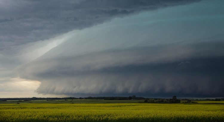
#2 – High-Impact Thunderstorm Season
Summer 2016 will be remembered for its relentless thunderstorms which produced several tens of millions of dollars in damage across southern Manitoba. According to Environment and Climate Change Canada (ECCC), Manitoba had the greatest number of severe weather reports of the three Prairie provinces in all categories, including tornadoes, large hail (nickel sized or larger), flooding rains (50+ mm in 1hr or less) and damaging winds (90 km/h or greater). In its report, ECCC mentioned 18 tornado events in Manitoba this summer, the greatest number in a couple of decades and the most in Canada in 2016.
There were a number of multi-tornado events including 4 tornadoes on August 8, 3 on July 20 and 3 on August 3. Some of these tornadoes hit communities, causing significant damage of which some areas are still recovering from. Close to a hundred people in Long Plain FN were still out of their homes as 2016 had come to a close. According to CBC, Long Plain Chief Dennis Meeches had called the July 20 storm, which spawned the tornado, the worst disaster in the community’s history with recovery expected to cost close to five million dollars.
The Glenboro area, Waywayseecappo First Nation, New Rosedale Hutterite Colony and the Erickson area were all hit hard by tornadoes in 2016 as well.
Severe thunderstorm events occurred every few days throughout almost the entire summer across southern Manitoba. A number of events stood out, such as the June 24/25 derecho and Whiteshell flood event, the July 20 wind event and tornadoes, and the August 3 and 8 tornado events. These four events are already described in the summer 2016 State of the Climate post, so head over there to view all the details.
Here are a few additional highlights of the 2016 summer thunderstorm season:
June 9 Selkirk Flood: Severe thunderstorms developed in southwestern Manitoba and southeastern Saskatchewan late afternoon on June 9 and tracked into Manitoba in the late afternoon and evening hours. The storms dropped toonie to golf ball sized hail and produced wind gusts of 90 to 105 km/h from the Virden area southeastward to the Deloraine and Killarney areas. Some property damage occurred as a result.
A training thunderstorm also caused flooding north of Winnipeg in the Selkirk area in the late evening hours. 35 to 45 mm of rain fell in less than an hour, causing significant flash flooding. Many roads, fields and basements were flooded.
This farmer's field just outside #SelkirkMB looks more like a lake today after last night's storm. #Mb #Mbstorm pic.twitter.com/hxmwkFP8Rk
— Selkirk Record (@SelkirkRecord) June 10, 2016
June 17 Red River Valley Hail and Torrential Rain Event: Severe nocturnal thunderstorms moved into south-central and southeastern Manitoba in the overnight hours dropping large hail and significant amounts of rain. Loonie to tennis ball sized hail fell from the Morden-Winkler area northeastward to Steinbach.
Winkler was hardest hit with tennis ball sized hail; damage was severe with dented cars and smashed windows being reported on social media. Street flooding also occurred as a result of 40 to 60 mm of rain with the storms.
that's some big hail #mbstorm pic.twitter.com/PiJXxIoKCb
— Brittney Froese (@BrittFroese) June 17, 2016
Winnipeg was also hit but rain was the main story. As much as 45 mm of rain fell in as little as half an hour in southern sections of the city, causing streets to overflow with water. A general 40 to 70 mm of rain fell in the Red River Valley and in southeastern Manitoba with the storms. Letellier took top honours with 76 mm.
July 4 Hail and Wind Event: Severe thunderstorms developed through south-central and southeastern Manitoba, dumping hail as large as golf balls and producing damaging winds over 90 km/h. The strongest winds were in the Altona and Gretna area with wind gusts of 111 km/h and 115 km/h recorded respectively. Multiple trees and power lines were downed. Hail was the main story in the Winnipeg area with hail up to loonie sized reported in western parts of the city. Hail as large as golf balls fell east of the city.
July 19 Supercell: A strong nocturnal thunderstorm complex moved through the Parkland region of southwestern Manitoba in the morning hours of July 19, dropping hail up to loonie sized. The main event arrived in the afternoon, however, when a massive supercell thunderstorm developed east of Brandon and tracked southeastward along the escarpment, eventually reaching the Morden area before exiting into North Dakota.
Holland, Notre Dame de Lourdes, Somerset, Manitou and areas southwest of Morden were hit hard with hail up to baseball sized, wind gusts over 100 km/h and rainfall locally in excess of 50 mm. A maximum wind gust of 106 km/h was recorded in Somerset and a CoCoRaHS observer southwest of Morden recorded 64 mm of rain in one hour.
Tree branches were downed and some rural roads washed out as a result of the storm.
.@NASANPP VIIRS IR/RGB of supercell north of the border yesterday at 2:40 PM CT. Coldest tops -119 F. #ndwx #mbstorm pic.twitter.com/U9855Ua8bp
— Carl Jones (@Wx_Jones) July 20, 2016
August 1 Severe Thunderstorms: Severe thunderstorms developed in the Red River Valley late morning and pushed east through midday. Torrential rain and large hail was the main story initially before evolving to more of a wind and rain event east of Winnipeg.
A general 30 to 60 mm of rain fell in the heaviest storms throughout the RRV and southeastern Manitoba. Golf ball sized hail fell in Headingley and hail up to quarter sized fell in west Winnipeg. Southern and northeastern sections of Winnipeg received 30 to 50 mm of rain, most of which fell within an hour. Strong winds between 100 and 110 km/h were recorded south and east of Winnipeg in Beausejour and Kleefeld. Trees were downed and property damage occurred in the region.
50 to 100 mm of rain also fell in the Whiteshell.
Pics from one of our CoCoRaHS observers in Niverville MB area from yesterday. Extreme winds & 1.89"/48mm precip ???? pic.twitter.com/vN1JuQSxnn
— CoCoRaHS Manitoba (@CoCoRaHS_MB) August 2, 2016
August 15 Steinbach Flood: Thunderstorms developed throughout southern Manitoba on August 15, dropping nickel to golf ball sized hail and locally torrential rainfall. The heaviest rains occurred south and east of Winnipeg with 100 mm recorded near Hadashville, 49 mm in Îles-des-Chênes and 65 to 95 mm in Steinbach. Most of the rain in Steinbach fell within an hour, causing significant overland flooding. As much as 90 mm of rain also fell in the Killarney area and 30 to 50 mm in Portage la Prairie on August 15.
The active thunderstorm season meant most areas saw wetter than normal conditions over the summer. The highest rainfall totals from April 1 to September 8 in southern Manitoba were along the US border in the Killarney to Sprague area where 500 to 750 mm of rain fell. A secondary area of heavier rainfall also occurred east and northeast of Winnipeg with 500 to 650 mm.
Letellier took top honours with a whopping 752 mm at the Manitoba Agriculture station. 18 days saw over 20 mm of rain as rounds of heavy rainfall occurred almost every few days. Farmers regularly faced overland flooding on their fields as a result.
Other high rainfall totals in the area included Green Ridge with 630 mm, Vita 563 mm, Altona 568 mm, Killarney 520 to 550 mm, Steinbach 530 mm and Morden 490 to 550 mm. High rainfall totals also fell in the Whiteshell area where heavy rains at times caused serious flooding. About 620 mm of rain fell in Falcon Lake and 572 mm in Hadashville during the period.
All the above rainfall totals are via Manitoba Agriculture, Manitoba Fire and Cocorahs.
#1 – Warmest November on Record
Much of Manitoba experienced the warmest November on record in 2016 including Brandon, Portage, Winnipeg, Emerson, Sprague, Swan River, Flin Flon and Thompson. It was one of the most extreme months we have ever experienced in terms of temperature. See the full story in our special State of the Climate post on the warmest November on record since 1872.