Weather Forecasts, Facts and News for Winnipeg & Southern Manitoba
Author: Julien
Born in Saskatchewan and now residing in Winnipeg, Julien has had a life-long love for weather. Julien ran his "Winnipeg Weather" blog from 2011 to 2015 and officially joined the A Weather Moment team in 2014. In addition to the weather itself, Julien also enjoys gathering weather statistics. Continuing down the path of his lifelong love for weather, Julien is working towards his B. Sc. in Atmospheric Sciences and is currently in his final year.
2016 will be remembered for its overly generous warmth, thunderstorms and precipitation. It was a high-impact year for southern Manitoba. Here at A Weather Moment, we have prepared a list of what we think were the top 10 weather stories of 2016. Keep in mind it may not be ordered perfectly for everyone – some people may have been affected more by some events than others. Nonetheless, here they are! Read more
Winnipeg just experienced one of the most extreme months ever seen since records began in 1872.
With every single day posting above-normal temperatures and an average mean temperature of 3.1°C, it was the warmest November on record. In fact, much of Manitoba recorded its warmest November this year. According to Environment and Climate Change Canada, Brandon, Emerson, Portage, Sprague, Flin Flon, Thompson, The Pas and Swan River all had their warmest November on record. The month was marked by both a lack of cold and frequent bouts of record warmth.
Every single day was warmer than normal in Winnipeg, a streak that began in late October. Up to December 7th, we have now had 48 consecutive days of above normal temperatures.
Warmest November on Record: The Numbers
Rank
Average Daily High (°C)
Average Daily Mean (°C)
Average Daily Low (°C)
1
7.2 (2016)
3.1 (2016)
-1.1 (2016)
2
7.1 (2009)
1.3 (1899)
-3.2 (1923)
3
6.4 (1999)
1.3 (1923)
-3.3 (1899)
4
5.8 (1899)
1.0 (1981)
-3.3 (1922)
5
5.8 (1923)
0.9 (2001)
-3.5 (1981)
6
5.7 (2001)
0.8 (2009)
-3.6 (1917)
7
5.5 (1981)
0.6 (1999)
-3.7 (1953)
8
5.3 (1939)
0.5 (1917)
-3.9 (2001)
9
5.2 (1904)
0.2 (1922)
-4.3 (1918)
10
4.6 (1917)
0.1 (1953)
-4.3 (1944)
The average mean temperature of 3.1°C in Winnipeg in November was an impressive 7.7°C above the 1981-2010 normal of -4.6°C. It also broke the old record by a margin of 1.8°C! The old record being 1.3°C in 1899 and 1923. It is quite significant to break a monthly record by this significant a margin. To give a perspective, March 2012 had only exceeded the previous warmest March by 0.6°C and September 2009 exceeded the previous warmest September by 0.9°C. The last time we broke a monthly record by this kind of margin was in January 2006 when we exceeded the previous warmest January by 3.2°C! The following graph of November mean temperature per year since 1872 shows how much this year was an outlier!
Brandon also had it warmest November on record with an average mean temperature of 2.0°C, breaking the old record of 0.7°C in 1917 and 1953. This gave a record margin of 1.3°C, again the greatest since January 2006. It was also 7.6°C above the 1981-2010 normal of -5.6°C.
Temperatures were especially warm early month with highs regularly in the double digits. Winnipeg exceeded 10°C on 10 occasions, tied with 1981 and 2009 for second most on record in November. Record was 11 days above 10°C in 1904. The monthly maximum was 18.8°C on the 9th, smashing the old record of 14.4°C in 1923 and 1930. It was also the latest date on record to reach or exceed 18°C since 1872. In total, two record highs, three record high minimums and one tied record high occurred in November, and they are listed below.
Date
Record Type
New Record
Old Record
Nov. 6
High Maximum
16.7°C
16.7 (Tied 1975)
Nov. 6
High Minimum
7.4°C
5.6°C (1906 / 1922)
Nov. 9
High Maximum
18.8°C
14.4°C (1923)
Nov. 9
High Minimum
4.8°C
2.8°C (1969)
Nov. 12
High Maximum
13.6°C
13.2°C (1981)
Nov. 24
High Minimum
0.1°C
0.0°C (1988)
Many locations across southern Manitoba reached 20°C during the warm spell and many more than once. In fact, Baldur, Ste. Rose, McCreary, Portage la Prairie, Deerwood and Boissevain all saw three days exceed 20°C. The maximum recorded temperature was 22.7°C in Ethelbert and Alonsa. 20°C highs occurred in southern Manitoba November 4th, 5th, 6th and 9th. The latest known occurrence of 20°C in Manitoba was on November 17, 2001 when Morden reached 21.0°C.
In general, November simply featured a distinct lack of cold conditions. This helped Winnipeg break the following records:
Only 5 days dipped below -5°C, breaking the old record of 7 days in 1899.
Only one day dipped below -10°C, tied with 1912, 1923, 1981 and 2001 for the least on record.
Only 18 days dipped below freezing, breaking the old record of 20 days set in 2015. Normal is 28 days.
28 days exceeded the freezing mark, tied with 2009 for 2nd most. Most was 29 days in 1899.
4 days exceeded 15°C, tied with 1903 and 1981 for most on record.
2nd Warmest Fall on Record
With an average mean temperature of 8.0°C, it was the 2nd warmest fall on record in Winnipeg. The warmest was in 1963 when we averaged 8.6°C (1963 had featured the warmest October on record).
Rank
Daily High (°C)
Daily Mean (°C)
Daily Low (°C)
1
15.0 (1963)
8.6 (1963)
3.3 (2016)
2
13.2 (1923)
8.0 (2016)
2.9 (1931)
3
13.0 (1948)
7.9 (1931)
2.3 (1953)
4
12.8 (1931)
7.5 (1923)
2.3 (1963)
5
12.8 (2009)
7.3 (1953)
2.0 (1922)
6
12.8 (2016)
7.3 (2009)
2.0 (2015)
7
12.6 (1920)
7.3 (2015)
1.9 (1923)
8
12.6 (2011)
7.2 (1948)
1.7 (1914)
9
12.6 (2015)
7.1 (1914)
1.7 (2009)
10
12.4 (1914)
7.1 (1920)
1.5 (1920)
11
12.2 (1953)
7.0 (1922)
1.5 (1944)
12
12.1 (1994)
6.8 (1994)
1.5 (1994)
13
12.1 (2001)
6.8 (2011)
1.4 (1908)
14
12.0 (1906)
6.6 (2004)
1.4 (1948)
15
12.0 (1938)
6.5 (1940)
1.3 (1940)
16
11.9 (1899)
6.3 (1908)
1.3 (1954)
17
11.9 (1922)
6.3 (1962)
1.2 (1934)
18
11.9 (2004)
6.3 (2001)
1.2 (1981)
19
11.7 (1940)
6.2 (1899)
1.2 (2004)
20
11.5 (1962)
6.2 (1981)
1.1 (1912)
21
11.5 (2005)
6.1 (1906)
1.0 (1962)
22
11.3 (1908)
6.1 (2005)
1.0 (2011)
23
11.3 (1909)
5.9 (1944)
0.9 (1968)
24
11.3 (1990)
5.9 (1998)
0.8 (1983)
25
11.3 (1998)
5.8 (1904)
0.7 (1949)
26
11.3 (1999)
5.7 (1938)
0.7 (2005)
27
11.2 (1952)
5.7 (1954)
0.6 (1956)
28
11.2 (1981)
5.7 (1968)
0.6 (1960)
29
11.2 (1987)
5.6 (1912)
0.5 (1904)
30
11.1 (1897)
5.6 (1943)
0.5 (1928)
We reached 2nd warmest mainly due to the warmest November on record. However, September was also warm with an average of 14.4°C, tied with 2005 for 19th warmest September. October was also above normal with an average mean temperature of 6.6°C, 1.5°C above normal.
Record Humidity
Average dewpoint temperatures were also at a record high this November and fall. In fact, they were shockingly anomalous in November. Dewpoint temperatures averaged 0.3°C in November in Winnipeg, obliterating the previous record of -2.9°C set last year. It’s one thing to break a monthly record two years in a row, but to break the previous year’s record by 3.2°C is just another story!
Rank
Highest Average Dewpoint (°C)
Lowest Average Dewpoint (°C)
1
0.3 (2016)
-14.9 (1985)
2
-2.9 (2015)
-13.9 (1996)
3
-3.0 (1981)
-12.6 (2014)
4
-3.2 (2009)
-12.3 (1978)
5
-3.9 (1962)
-12.3 (1995)
6
-3.9 (2001)
-11.9 (1986)
7
-4.0 (1954)
-11.7 (1955)
8
-4.0 (1999)
-11.3 (1959)
9
-4.2 (1953)
-11.3 (1966)
10
-4.3 (1983)
-11.3 (1976)
11
-4.7 (1987)
-10.7 (1991)
12
-4.8 (1956)
-10.1 (1989)
13
-4.8 (2005)
-9.4 (1982)
14
-5.0 (1980)
-9.3 (1973)
15
-5.0 (2004)
-9.1 (1965)
16
-5.1 (1994)
-9.0 (1990)
17
-5.1 (2011)
-8.9 (1993)
18
-5.2 (2008)
-8.8 (2003)
19
-5.5 (1998)
-8.5 (2013)
20
-5.5 (2010)
-8.4 (1972)
The graph below shows very well how out of bounds this year was in terms of average dewpoint temperature in November. In fact, it was almost two and a half standard deviations above the 1981-2010 normal of -7.4°C.
Average dewpoints were also at a record high for the fall season. The September to November average was 4.4°C, breaking the old record of 3.6°C in 2009.
A total of 18 record high and high minimum dewpoint records were broken throughout the fall season from September to November: 12 in November, 5 in October and 1 in September. Not a single record low dewpoint occurred. This included a record high dewpoint of 12.3°C on November 6 which was also an all-time high dewpoint temperature for November since 1953. The previous record was 11.1°C on November 5, 1956.
Date
Record Type
New Record
Old Record
Nov. 4
High Maximum
9.7°C
9.5°C (1981)
Nov. 5
High Minimum
2.2°C
1.7°C (1956)
Nov. 6
High Maximum
12.3°C
9.4°C (2000)
Nov. 6
High Minimum
4.9°C
1.4°C (1977)
Nov. 7
High Maximum
10.8°C
10.4°C (1977)
Nov. 9
High Maximum
7.7°C
6.1°C (2010)
Nov. 23
High Minimum
-0.4°C
-1.5°C (2001)
Nov. 24
High Minimum
-0.2°C
-0.7°C (1988)
Nov. 28
High Minimum
-1.0°C
-1.1°C (1998)
Nov. 29
High Maximum
3.4°C
2.1°C (1998)
Nov. 29
High Minimum
-1.5°C
-2.3°C (1987)
Nov. 30
High Minimum
-2.1°C
-2.8°C (1962)
Postponed First Snowfall
Thanks to warm conditions (and a bit of luck), Winnipeg did not see its first snowfall accumulation of the season until November 22, the latest date on record to see our first measurable snowfall of the season. A measurable snowfall is a snowfall of at least 0.2 cm. This broke the old record of November 21 in 1963 and was more than a month later than the 1981-2010 normal of October 18.
Rank
Date of First Measurable Snowfall (≥ 0.2cm)
Year
1
November 22
2016
2
November 21
1963
3
November 20
1953
4
November 19
1931
5 tie
5 tie
November 18
November 18
1880
2015
7
November 17
1890
8
November 16
1977
9
November 15
1903
Winnipeg also went 225 days without measurable snowfall (Apr 11 to Nov 21), the 3rd longest snow-free period since 1872. The longest such period was 232 days in 1998.
Summer 2016 will be remembered for its intense and frequent thunderstorm activity which caused several tens of millions of dollars in damage across the Prairies. Manitoba experienced its fair share of the action with multiple damaging wind, flooding rain, tornado and damaging hail events – the most some areas have seen in years. Humidity was high, which possibly was one factor that helped fuel a more intense season. Temperatures were pleasant – not too hot and not too chilly. In fact, temperatures averaged bang on normal in Winnipeg.
Average or Total
Deviation from Normal
Rank Since 1873
High Temperature
24.6°C
-0.1
Equal to median
Mean Temperature
18.4°C
0.0
Tied 65th warmest
Low Temperature
12.2°C
+0.2
Tied 47th warmest
Rainfall
231.5mm
-16.0 (-6%)
63rd rainiest
Overall, it was a wet summer, except for a few isolated locations. Winnipeg’s airport actually saw slightly drier than normal conditions from June to August, but this was mainly a result of a dry August when storms mostly missed the location. June and July were wetter than normal.
Wet Summer For Most
Thunderstorms were a regular occurrence throughout not only southern Manitoba but also Saskatchewan and Alberta this summer. Severe thunderstorms occurred almost daily across the Prairies with only a handful of days seeing no severe weather.
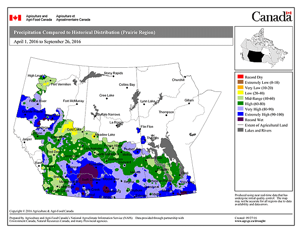
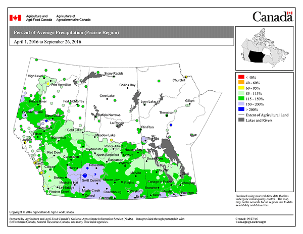
Thanks to the active weather, rainfall amounts were above normal throughout most of the three Prairie provinces. Only localized portions of northeastern Manitoba, central Saskatchewan and southwestern Alberta saw below normal rainfall. The wettest areas relative to normal were the southern Red River Valley in Manitoba, southwestern Saskatchewan and southeastern and northwestern Alberta. The following two maps from Canada Drought Watch show percent of normal precipitation and precipitation percentiles for the season since April.
Precipitation percentiles for April 1 to September 8, 2016
Percent of normal precipitation April 1 to September 8, 2016
The highest rainfall totals from April 1 to September 8 in southern Manitoba were along the US border in the Killarney to Sprague area where 500 to 750 mm of rain fell. A secondary area of heavier rainfall also occurred east and northeast of Winnipeg with 500 to 650 mm. Letellier took top honours with a whopping 752 mm at the Manitoba Agriculture station. 18 days saw over 20 mm of rain as rounds of heavy rainfall occurred almost every few days. Farmers regularly faced overland flooding on their fields as a result. Other high rainfall totals in the area included Green Ridge with 630 mm, Vita 563 mm, Altona 568 mm, Killarney 520 to 550 mm, Steinbach 530 mm and Morden 490 to 550 mm. High rainfall totals also fell in the Whiteshell area where heavy rains at times caused serious flooding. About 620 mm of rain fell in Falcon Lake and 572 mm in Hadashville during the period. All the above rainfall totals are via Manitoba Agriculture, Manitoba Fire and Cocorahs.
In Winnipeg, rainfall was slightly above average at the airport between April 1 and September 8 with 365 mm. Average for the period is close to 340 mm. Higher totals fell in other parts of the city however, with 420 to 470 mm in western and southern sections.
Year of Severe Thunderstorms and Tornadoes
A total of 16 tornadoes occurred in Manitoba this year; 1 in May, 2 in June, 5 in July and 8 in August. This is up from 11 tornadoes last year and the most tornadoes in a year in a couple of decades (the 1980’s to early 90’s was a busy period). Manitoba also had the most tornadoes in Canada this year. There were a number of multi-tornado-day events including 4 on August 8 and 3 on July 20 and August 3.
There were many notable hail and wind events this summer across southern Manitoba, too many to list. As a result, I have prepared a list below of what I believe were the top 5 events of the summer.
Top Thunderstorm Events
I have listed, in chronological order, what I believe were the top thunderstorm events of the summer in southern Manitoba
June 24/25 Derecho
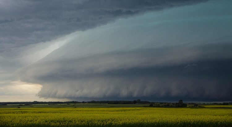
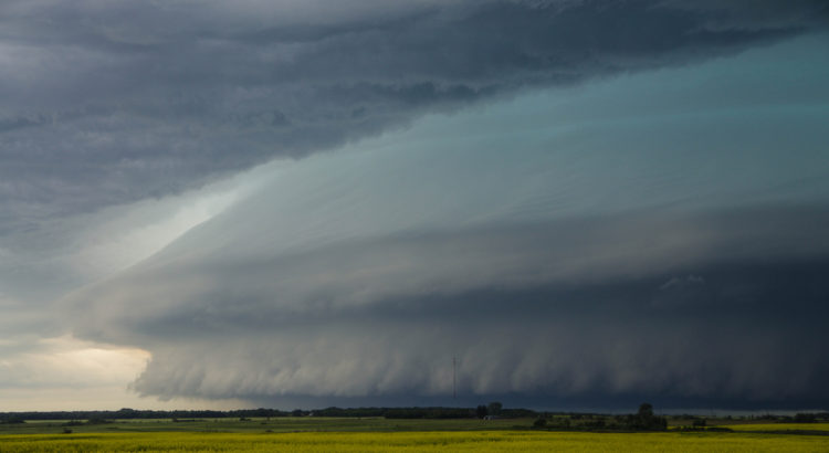
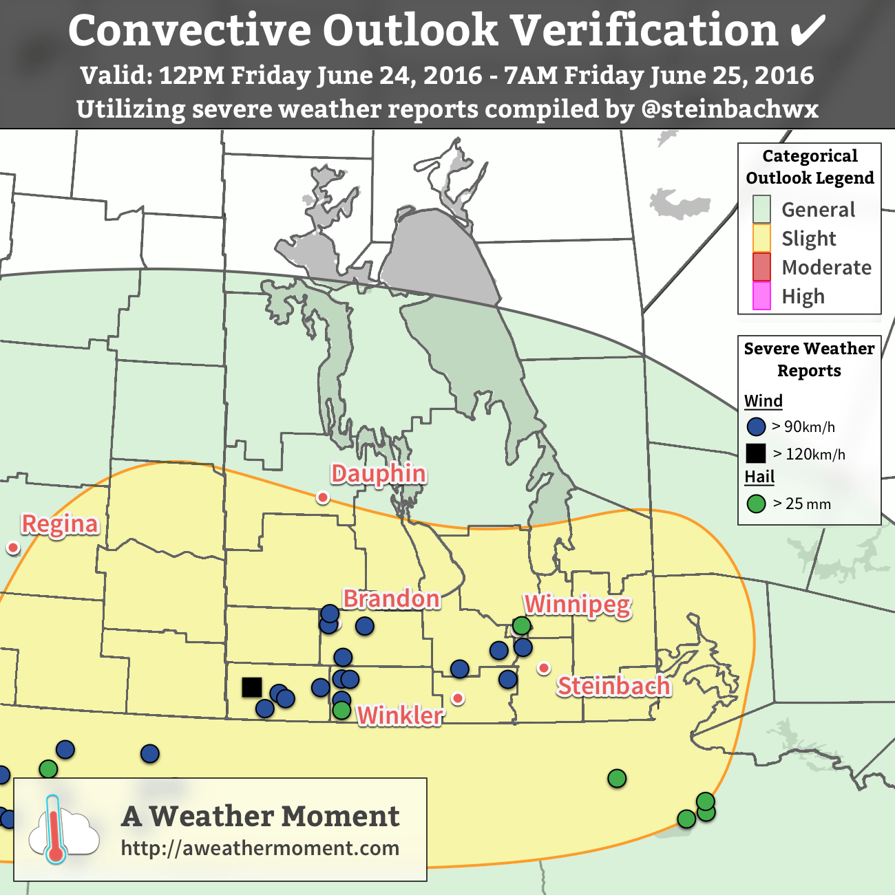
A rare derecho event occurred from the evening of June 24th into the overnight on June 25th. A severe thunderstorm complex moved in from Montana and raced across southern Manitoba. A derecho is one of the most intense thunderstorm events with respect to wind. By definition, it is a thunderstorm complex that produces winds of at least 50 knots (93km/h) along a swath at least 400 km long and whose life span exceeds 6 hours. In addition, no longer than 2-3 hours must pass between successive wind reports. These criteria were met during the June 24/25 event. The following map shows AWM`s Convective Outlook Verification for the event and is included here to show where the severe events were recorded.
Verification of the AWM Convective Outlook for Junes 24/25, 2016 with hail and wind reports overlaid. Additionally, flooding due to rainfall was reported in several locations within the slight risk region.
Winds in excess of 90 km/h occurred in a swath from Melita to Carberry to Carman to Saint Adolphe with the derecho. Melita was pummelled with a maximum recorded gust of 124 km/h! Trees, fences and homes suffered damage. Gusts over 100 km/h occurred in Deloraine (102 km/h), Waskada (107 km/h) and Carberry (102 km/h), and gusts over 90 km/h occurred in Killarney (96 km/h), Somerset (90 km/h), Ninette (90 km/h), Carman (93 km/h), Morris (91 km/h), Sanford (90 km/h) and Saint Adolphe (92 km/h). Damage was widespread and significant with snapped trees, crop damage and other property damage. Streets in some areas were littered with branches and debris the next morning.
A narrow jet (sting jet?) of winds between 90 and 110 km/h also occurred in the Brandon area behind the massive thunderstorm complex around 4 am. This was a very interesting occurrence because these winds occurred behind the storms and would be a great case study project. Brandon airport recorded a gust of 106 km/h with the event. Forrest, just north of Brandon, recorded a gust of 98 km/h. Trees were snapped and uprooted, which caught many by surprise because there was no thunder or lightning and only light sprinkles occurring at the time.
Mess in Carman with Twigs n branches everywhere and found this tree toppled. Trees snapped 10 km east #mbstormpic.twitter.com/hBHrLEg8Z0
Wind was not the only severe weather with the storms. Toonie sized hail occurred south of Killarney and nickel sized hail in Winnipeg. Flooding was a problem as well. 80 to 100 mm of rain fell in the Killarney area with a swath of 50 to 80 mm northeastward to Elm Creek. Winnipeg received 25 to 40 mm with highest amounts in southern and eastern sections. Estimated wind gusts near 80 km/h also occurred in the south end as the city was brushed by the strongest winds to the south. Another swath of 50 + mm fell from Selkirk southeastward to Falcon Lake. In fact, the Falcon Lake/West Hawk Lake area received an incredible 140 to 160 mm of rain. Flooding was severe with some highways underwater and closed. Lake levels in the area were unusually high.
July 20 Supercells / Long Plain Tornado
A series of severe thunderstorms developed in southwestern Manitoba and southeastern Saskatchewan after 4 pm and raced eastward through southern Manitoba in the evening.
The storms dropped up to tennis ball sized hail in extreme southeastern Saskatchewan before entering into Manitoba. In Manitoba, numerous funnel clouds were seen with the storms west and southwest of Brandon. Two of these became landspout tornadoes near Hartney. With no damage reported, these were rated EF-0. The main story initially was the hail with toonie to tennis ball sized hail from the Melita to Brandon areas. The City of Brandon was hit hard with hail up to golf ball sized, wind gusts over 80 km/h and up to 40 mm of rain in 1 hour.
The supercells then continued eastward with incredible wind gusts and a damaging tornado south of Portage la Prairie. A summary of wind gusts is provided in the following table:
Location
Maximum Wind Gust (km/h)
Portage Southport
138
Selkirk
115
Mountainside
110
Winnipeg Int'l Airport
107
Elm Creek
107
Starbuck
101
Gretna
96
Cartwright
95
Carberry
94
Deerwood
93
The area south of Portage was worst hit with winds over 130 km/h recorded. Widespread and significant damage occurred with trees toppled and uprooted and buildings damaged. A supercell tornado also occurred at the Long Plain FN and New Rosedale Hutterite Colony south of Portage. Buildings were shifted off their foundations, roofs ripped off homes, hydro poles toppled, cars flipped, sheds and farm buildings destroyed and trees were again toppled and uprooted by the tornado. Debris was scattered across fields downwind. The tornado was rated an EF-1. According to CBC, about 150 homes were damaged and some residents remain displaced in September. A video of the tornado from a distance exists here. A timelapse of the storm coming in Winnipeg exists here.
The storm then raced east toward the Winnipeg area. The storm was one of the most ominous storms ever seen with a massive shelf cloud, nearly-constant flashes of lightning and a sky that was almost completely green. Damaging winds occurred with a gust of 107 km/h at Winnipeg International Airport and 115 km/h in Selkirk. Significant damage occurred with trees toppled and some buildings damaged. A roof was partially ripped off an apartment building in north Winnipeg. An estimated 1 million dollars in damage also occurred to a U of M professor`s equipment at the St. Andrews airport. Wind damage also occurred in the Beausejour, Anola, Treherne, Elie and Elm Creek areas. According to Manitoba Hydro [CBC], at peak, 32,000 Manitobans were without power, about 20,000 of which were in Winnipeg.
August 3 Tornado Outbreak
A series of supercell thunderstorms developed in southwestern Manitoba and North Dakota in the afternoon and persisted through the evening. The storms produced numerous tornadoes with three tornadoes in Manitoba: at least one tornado near Glenboro, one tornado west of Morden and a landspout tornado near Margaret.
The town of Glenboro was lucky as a tornado narrowly missed the town. A tornado formed south of the town after 5 pm and the storm continued to produce a tornado for close to half an hour as it continued northeastward and crossed highway 2. The tornado at one point was a massive wedge tornado northeast of town. Farm sheds and buildings were damaged or destroyed, trees were uprooted and hydro poles were toppled by the tornado. Video of tornado exists here. The storm also dumped 57 mm of rain in 1 hour in Glenboro and 54 mm in 1 hour in Holland to the east. Peak rainfall was just north of Glenboro with a 79 mm storm total recorded at a Weather Farm station.
The Morden area was hit hard by storms moving up from North Dakota. A wind gust of 111 km/h was recorded at the airport. Streets in the city were littered with twigs, branches and toppled trees and shingles were ripped from roofs. Streets were also flooded after 30 to 50 mm of rain fell. A tornado was also seen west of the city in pictures, but no damage directly related to the tornado was ever reported.
Wind damage also occurred in Portage la Prairie, Plum Coulee and Gretna thanks to wind gusts between 80 and 95 km/h.
Storms danced around Winnipeg during this event with only a few mm of rain recorded. Lightning was spectacular however. The storms had just scraped the south end. Saint Adolphe, a short drive south of Winnipeg, recorded 54 mm of rain in 1 hour and a wind gust of 92 km/h. Branches were taken down and some minor flooding was reported.
The low pressure system responsible for the thunderstorms on August 3 also produce slow-moving thunderstorms in the wrap-around portion of the system north of Dauphin. 150 to 190 mm of rain fell in the Ethelbert area in just 6 hours. Flooded fields were reported.
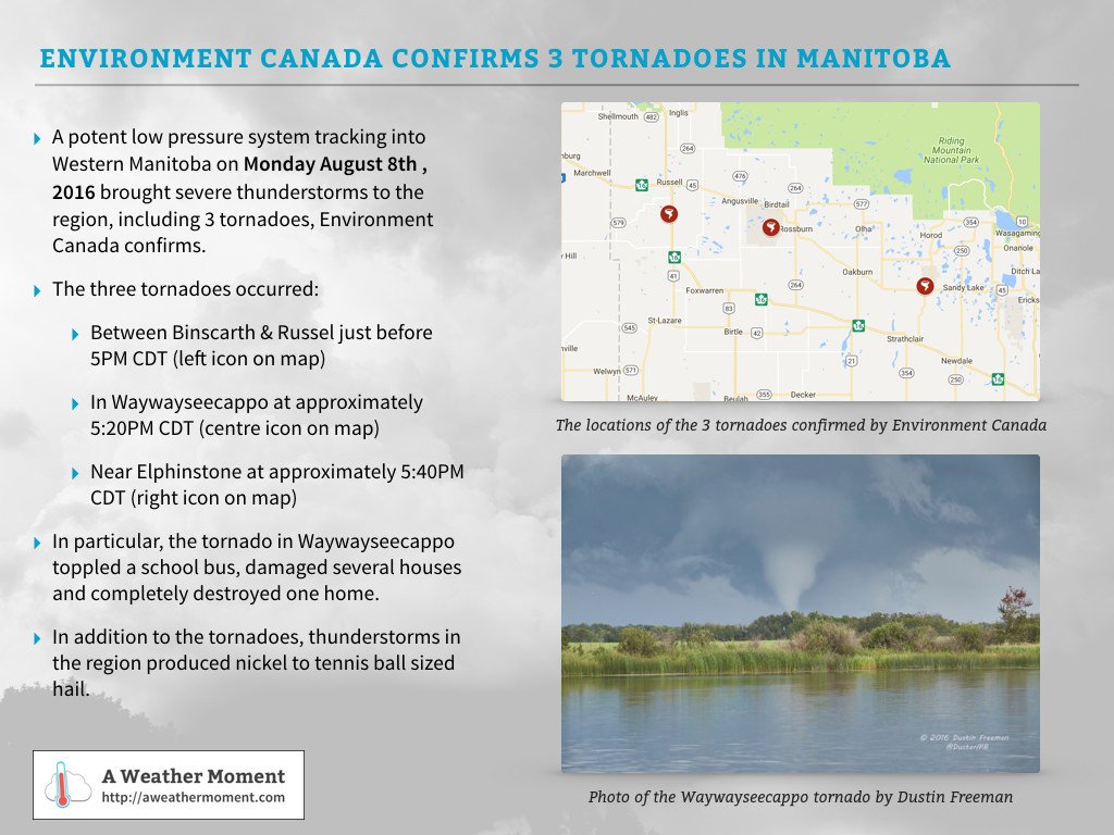
August 8 Tornado Outbreak
Supercell thunderstorms developed in Saskatchewan and moved into southern Manitoba southwest of Riding Mountain National Park, producing the largest tornado outbreak of the year in terms of number of tornadoes. Four tornadoes were confirmed, two of which were rated EF-2 and two rated EF-0. The storms, which tracked from Russell to Erickson, also dumped hail up to tennis ball sized.
Waywayseecappo FN was hit by one of the EF-2 tornadoes. Several homes were damaged or completely destroyed. A school bus was also flipped on its side. Hail up to golf ball sized also fell with the storm. Some residents were evacuated after the storm.
A summary card produced by AWM for the August 8, 2016 tornado outbreak.
The other tornadoes were south of Russell, near Elphinstone and near Erickson. The one south of Russell was rated an EF-0 based on tree damage. The one near Elphinstone was also given an EF-0 rating due to no reports of damage. The tornado near Erickson was rated an EF-2. A long swath of forest about 500 metres wide was completely flattened (seen thanks to aerial photos from CBC) and bark ripped off trees. Swirls could be seen in the forest from above, confirming that a tornado indeed produced the damage. The tornado also damaged homes and other buildings in the area. The storms continued southeastward after the last tornado, but weakened.
High Humidity
With an average dewpoint temperature of 13.7°C, summer 2016 tied with 2005 for third most humid summer since 1953 in Winnipeg. Some might think this stat is a little surprising because the summer really wasn’t that hot. In fact, temperatures were only near normal overall and very hot days were few and far between. This was probably a good thing because otherwise, the high humidity combined with hotter temperatures would have made the summer much more unbearable.
July 20 saw the peak humidity of the summer when dewpoint temperatures rose to the 24 to 27°C range across southern Manitoba, breaking records. At Winnipeg Int’l Airport, dewpoint peaked at 25.9°C, the second highest dewpoint reading on record since 1953. The record is 26.1°C on July 17, 1966. Dewpoint temperatures reached an amazing 27°C in Carman, Winkler, Portage, Altona, Beausejour and Minnedosa. The highest reading was in Carman at 27.4°C. The heat and humidity together produced humidex values in the mid 40`s.
Hottest Day of the Year Was Outside of the Summer Season
Consistent with few very hot days this summer, the hottest day of the year was actually outside of the summer season. A high of 35.2°C on May 5th was the hottest of the year and the earliest date to reach the highest temperature of the year on record since 1872. It was also only the 12th time that our hottest day of the year was in May. The high of 35.2°C was also the earliest occurrence of temperature over 35.0°C on record since 1872. Previous earliest was May 8, 1874 with a high of 35.0°C.
Rank
Date
High
1
May 5, 2015
35.2°C
2
May 7, 1891
34.4°C
3 (tie)
May 13, 1932
33.3°C
3 (tie)
May 13, 1977
32.6°C
5 (tie)
May 19, 1948
35.0°C
5 (tie)
May 19, 1992
34.2°C
Warm Year and September so Far
The January to August period averaged 5.5°C in Winnipeg, tied with 1999 for 13th warmest on record since 1873. September so far is averaging just over 2 degrees above normal, making this the 14th warmer than normal September in the last 16 years. September has been and seems to continue to be warming at a rapid pace. In fact, September has warmed 1.0°C in the last 20 years, 0.7°C in the last 10 years and 0.5°C in the last 5 years, showing that warming for the month has accelerated in recent years. The 30-year 1987 to 2016 average for September is 13.4°C, up from 12.9°C in the 1981-2010 normal and the warmest Septembers have been on record. There is certainly no guarantee that this warming trend will continue forever, but what is interesting is how rapidly the month has warmed and how rare it has become to experience a chilly September.
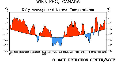
Winter 2015-2016 brought just what was predicted to southern Manitoba: much warmer than normal conditions, a shorter winter and a lack of major snowstorms overall (except the week before Christmas).
Daily temperature departures from normal from December to February in Winnipeg, via NOAA
One of the Strongest El Ninos on Record
Whether or not this past winter featured the strongest El Nino on record has not been confirmed yet. There are many indices that measure the strength of El Nino and their values are still preliminary. Nonetheless, the Oceanic Nino Index (ONI) is one of the primary indices. It measures the 3-month average sea surface temperature departure from normal in the Nino 3.4 region (the central Equatorial Pacific Ocean). The ONI peaked at 2.3 in the November to January period, tied with the winter of 1997-1998 for highest on record since records began in 1950. Without a doubt, this past winter joined the winters of 1982-1983 and 1997-1998 for the top three strongest El Ninos since 1950.
Category
Total/Average
Deviation From Normal
Rank (Since 1872)
High Temperature
-7.1°C
+ 2.4°C
13th warmest (tie)
Mean Temperature
-11.3°C
+ 3.2°C
9th warmest
Low Temperature
-15.4°C
+4.0°C
7th warmest (tie)
Rainfall
0.4 mm (est.)
- 4.2 mm
69th rainiest (tie)
Snowfall
85.0 cm
+ 23.1 cm
24th snowiest
Precipitation
53.1 mm (est.)
- 1.2 mm
60th driest
A Top 10 Warmest Winter With a Lack of Cold Days
With an average mean temperature of -11.3°C in Winnipeg, winter 2015-2016 was the 9th warmest winter on record since 1872.
Top 10 Warmest Meteorological Winters (Dec-Jan-Feb) in Winnipeg Since 1872
Rank
Mean Temperature
Year(s)
1
-7.2°C
1877-78
2
-8.2°C
1997-98
3
-9.5°C
1986-87
4
-9.7°C
2011-12
5
-10.1°C
1930-31
6
-10.8°C
1991-92, 2005-06
8
-10.9°C
1982-83
9
-11.3°C
2015-16
10
-11.6°C
1999-00
There was a notable lack of cold days from December to February with just 30 days dipping below -20°C. This was well below the 1981-2010 normal of 46 days and tied with the winter of 1918-19 for 8th least -20°C days since 1872. In addition, only 1 day dipped below -30°C, the third least -30°C days on record since 1872. The winters of 1930-1931 and 2011-2012 were the only ones to not see one day below -30°C and this winter was the only one to see just 1 day below -30°C. The 1981-2010 normal is 13 days below -30°C.
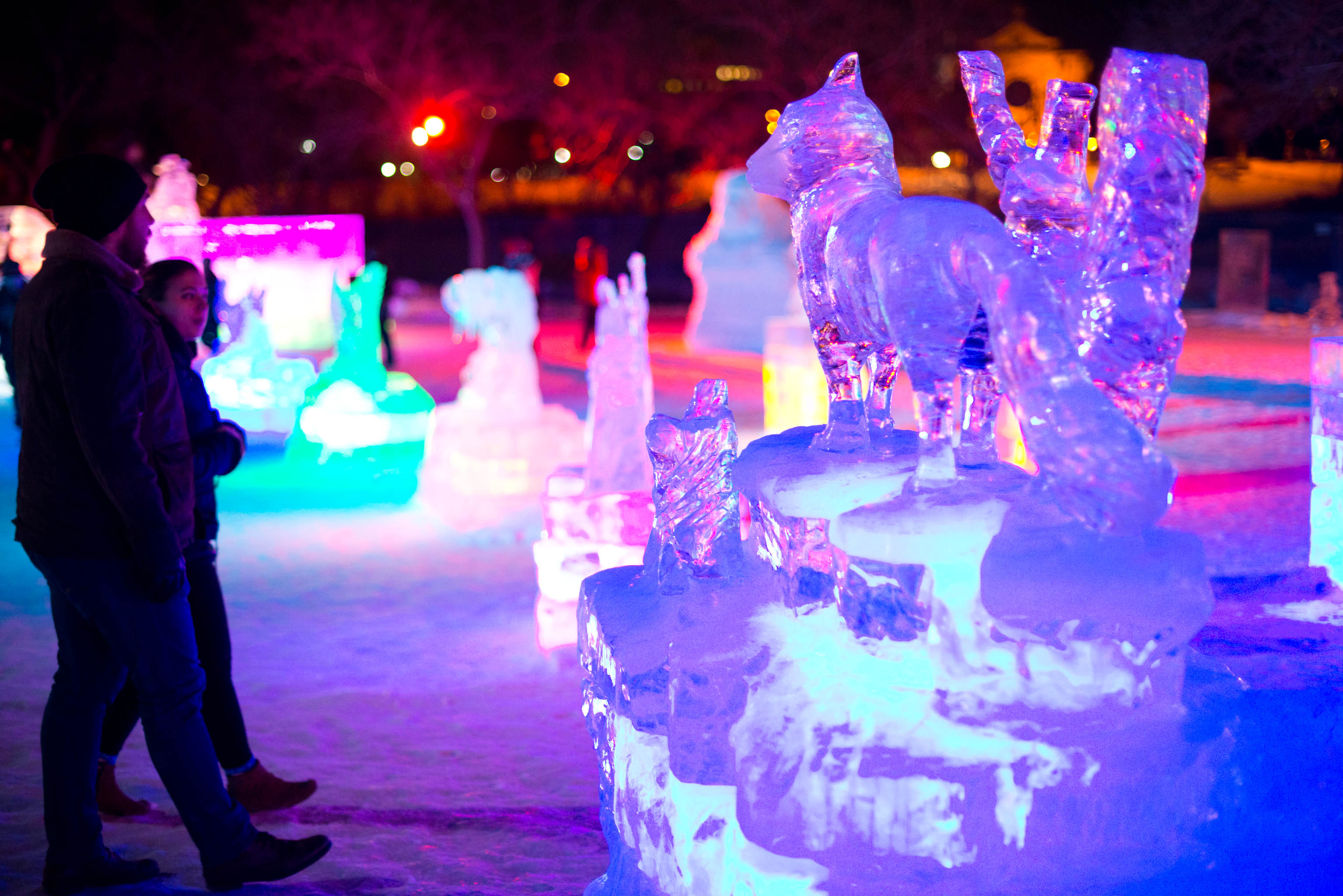
Despite warmth, it was still cold and snowy enough for Winnipeg’s winter festivals. The Ice Show, shown here, was a new addition this winter. Credit: ManitobaHot.com
Winter’s Late Arrival
A significant warm spell occurred in the first half of December, delaying the arrival of sustained winter conditions until mid December. In fact, it was the second warmest first half of December on record since 1872 in Winnipeg with an average mean temperature of -3.0°C. 14-consecutive days from the 3rd to 16th never dropped below -9°C and 8-10 days exceeded freezing. The only record broken during the warm spell was on December 9 when a high of 5.6°C at the airport broke the old record of 5.1°C in 1990. No snow was on the ground in parts of southwestern Manitoba and in the Morden-Winkler area allowing temperatures to reach double digits. In Morden, four days exceeded 10°C, three of which were record highs. The high of 14.2°C on December 4 was the third warmest on record in December since 1904. Some thermometers reportedly reached 15°C, more typical of late September or early October. A similar milestone was reached in Brandon with a high of 11.1°C on the 4th, the third warmest temperature in December since 1890.
In the end, it was the 9th warmest December since 1872 in Winnipeg with an average mean temperature of -8.1°C.
Stormiest Part of Winter
Winter, once it finally arrived, came in with a bang on December 16 thanks to a major Colorado Low. About 20 cm fell in Winnipeg, 18 cm of which fell on December 16 alone breaking the old record of 8.4 cm in 1942 for the day. Two additional snowstorms before Christmas dumped another 20 cm. Thanks to the snowfall, snow depth in Winnipeg sat at 30 cm on Christmas morning, the deepest snow pack on Christmas Day in 15 years (since a 30 cm depth in 2000). In total, 44.0 cm of snow fell in Winnipeg in December, 83% above normal and the 12th snowiest December on record since 1872.
January and February – Mild With Just Two Brief Cold Spells
The worst cold spell of the winter was in early to mid January from the 9th to the 19th. 5 days never rose above -20°C. The coldest night of the winter was on the 17th with a low of -32.3°C, the only -30°C day of the winter. Another brief cold spell occurred from February 8th to 13th, but was not very significant. The coldest temperature was only -27.9°C. Other than that, conditions were near to above normal, making for an easy mid-winter. It was warmest in late January and late February with a combined 8 days above freezing in Winnipeg. The late January warm spell in particular was sufficient to erode much of the snowpack in southwestern Manitoba thanks to warm temperatures and rainfall. Fields were nearly bare from Morden to Melita. Without much snow in February, these areas maintained a very thin to non-existent snowpack up until March. This allowed for warmer temperatures with highs reaching 9°C in Melita in early and late February.
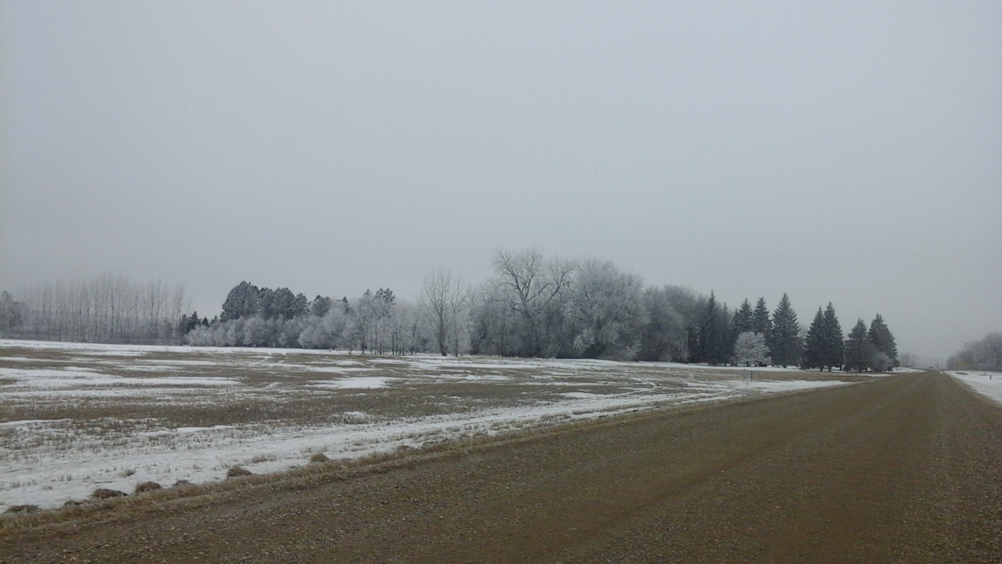
Hoar frost and lack of snow south of Winkler February 1, 2016
In the end, January averaged -14.6°C in Winnipeg, 1.8°C above normal and tied 29th warmest since 1872. February averaged -11.1°C, 2.4°C above normal and tied 22nd warmest since 1873. This was only the second warmer than normal February since 2005.
February Thundersnow
Even some thundersnow occurred not far from the US border in late February, an extremely rare event in this area. One lightning strike was recorded northeast of Altona just after midnight on February 23. Even stronger thundersnow occurred just south of the border near Langdon, ND in the evening on February 28.
Remarkably Warm February Out West
The further west you went in the Prairies, the warmer it was in February. Cold snaps generally remained to the northeast and there was little to no snow on the ground from Melita, MB westward to Calgary, AB. Persistent warmth was the story in this area, especially in southern Alberta. After February 3rd, every single day exceeded the freezing mark in Calgary and this streak has continued into March. In addition, 7 days in February reached double digits with a monthly high of 16.9°C on February 26. There was also a lack of snow with not a single snowfall from February 2nd to 27th. With just 1.8 cm, it was the 5th least snowy February since 1885 in Calgary. Lethbridge, AB was even warmer in February with 15 days reaching double digits. Saskatchewan also received this extreme warmth. Only 11 days failed to exceed the freezing mark in Regina. The monthly high was 13.2°C on February 26, the second warmest temperature on record in February since 1884.
From east to west, here’s how February averaged and ranked across the southern Prairies:
City
Average
Deviation From Normal
Rank
Winnipeg, MB
-11.1°C
+ 2.4°C
22nd warmest (tied)
Brandon, MB
-9.3°C
+ 4.3°C
7th warmest
Regina, SK
-4.5°C
+ 7.6°C
4th warmest
Calgary, AB
1.4°C
+ 6.8°C
2nd warmest
North Dakota Record February Warmth
The warmth was also extreme to our south in North Dakota. Bismarck, located in southwestern North Dakota, reached a record 23°C on February 27. This was the warmest temperature ever recorded in North Dakota in February, breaking the old record of 22°C in 1992.