A developing low pressure system in North Dakota will generate a widespread thunderstorm threat this evening and overnight that extends into southern Manitoba.
In North Dakota, there’s very high confidence that there will be some truly dangerous thunderstorms later today. A confluence of all severe weather parameters – extremely high amounts of energy, favourable wind profiles with high amounts of shear, a clear and potent focus for thunderstorm development – has led the SPC in the United States to issue a “moderate risk” thunderstorm hazard for the state today. Further north, things become a little more unclear and conditional in southern Manitoba.
The overall synoptic setup is summarized succinctly in the PASPC’s daily significant weather discussion:
[…] approaching long wave upper trough creating favourable synoptic setup tonight/overnight for a developing Colorado Low convective complex. This begins as a rapidly deepening baroclinic surface low in the Northern States with associated associated severe surface-based convection beginning this afternoon or evening.
So a rapidly deepening Colorado Low-type system will develop severe thunderstorms over North Dakota this afternoon. Continuing:
[As the convection] evolves and severe elevated convection becomes dominant through the night. Big question is where does [it] go? Details vary widely amongst model solutions, with some bringing severe convection clipping SE Saskatchewan then moving through southern Manitoba, and others confining the bulk of the severe weather to the United States.
And that is the big question. Where will the thunderstorms develop tonight? Here’s our thoughts, omitting much talk about what will happen in North Dakota.
The primary focus for thunderstorm development tonight in southern Manitoba will be split between two features. The first will be a warm front draped west to east along the Canada/US border for much of the night before lifting a bit further north over southeastern Manitoba late overnight. The second will be a mid-level shortwave that moves across southern Manitoba late overnight into Friday morning.
These two features will support independent areas of thunderstorm activity, then merge into a single area as the shortwave moves over the warm front.
There are two primary ways this could play out; we’ll cover the most likely way and then cover Plan B©.
Most Likely Situation
A few isolated showers or non-severe thunderstorms are possible along and north of the warm front late this afternoon across northern North Dakota and far southern Manitoba. A more organized area of thunderstorms will develop over western North Dakota this evening and become the focus for thunderstorm activity for the following 12 hours. The thunderstorms will develop into a QLCS – quasi-linear convective system – mid-evening and accelerate eastwards. The mid-level shortwave moving into the region will draw moisture northwards from the QLCS across the border into southern Manitoba, supporting an area of showers and thunderstorms into southern Manitoba.
This activity will develop over the southwestern corner of the province sometime between 9 and 11 PM, then spread into the Red River Valley overnight.
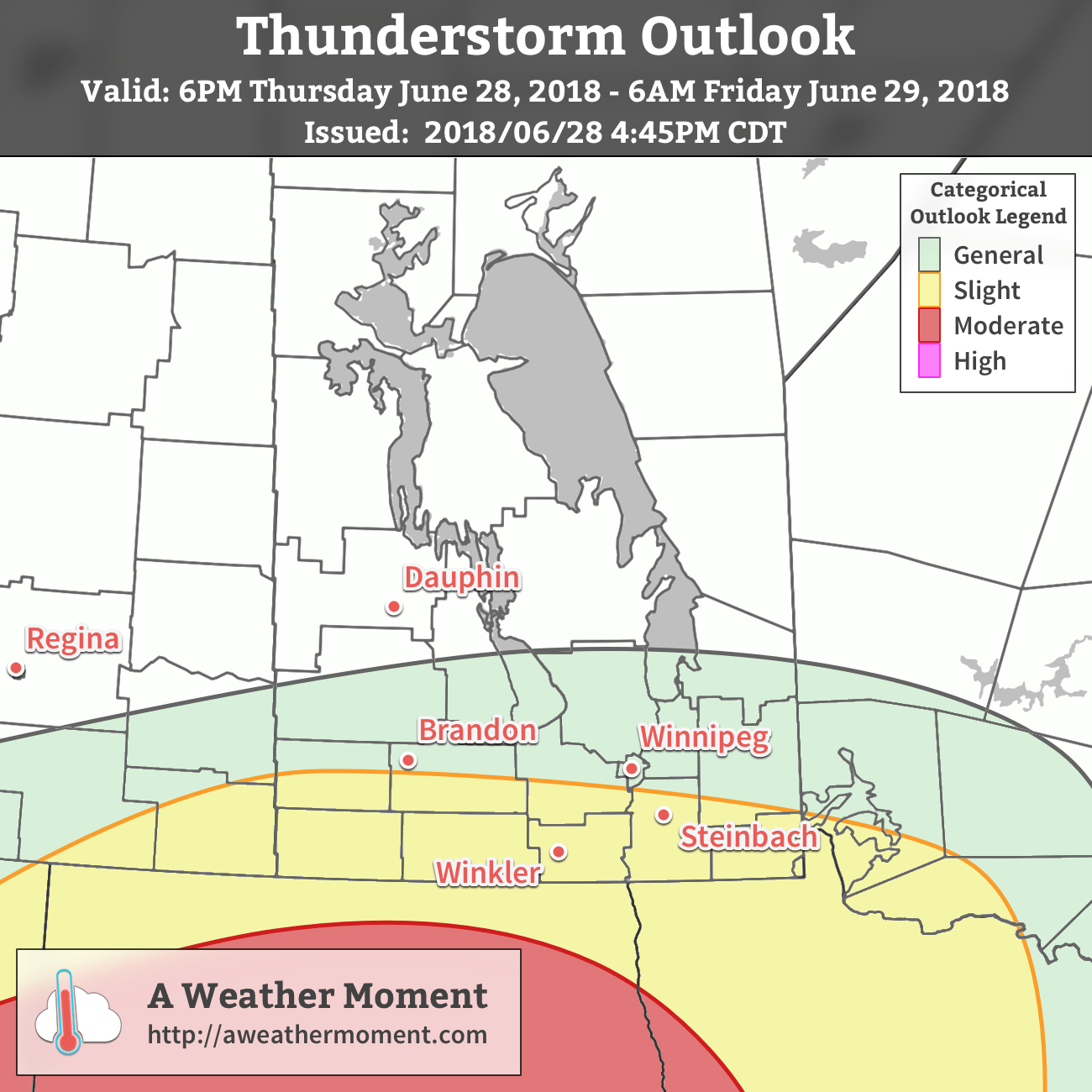
Much of the severe weather in this scenario will be confined to North Dakota. There would be a slight risk of a severe thunderstorm south of the Trans-Canada Highway in Manitoba with primary threats of overland flooding due to heavy rainfall and large hail.
The convection will clear out overnight or early Friday.
Plan B
The alternative solution is one where the QLCS developing in North Dakota ends up surging eastwards, breaking away from the mid-level shortwave and becoming its own entity as it races towards Minnesota. In this case, less thunderstorm activity would be seen around the mid-level shortwave as it pushes into Manitoba overnight, however the organized southerly flow riding over the warm front would be undisturbed, likely allowing elevated thunderstorms to fire up overnight across far southern Manitoba. These thunderstorms, were they to form, would be more scattered in nature, but would pose a marked hail threat alongside torrential rains.
Not As Bad As It Looked Just 12 Hours Ago
In the end, the situation doesn’t look quite as bad over Manitoba as it did earlier this morning. If our expected solution pans out, most areas should just see a decent soaking with 15 to 30 mm of rain. Localized higher amounts will be possible, particularly closer to the US border. If the hail stays away, then we could be getting up tomorrow in the wake of a much-needed rainfall.
That said, if Plan B is what happens, or a hybrid of our expected solution and Plan B, then residents will need to prepare for the potential for large hail and localized flooding. We’ll be keeping an eye on things and likely issue one last brief update on our social media accounts later this evening.