The Sun Makes A Return

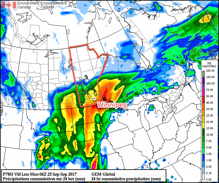
After a streak of cloudy and wet weather which brought the most significant multi-day rainfall totals of 2017 to Winnipeg, the sun is finally set to return. Winnipeg will enjoy several relatively sunny days ahead with temperatures rebounding back towards seasonal values.

After seeing 65.1 mm of rain in the past 10 days, Winnipeg is poised to enjoy a few days to finish drying out1 as fairly benign weather returns to the region. Today will be quite a pleasant day; skies will start off sunny this morning and become more mixed in the afternoon with temperatures climbing to an above-seasonal high near 18°C. Winds will be light until a weak cold front passes through this afternoon, after which they’ll switch to the northwest at around 20-30 km/h for a few hours before diminishing near sunset. Skies will remain partly cloudy to mixed overnight with temperatures dipping to a low near 7°C.

RDPS 2m Temperature Forecast valid 21Z Wednesday September 27, 2017
Temperatures will climb into the upper teens this afternoon across southern Manitoba

Thursday’s main driver for the weather will be a large ridge of high pressure building southwards out of the Arctic. As it pushes towards the southern Manitoba, it will keep winds out of the north at 20-30 km/h with slightly cooler temperatures in place as highs climb to a seasonal 16°C. Skies will remain partly cloudy much of the day. Thursday night will be a cool one as the high pressure centre moves across Southern Manitoba. Temperatures will dip to a low near 2°C with patchy frost an outside chance, but it looks relatively likely (for now) that extensive fog development may occur through the night, which would likely keep lows above the freezing mark. That said, it’ll certainly be cool, so if you have temperature-sensitive plans, probably best to take care of them before Thursday night.

GDPS 2m Temperature Forecast valid 12Z Friday September 29, 2017
The GDPS suggests a patchy freeze will be possible on Friday morning

Friday will bring mainly sunny skies to Winnipeg & the Red River Valley, outside of any fog that may be in the region in the morning. As the high pressure system moves off to the southeast, it will bring southerly winds at around 10-20 km/h as temperatures climb to a high near 16°C again. Temperatures will dip to a low near 8°C on Friday night with winds increasing out of the south to 20-30 km/h.

Long Range

Warmer, but windy, weather will move into the Red River Valley on Saturday with daytime highs climbing towards the 20°C mark as an upper ridge pushes into the eastern Prairies. Conditions begin turning on Sunday as another significant low pressure system moves towards the region. During the day on Sunday will likely be mild, although cloudy, with breezy southeasterly winds. At some point, there will be a more organized chance for rain; likely on Sunday night into Monday morning, but it could easily shift by 12 hours between now and then.

The work week will start off with seasonal temperatures and some lingering unsettled weather until things clear up mid-week again.

Winnipeg’s seasonal daytime high is currently 15°C while the seasonal overnight low is 4°C.

  1. And perhaps letting the grass grow long enough to need to be cut again…

Cool, Soggy Weather Slow to Leave

Although Winnipeg has seen most of the rain the city will receive during this unsettled period, the cool and soggy weather will remain in place for a couple days yet before improving for the latter half of the week.

Skies will remain mostly cloudy1 across the central and eastern Red River Valley today ahead of yet another disturbance that will lift northwards through the American Plains towards southern Manitoba. Under the cloud, there will be a continued chance for drizzle, particularly through the morning hours. The areas that may even see very heavy drizzle or showers will be south of Lake Winnipeg, where the warm lake waters will enhance the intensity of the precipitation. Temperatures will continue cool today with highs near 12°C with winds out of the north at 15-25 km/h. Skies will remain cloudy tonight with a continued chance for drizzle. Temperatures will drop to a low near 7°C while winds diminish to light.

Winnipeg NAM Forecast Sounding valid 12Z Monday September 25, 2017
Deep low-level moisture will help to sustain periods of drizzle until midday Monday.

Tuesday will bring more rain to southeastern Manitoba as another disturbance moves through Minnesota. While the rain moves through the southeastern corner of the province, portions of the Red River Valley will see a chance of rain, mainly due to uncertainty about how far west the rain will actually reach. Winds will remain light as temperatures head to a high near 12°C once again.

The rain will taper off by evening as the light winds shift to the west and temperatures drop to a low near 6°C. Skies will clear overnight.

Some models are keeping much of the rain east of the Red River Valley, while others pull westwards.

Wednesday will finally bring sunny conditions back to the region with clear skies in the morning giving way to partly cloudy skies in the afternoon. Temperatures will be quite a bit warmer with highs near 19 or 20°C and westerly winds of 10-20 km/h.

Temperatures will once again drop to a low near 6°C on Wednesday night with skies clouding up again. An upper-level disturbance will swing across the Red River Valley from west to east overnight, likely bringing another batch of rain to the region with 5-10 mm possible, although amounts will likely taper off quickly to the south of the line, likely leaving portions of the southern valley with no rain.

Long Range

The latter half of the week looks to return to more seasonal temperatures as northwesterly winds move back into the region behind Wednesday night’s disturbance and a large ridge of high pressure moves in. There may end up being a significant frost risk at some point later in the week, but we’ll have to just wait and see how cool things are able to get underneath the ridge of high pressure.

There’s some indication that more unsettled conditions will move back into the region on weekend or early next week as another upper-level trough digs over the American Rockies.

Winnipeg’s seasonal daytime high is currently 16°C while the seasonal overnight low is 4°C.

  1. Some sunshine will likely work into the western Red River Valley; if it manages to push further east, Winnipeg may end up seeing a bit more sun.

Late-Season Thunderstorm Risk Returns to the Red River Valley

A developing Colorado Low has brought very humid conditions to Manitoba’s doorstep, and a disturbance moving through the province today will tap into that moisture and spread showers and thunderstorms across the Red River Valley into the southeastern corner of the Province.

An upper-level disturbance moving through the province will bring a late-season thunderstorm risk to the Red River Valley with a small risk of severe storms. There’s a surprising amount of support for thunderstorms, largely due to the building humidity in Minnesota over the past few days. While the weather in Winnipeg is cool and dry, conditions have become positively balmy in Minnesota, where there are overnight lows in the 20s thanks to sticky dew points in the 20-22°C range.

A stationary front lies across northern Minnesota and far southeastern Manitoba this morning.

The dry air over the Red River Valley is separated from the muggy Minnesota conditions by a fairly strong frontal boundary running from Nebraska northeastwards through Minnesota and into northwestern Ontario. As an upper-level disturbance approaches today, that humid air will be lifted up over the front and into southern Manitoba. So while we won’t see particularly humid conditions here at ground-level, further up in the atmosphere will see significant moisture move in.

Before the weather gets busier this afternoon, temperatures will climb to a high near 18°C, but winds will be breezy, increasing out of the northeast to 30 gusting to 50 km/h.

By mid- to late-afternoon, things will likely begin firing up with widespread showers moving into the province from North Dakota. While showers and/or thunderstorms will be widespread over south-central and southeastern Manitoba, the severe thunderstorm threat will be confined to two regions. Within the Red River Valley, there will be a slight chance of an isolated severe thunderstorm or two, while southeastern Manitoba sees a higher chance of more widespread severe thunderstorm activity. The primary threats from today’s thunderstorms would be severe hail and/or wind.1

AWM Thunderstorm Outlook for September 22, 2017

The rain and thunderstorms will move out of the region this evening. When all is said and done, most areas will have seen somewhere between 5-10 mm of rain, with amounts of 20-40 mm possible in areas that see more thunderstorm activity. Skies will remain fairly cloudy tonight as temperatures dip to a low near 10°C with winds diminishing to around 20 km/h.

Things calm down for Saturday as the region sees a lull between Friday’s disturbance and another system moving on for Sunday. Expect mostly cloudy skies, a high near 16°C, and winds out of the north at around 20 km/h. Skies will remain cloudy on Saturday night with a low near 10°C again.

GDPS 24hr. QPF valid 06Z Monday September 25, 2017
Some guidance suggests significant rainfall on Sunday

A Colorado Low will progress through the region on Sunday, bringing rainy conditions to much of Southern Manitoba. Unfortunately at this time, it’s not quite clear exactly how rainy things will be. Some guidance has this system a bit more progressive and tracking further eastwards, which would result in 5-15 mm of rain in the Red River Valley, but others — such as the GDPS shown above — are slower with the system and bring it further west. The slower solutions would result in higher rainfall amounts for the region, more likely in the 15-30 mm range with localized spots perhaps seeing 40 mm.

At this point, the lower rainfall solution seems most likely, but we’ll be keeping an eye on it. Otherwise, it will be a cool day with a high of just 12°C and more northerly winds around 30 km/h. Expect a cloudy low near 9°C on Sunday night.

Long Range

Cloudy and cool conditions are expected to persist into the beginning of next week, but Winnipeg will likely be done with any significant rainfall chances. By mid-week, it looks like things will clear out with temperatures returning to seasonal values. The more pleasant weather may continue through next weekend, which would be a nice change!

Winnipeg’s seasonal daytime high is currently 16°C while the seasonal overnight low is 4°C.

  1. EC³ considers hail with 20 mm diameter or larger and wind gusts in excess of 90 km/h to be severe.

August Brought Mild Days, Cool Nights, and Almost No Rain

August was an interesting month regarding temperatures, particularly because the overall trend was shaped largely by the distinct lack of humidity. The monthly mean temperature ended up slightly below seasonal, but that was driven by unseasonably cool overnight lows. In fact, the average overnight low for August 2017 was 2°C below the seasonal average. Contrast that with daytime highs that were actually warmer than normal; August 2017 ended with an average high slightly above the seasonal average.

Perhaps of note, humidity levels were quite low through the month of August. We don’t quite have the dew point climatology set up here at A Weather Moment, so I asked Winnipeg’s resident weather statistician how August 2017 ranked in terms of average dew point:

So August 2017 ended up the 16th least humid of the last 64 years. The reason cooler nights can be linked to the low levels of humidity come from a simple physics lesson many learn in high school: dry air heats up – and conversely cools down – more quickly than water. The drier conditions allowed temperatures to climb high, but also allowed it to cool off more significantly at night.1 As an aside, this is why many humid places have smaller temperature ranges from day to night, while the driest places on earth typically have huge temperature ranges between day and night.

Getting into the actual statistics, August 2017 ended with a mean temperatures of 17.7°C, -0.8°C below the seasonal average of 18.5°C. The average daytime high was 25.5°C, 0.5°C above the seasonal average of 25.0°C. The average overnight low ended up at 9.9°C, -2.0°C below the seasonal average of 11.9°C.

August wraps up Summer 20172, which ended up with a mean temperature of 17.8°C. That places it as the 87th warmest3 on record, and comes in -0.6°C cooler than the summer of 2016.

Rain, What Rain?

Another notable aspect of August 2017 was the distinct lack of rainfall. Typically Winnipeg will receive around 77 mm of rain through August, but this year the city received only 14.1 mm at the airport, a mere 18% of the normal monthly rainfall.

August was just another month in the story of summer 2017: it was dry. The summer season accumulated 136.7 mm of rain at the airport, which was just 56% of the seasonal normal of 244 mm.

2017 Annual Precipitation Statistics – Updated September 20, 2017
Winnipeg is currently experiencing one of the driest years since 1981.

The drier pattern began in May, and then has not relented. While other areas in the Red River Valley are not quite in as dry a spell as Winnipeg, a general trend of dryness has persisted across much of the region.

August 2017 had measurable precipitation on just 6 of 30 days, with the single largest one-day rainfall total of 6.7 mm on Wednesday August 9th.


August 2017 was actually quite a pleasant month in many ways: most days brought a pleasant and dry summer warmth while evenings were cool. The month brought plenty of sunshine with rain being an elusive sight, continuing the dry trend that began in May of this year.

September has been quite a different month so far, with significant warmth in place this month. Winnipeg hit the warmest day of 2017 on September 12th when temperatures climbed to a record-setting high of 34.8°C. Daytime highs and overnight lows have largely been above-normal much of the month. While rain was sparse at the beginning of the month, the latter half has so far shifted into a more unsettled pattern, bringing relatively frequent rainfalls to the region, although Winnipeg has managed to elude much of the activity.

  1. I also asked Julien to calculate the correlation between humidity levels and highs and lows. Daily low temperatures had an r value of 0.61, showing a much stronger correlation than daytime highs which had an r value of 0.28.
  2. Meteorological summer runs through June, July, and August.
  3. …or 59th coldest, depending how you prefer to look at it.