Summer-Like Weather Finally Arrives in Winnipeg

The remainder of the work week will feature plenty of sunshine and a stark break from the cooler temperatures of late as daytime highs climb into the mid- to upper-20’s.

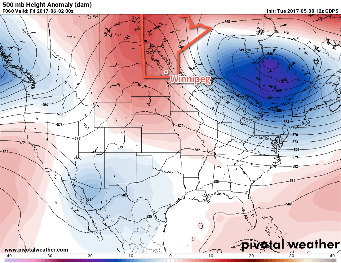
The next few days will bring dry, warm conditions to Winnipeg & the Red River Valley courtesy an upper-level ridge building eastwards across the Prairies. This weather feature will keep the clouds away and push daytime highs above-seasonal values as warmer air is drawn northwards out of the United States.

An upper-level ridge will be building into the Prairies today and tomorrow.

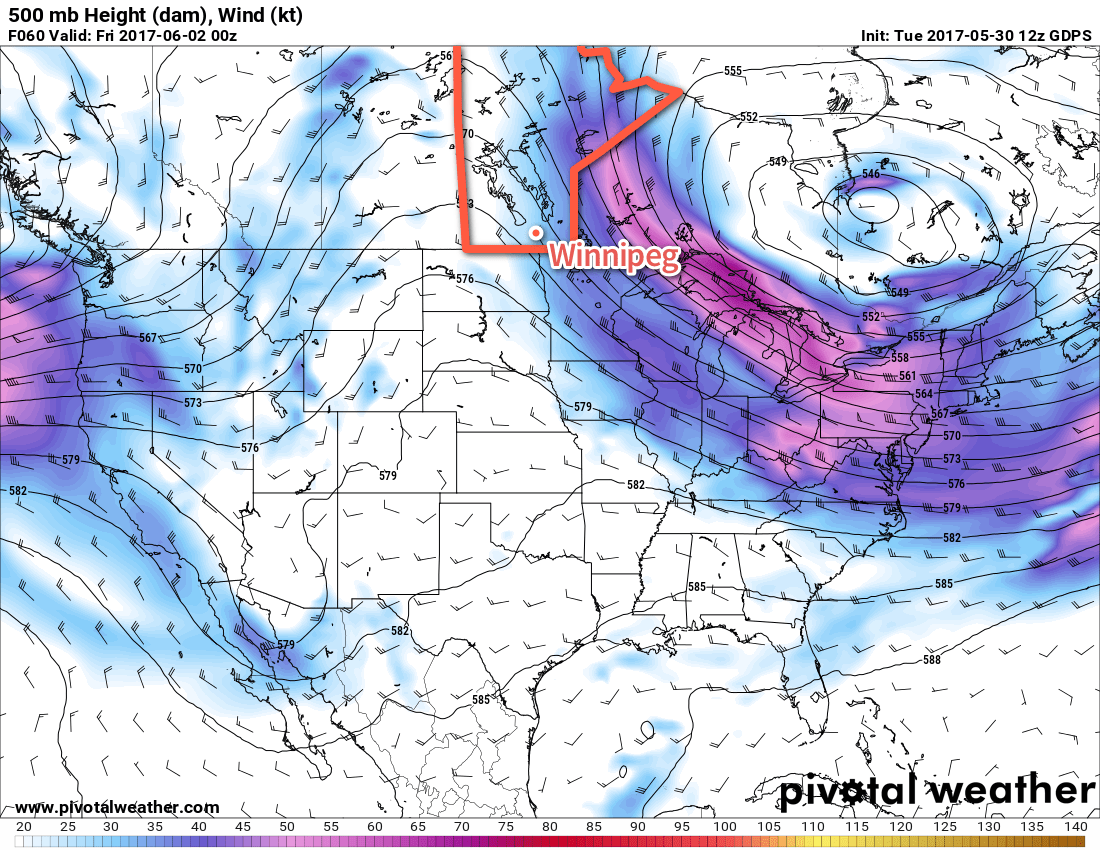
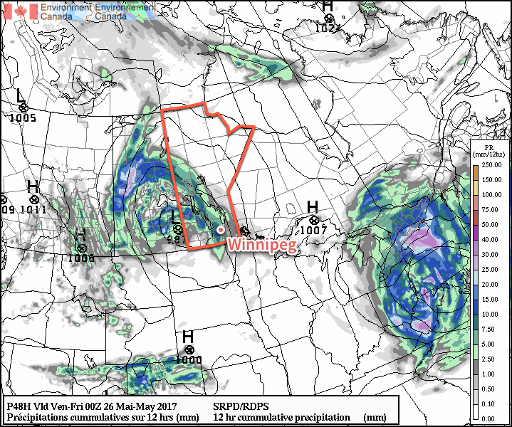
As a result, Winnipeg will see sunny skies today and tomorrow with daytime highs near 24 and 27°C respectively. The upper ridge will move east of the Red River Valley on Friday, and a disturbance will begin moving towards the province out of southern Alberta. Friday will still be quite pleasant, however, with partly cloudy skies and a high near 25°C.

The above-normal 500mb heights (red) will result in seasonably warm temperatures for Winnipeg

Winds will be out of the west today at 10-20 km/h, calm on Thursday, and strengthen out of the southeast to 20-30 km/h on Friday afternoon.

Expect overnight lows around 10-12°C the next few nights.

Long Range

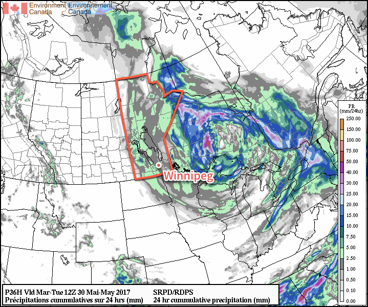
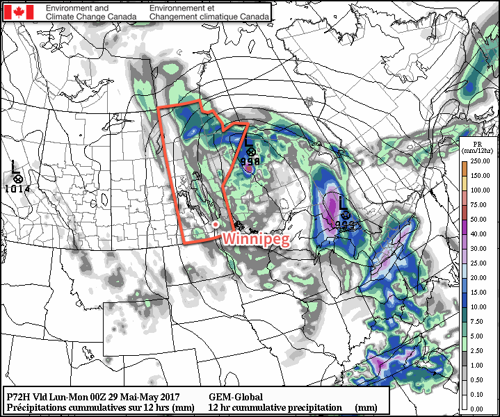
At this point, it seems quite likely that a low pressure system will move through late overnight on Friday into early Saturday morning. This system may end up being the first organized nocturnal thunderstorm event of the season, and would likely move into Winnipeg & much of the Red River Valley on Saturday morning. Whether or not there end up being thunderstorms, rain is definitely likely with anywhere from 5-20 mm possible as it moves through.

There’s uncertainty in how quickly this system will clear out, so Saturday may end up remaining fairly cloudy, or we may see sunshine build back into the region in the afternoon. Sunday will likely bring mixed skies to the region again. Both days look to bring highs around 20°C to Winnipeg and lows near 10°C.

After the weekend, Winnipeg should see a couple more dry days before another chance for unsettled conditions mid-week.

Winnipeg’s seasonal daytime high is currently 22°C while the seasonal overnight low is 9°C.

One More Damp Day, Then May Ends With Nicer Weather

Winnipeg will be under the influence of the storm system that has been bringing showers to southern Manitoba the past couple days for one more yet, but then a return to more pleasant weather will quickly return for the end of May!

More showers are on the way for Winnipeg today as moisture continues to stream southwards through the province on the back-side of the storm system that moved through over the weekend. Breezy northwesterly winds of 30 gusting 50 km/h will make today’s high of just 11°C feel rather dreary. The chance for showers will continue tonight, although it won’t be quite as likely, as temperatures drop to a low near 6°C.

More showers are expected across much of Manitoba today and tonight.

Sunshine will return to Winnipeg on Tuesday as skies clear for the afternoon. There will be a slight chance of showers in the morning as one more little disturbance ripples through, but as skies clear midday temperatures will warm up to a high near 18°C. The wind will continue to be gusty out of the northwest, but the sunshine should make for a much more pleasant afternoon. Skies will completely clear out by evening as winds taper off and Winnipeg heads to a low near 8°C.

Wednesday will be a beautiful day to end the month on; sunny skies with a high near 24°C are on the way with light winds of just 10-20 km/h out of the west. The low will be relatively mild on Wednesday night at around 10°C.

Long Range

The remainder of the work week looks pleasant with continued sunny to mixed skies and highs in the low 20’s. A system will approach Manitoba on Friday, but at the moment guidance suggests it will remain to the south and west. There is general agreement that next week may turn more unsettled once again, so we’ll be keeping an eye on that as the week progresses.

Winnipeg’s seasonal daytime high is currently 22°C while the seasonal overnight low is 8°C.

Weather Tanks For Yet Another Weekend

The weekend is coming! You know what that means! Conditions will slide over the next few days as today’s sunny skies get replaced by clouds and rainy weather as the weekend progresses.

Today will be a relatively nice day as Winnipeg sits on the edge of the dry slot of the storm system that brought damaging winds to Alberta and 25-50mm of rain to a large swath across Alberta and Saskatchewan. This system will continue to trek east-northeastwards, but is now weakening as it does so. We aren’t free from it yet, though; it’s going to make its way back to Winnipeg before the weekend is through.

As mentioned before, today will be quite nice with skies becoming partly cloudy and a high climbing to around 21°C with winds out of the west at 15-25 km/h. There’s a slight chance of a some rain showers this afternoon and evening, but then skies will clear as temperatures head to a low near 10°C.

Saturday will bring increasing cloud through the day with a very slight chance of a rain shower towards evening. The high will again be right around 20°C with a west wind in the 15-25 km/h range. Expect cloudy skies on Saturday night with an increasing chance of rain showers towards morning. The low will be around 9°C.

Guidance shows Winnipeg being clipped by showers moving southwards out of the Interlake on Sunday

As shown above, Sunday will likely be on the wetter side as Winnipeg fully moves onto the back side of this storm system and breezy northwesterly winds near 30 gusting 50 km/h. Rain showers are expected to move across the region throughout the day while the high temperature will be much cooler than Friday and Saturday at just 15°C. Expect continued cloudy skies with chances for rain on Sunday night as temperatures dip to a low near 9°C.

Long Range

Monday continues to look unsettled with cool temperatures and a chance for showers, but it then seems Tuesday will bring some sunshine back to the region and start the rebound back towards seasonal temperatures. The drier and warmer weather looks like it will stick around for the remainder of the week, but there are some hints that we may see another system ruin another weekend. Why would it be any different?

Winnipeg’s seasonal daytime high is currently 22°C while the seasonal overnight low is 8°C.

Mixed Bag For Second Half of the Work Week

Winnipeg will dodge the worst of a major storm system that will slam Alberta and portions of Saskatchewan with strong winds and rain; comparatively, things will be quite pleasant!

A major storm is developing over Alberta today that will bring 30-50 mm of rain to the province alongside winds gusting over 100 km/h. This system will spread eastwards and bring significant weather to Saskatchewan later today, but will begin to weaken as it approaches Manitoba overnight. While Winnipeg will be spared from the brunt of this storm, some breezy and unsettled weather is still on the horizon.

First up, today will be a warm and windy day as moderate southerlies develop ahead of the Alberta storm. We should see fairly sunny skies, but winds will pick up out of the south-southeast to 30-40 km/h with gusts to 60 km/h through the morning and early afternoon. Temperatures will be near-seasonal with a high of 21°C.

The winds will continue out of the south-southeast tonight at around 30 gusting 50 km/h as cloud cover pushes in late overnight. Temperatures will drop to a low near 11°C.

Thursday will bring cloudy skies to the region as a trowal1 moves through the region. Whether or not Winnipeg will see rain is still somewhat uncertain; support for it definitely tapers off as the feature moves into the Red River Valley, but it will likely be able to sustain a band of rain or showers that will move through mid-day. A second batch of showers is possible in the early evening as the low pressure system moves into the Interlake.

More recent model runs are beginning to show accumulating rainfall in the Red River Valley on Thursday

While the winds will be breezy first thing, they should diminish through the morning as the low approaches. Temperatures will reach a high near 18°C. Temperatures should dip to around 12°C on Thursday night with the cloud cover breaking up.

Friday will bring mixed skies to Winnipeg & the Red River valley with a high near 19°C. It should stay dry, with any showers to our east and north. Winds will be out of the west at 15-25 km/h. It looks like skies should be fairly clear on Friday night as temperatures dip to a low near 9°C.

Long Range

The mixed bag continues this weekend with Saturday likely bringing a fair amount of sunshine and highs near the 20°C mark, but things take a turn on Sunday with highs dropping into the mid-teens as showers slump southwards out of northern Manitoba. With breezy northwesterly winds, it will likely be a relatively unpleasant day. The unsettled weather may persist into Monday, but then the remainder of next week looks pleasant with dry conditions and highs in the low 20’s.

Winnipeg’s seasonal daytime high is currently 21°C while the seasonal overnight low is 7°C.


  1. Trowal stands for “trough of warm air aloft” and is the warm air rising around a low pressure system from the occluding frontal wave.