Weather Deals a Dud for Solar Eclipse?

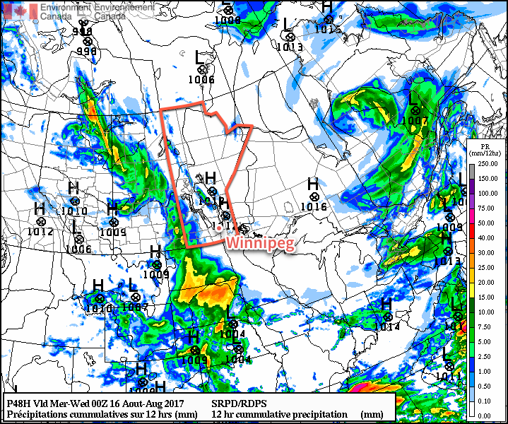
Extensive cloud cover across the Red River Valley and southeastern Manitoba threatens to spoil the opportunity to see this year’s rare solar eclipse. On the flip side, if you’ve been waiting for some moisture, showers are likely across the Red River Valley today.

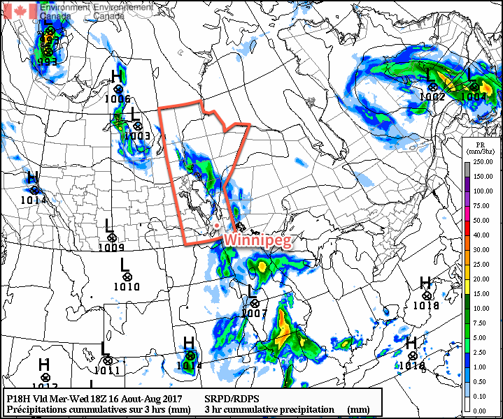
An upper-level disturbance tracking along the international border today will spread clouds and showers across Southern Manitoba early this morning and into the afternoon. Amounts will be rather low, with general amounts of 1-4 mm expected, although a bit of elevated instability associated with the system may end up producing some heavier showers or thundershowers that result in isolated patches of 5-10 mm of rain. Winds will be light out of the south to southwest until a cold front approaches in the afternoon, shifting the winds behind it to the northwest at 20-30 km/h. Temperatures will be cool due to all the cloud cover and/or showers with highs across the Red River Valley near 22°C.

Simulated image of the 2017 solar eclipse at peak coverage in Winnipeg, MB.

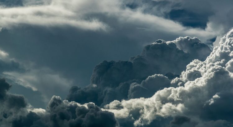
Unfortunately, it will likely be mainly cloudy across all of the Red River Valley during the solar eclipse.1 The image above shows what it would look like for our region should we see sunshine; even at 75% obscuration, there would actually be only a marginal impact on overall brightness and it would not be nearly as dramatic as areas along 90%+ obscuration or the path of totality, where temperatures will actually drop a few degrees because the loss of sun is so substantial. Note: There is a small chance that the cloud cover may break up for a bit around the eclipse time; we’ll be keeping an eye on it and post updates on social media if that seems to be the case!

The cloud will begin moving out in the afternoon and if there manages to be enough sunshine, it could trigger an isolated thundershower or two along an approaching cold front. Temperatures will dip to a low near 12°C under partly cloudy skies on Monday night.

Temperatures will be below seasonal (blue) across southern Manitoba on Tuesday with a northwest flow.

Tuesday will also be a cool day across the region as a colder airmass moves in with a northwesterly flow. Winds will breezy at 30-40 km/h as temperatures once again climb to near the 22°C mark once again. Skies will be partly cloudy, and by the afternoon there will be a slight chance of a shower developing in the Interlake and drifting south/southeastwards along a weak trough that develops through the region. The chance for rain will likely be confined to Winnipeg & the northern Red River Valley. Temperatures will head to a low near 11°C as winds taper off and skies clear on Tuesday night.

Wednesday will see a return to more seasonal conditions. Winds will be light as a ridge of high pressure moves through the region and temperatures will reach a high near 24°C under partly cloudy skies. Expect mixed skies and a low near 12°C on Wednesday night with a slight chance of some showers as a frontal boundary slumps southwards.

Long Range

The latter half of the week looks quite summer-like with temperatures back into the upper 20’s and a fair amount of sunshine skies. There will be another chance of showers on Thursday night into Friday morning as that same boundary that moved through on Wednesday night reverses and starts heading back northwards.

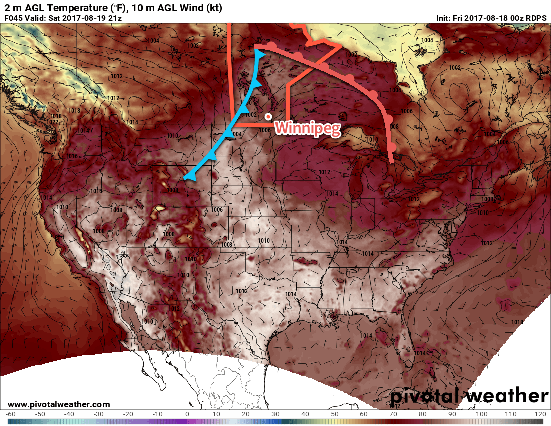
The next large-scale organized chance for rain comes on Saturday as a large push of warm air moves into the region, producing showers and thunderstorms from northern Saskatchewan to South Dakota. It won’t be a solid line, and intensity will vary, so it’s going to be the kind of situation where it won’t be too clear until much closer to the event.

After Saturday’s system, it looks quite pleasant with near-seasonal temperatures and sunny skies.

Winnipeg’s seasonal daytime high is currently 24°C while the seasonal overnight low is 11°C.

  1. The solar eclipse begins at 11:40AM, peaks with 75% obscuration at 12:57PM CDT, and ends at 2:15PM. If by chance we see sun, under no circumstances should you look at the eclipse without eye protection. Blindness can occur in as little as 20-30 seconds.

Warm Weekend Arrives With A Slight Chance of Thunderstorms

The weekend will bring a fair amount of warmth to Winnipeg and the Red River Valley, but alongside it will come some chances for isolated to scattered showers or thunderstorms.

Today will begin with an upper-level disturbance sliding out of southwestern Manitoba into North Dakota. As it moves eastwards, it will spread some cloud into the Red River Valley along with along with a low chance of isolated to scattered showers or thunderstorms further south in the valley towards the Morden-Winkler-Altona area. The partly cloudy to mixed skies will clear out through the morning and early afternoon, leaving sunny skies as temperatures climb to a high near 28°C. Winds will be relatively light out of the west to northwest at 10-20 km/h. Expect clear skies tonight with calm winds as temperatures head to a low near 15°C, kept relatively mild by a warm front that moves through in the evening and overnight hours.

Saturday will be a scorcher over southern Manitoba as we move into the warm sector of a low pressure system tracking across the northern Prairies. Temperatures will climb towards a high near 32°C under mainly sunny skies with winds becoming fairly breezy out of the south at close to 30 km/h for the afternoon. Fortunately, humidity shouldn’t be too much of an issue. Late in the afternoon, a cold front will begin pushing across southwestern Manitoba into the Red River Valley, and that will bring with it a risk of thunderstorms. At this point, it looks like there will be a slight chance of strong to marginally severe thunderstorms moving from west to east through the Red River Valley from around 6-7PM until midnight. Temperatures will then head to a low near 15°C again with gusty northwesterly winds behind the cold front tapering off overnight.

Temperatures will climb into the low 30’s across Southern Manitoba on Saturday afternoon ahead of an approaching cold front.

Sunday will bring cooler temperatures to the region as breezy westerlies at 20-30 km/h develop and highs reach a near-seasonal 25°C or so. Skies will partly cloudy and there may be an isolated shower or two passing through, but no particularly intense rain is expected. Expect mixed to cloudy skies on Sunday night as temperatures dip to a low near 14°C.

Long Range

Next week will start with mixed skies and near-seasonal temperatures and continue that way through much of the week, albeit with a bit more sunshine working in as the week progresses. It looks fairly dry at this point with no significant threats for rain on the horizon until next weekend. It appears that temperatures will creep towards the upper 20’s once again as the week progresses. Overall, it looks like it’ll be another warm and dry week.

Winnipeg’s seasonal daytime high is currently 25°C while the seasonal overnight low is 11°C.

Cool Wednesday Just A Speed Bump; Warm Weather Quickly Returns

Today will be a rather cloudy, cool and unsettled day across the Red River Valley as a trough of low pressure swings through the region. The wet weather will be short-lived, though, and there will be a quick return back to sunny and warm weather.

The wet weather moved in overnight and will taper off this morning, leaving mostly cloudy skies until sometime in the afternoon when some sunshine will begin breaking through. Temperatures will be cool for mid-August with a high of just 23°C. There will be a slight chance of a shower or thundershower this afternoon if enough sunshine pops out and warms things up even a little bit more than expected.

The cloud will clear out in the evening, leaving Winnipeg with clear skies as temperatures head to a low near 13°C.

RDPS 3hr. Precipitation Totals valid 18Z Wednesday August 16, 2017
The RDPS shows the main area of rain tapering off before 10AM across the Red River Valley.

Thursday will bring summer weather back to Winnipeg. Aside from a bit of morning low cloud or fog, skies will be partly cloudy with temperatures rebounding back towards a high near 27°C. Some cloud cover will begin working into the region in the evening ahead of an incoming low pressure system. This system will spread scattered showers into southwestern Manitoba overnight as it slowly moves east-southeastwards, but should remain west of the Red River Valley. Temperatures will dip to a low near 15°C under mixed skies on Thursday night.

RDPS 24hr Precipitation Totals valid 00Z Saturday August 19, 2017
The GDPS shows the potential for wet weather across portions of the Red River Valley on Friday.

Friday will continue to be warm, but skies will be mixed as a low pressure system passes to the south of Winnipeg. Highs near 28°C combined with the low moving through will bring showers and the risk of thunderstorms to the Red River Valley. Depending on the exact track of the low, everything may end up to the south of Winnipeg, but at this point there’s still enough of a chance of seeing something here that it’s worth mentioning. Things will clear out for Friday night as temperatures head to a low near 15°C.

Long Range

Once we get past Friday’s weak disturbance moving through the region, things turn more settled once again with generally warm and dry conditions. Daytime highs will climb to the upper 20’s through the weekend with overnight lows continuing in the mid-teens. The start of next week continues to look nice with warm, dry conditions expected.

Winnipeg’s seasonal daytime high is currently 25°C while the seasonal overnight low is 12°C.

Cloudier Conditions Follow A Sunny & Warm Monday

Winnipeg has seen an abundance of sunshine lately, but it comes to an end on Tuesday as extensive cloud cover moves into the region ahead of a low pressure system that will bring unsettled weather to the region.

Before the cloud moves into the region, Winnipeg will get another beautiful day today with plenty of sunshine and highs approaching the 30°C mark. Winds will remain light through the day and the humidity will still be quite comfortable. All in all a great summer day.

RDPS 2m Temperature forecast valid 21Z Monday August 14, 2017
Highs across much of Manitoba will climb into the upper 20’s or low 30’s on Monday.

Clouds will move in on Monday night as temperatures dip to a low near 15°C and the winds become light out of the south.

Tuesday will bring mostly cloudy skies to Winnipeg with winds picking up out of the south to 20-30 km/h. Scattered showers or thunderstorms are likely over the southwest corner of the province, but things should stay dry in the Red River Valley. Expect cloudy skies on Tuesday night with a low near 17°C and a slight chance of showers.

RDPS 12hr. Precipitation Totals valid 00Z Wednesday August 16, 2017
An area of showers and/or thunderstorms will move into southwestern Manitoba on Tuesday evening.

Wednesday will bring slightly cooler temperatures to Winnipeg as highs reach just around 23°C under cloudy skies. There will be a good chance of showers, particularly through the morning hours. Winds will be out of the east at around 15-25 km/h. Conditions will slowly settle through the afternoon and there may even be a few sunny breaks. Expect the clouds to clear out on Wednesday night as temperatures dip to a low near 15°C.

Long Range

Once this system moves out, it looks like another long stretch of warm and dry conditions. Thursday through next Tuesday looks warm with highs around the 27 or 28°C mark with plenty of sunshine. A couple disturbances will move through over those days and bring a low chance for some thunderstorms, but at this point models disagree significantly on their placement and how much, if anything, they’ll be able to produce. We’ll be keeping an eye on it and have more details in Wednesday’s forecast post.

Winnipeg’s seasonal daytime high is currently 25°C while the seasonal overnight low is 12°C.