Major Winter Storm on the Doorstep

A winter storm rapidly developing over North Dakota will spread snow, freezing rain and showers into Manitoba today, along with increasingly strong northwesterly winds. Conditions will deteriorate rapidly this morning over western Manitoba, while the Red River Valley and southeastern Manitoba see conditions deteriorate later this afternoon when temperatures begin to drop and any showers change over to snow.

Winnipeg Forecast

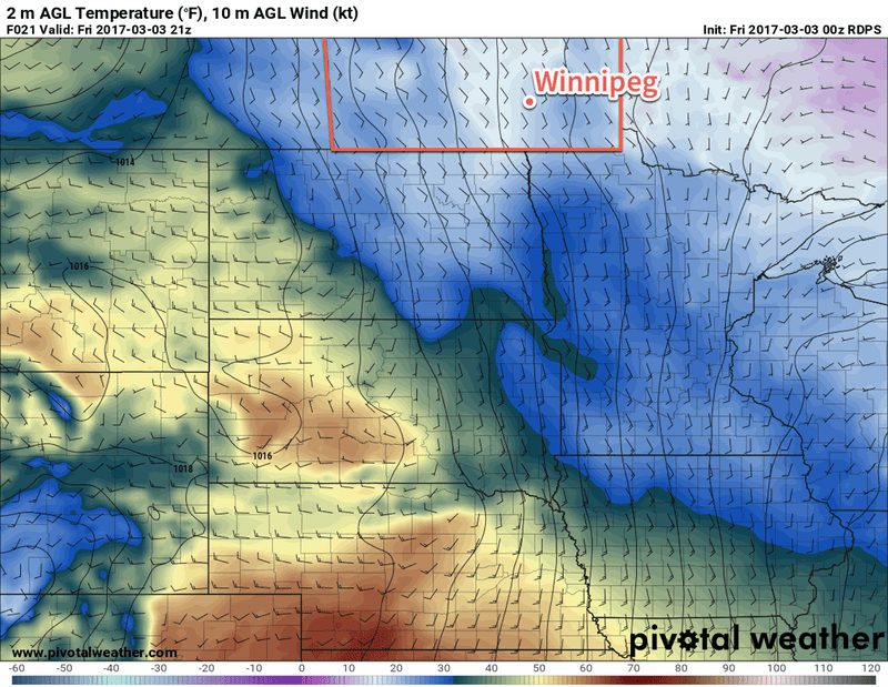
Warm air will be reinforced over the Red River Valley ahead of this low pressure system as east to southeasterly winds increase to around 30 gusting 50 km/h develop, keeping temperatures mild with highs near 3°C today. An area of showers will develop as the main low centre lifts into the province out of North Dakota a bit later in the morning, spreading northwards through the afternoon. Rainfall totals throughout the Red River Valley will be variable thanks to the showery nature of the rain, but in general between 2-10mm seems most likely. If some more intense showers develop, there may be a chance for isolated accumulations of 10-20 mm.

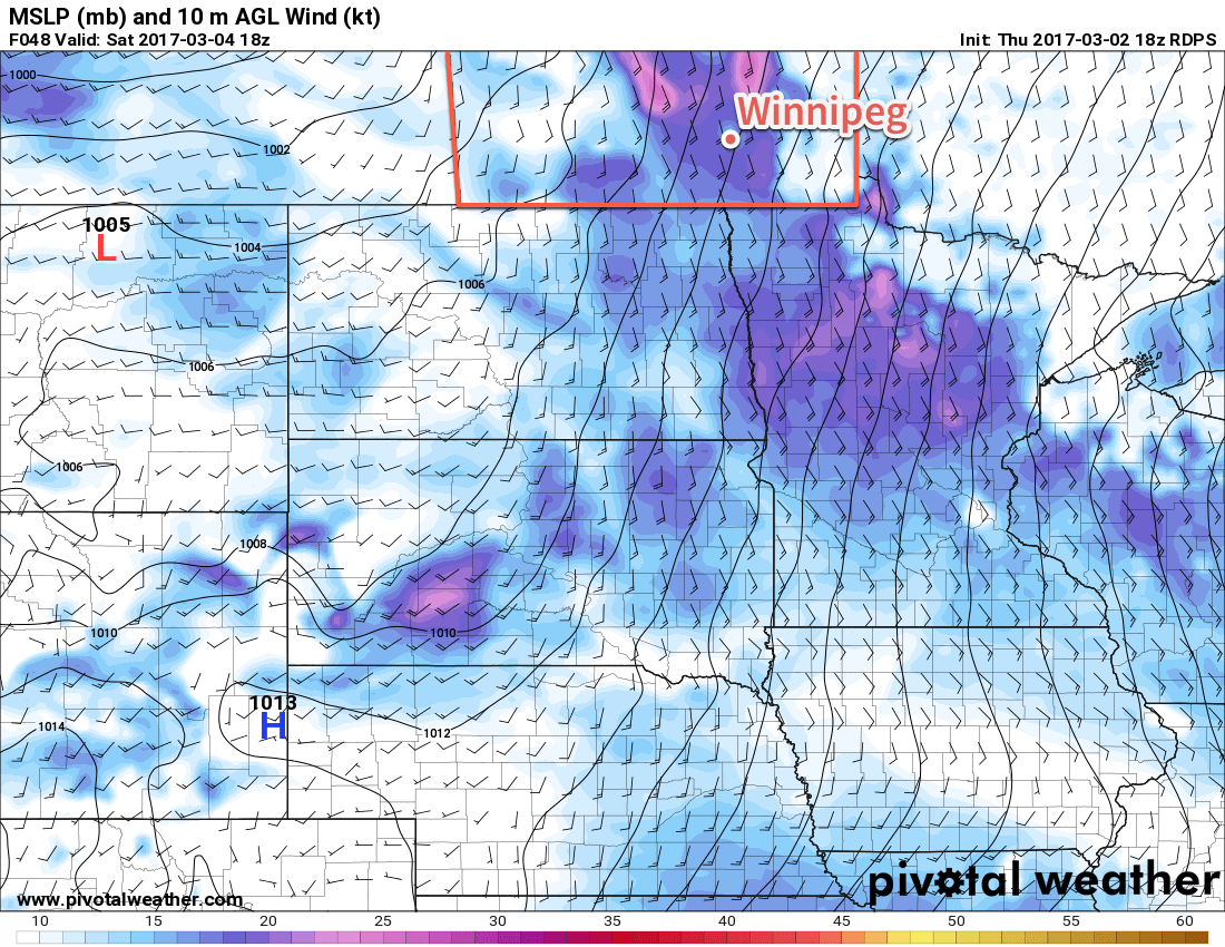
Winds will taper off late this afternoon into the early evening as the centre of the low passes through the region. As it moves off to the northeast, winds will then abruptly strengthen out of the west to northwest at 40-50 km/h with gusts up to 70 km/h. Temperatures will quickly drop below zero as some wrap-around snow moves into the Red River Valley.

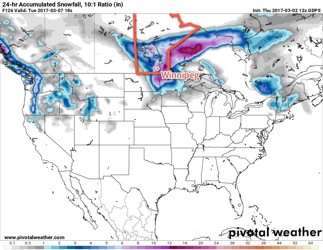
While some earlier forecasts were showing significant snowfall in the Red River Valley, it looks like the bulk of the snow with this storm will fall over western and northern Manitoba. Here in the valley, the best current indications are that we’ll see a couple centimetres of snow. There are a few outlier models that suggest a secondary shortwave could produce heavy snow over the region in the second half of the night, but I don’t have a lot of confidence in that. I’ll be providing updates via our Facebook and Twitter pages tomorrow night.

The strong winds will persist all night, which when combined with a couple centimetres of new snow may be enough to create local areas of poor visibilities in blowing snow. Temperatures will drop to a low near -10°C.

Tuesday will bring more periods of snow to the Red River Valley with continuing strong winds out of the west. Temperatures will remain steady near around -11 or -12°C. Temperatures will drop to around -16°C on Tuesday night with more strong winds. Any remaining light snow should taper off overnight.

Wednesday will bring an end to the influence of this storm system. The clouds should break up a bit as the winds taper off through the day. Temperatures will remain cool with a high near -10°C. Expect some more clear breaks overnight as an Arctic ridge pushes into the region. Temperatures will fall well below normal with a low near -19°C.

The Big Picture

Rainfall

Rainfall will be the primary story for much of southern Manitoba today as an area of showers develops ahead of a warm front lifting northwards from the United States.

Areas in Manitoba that will see rainfall today.

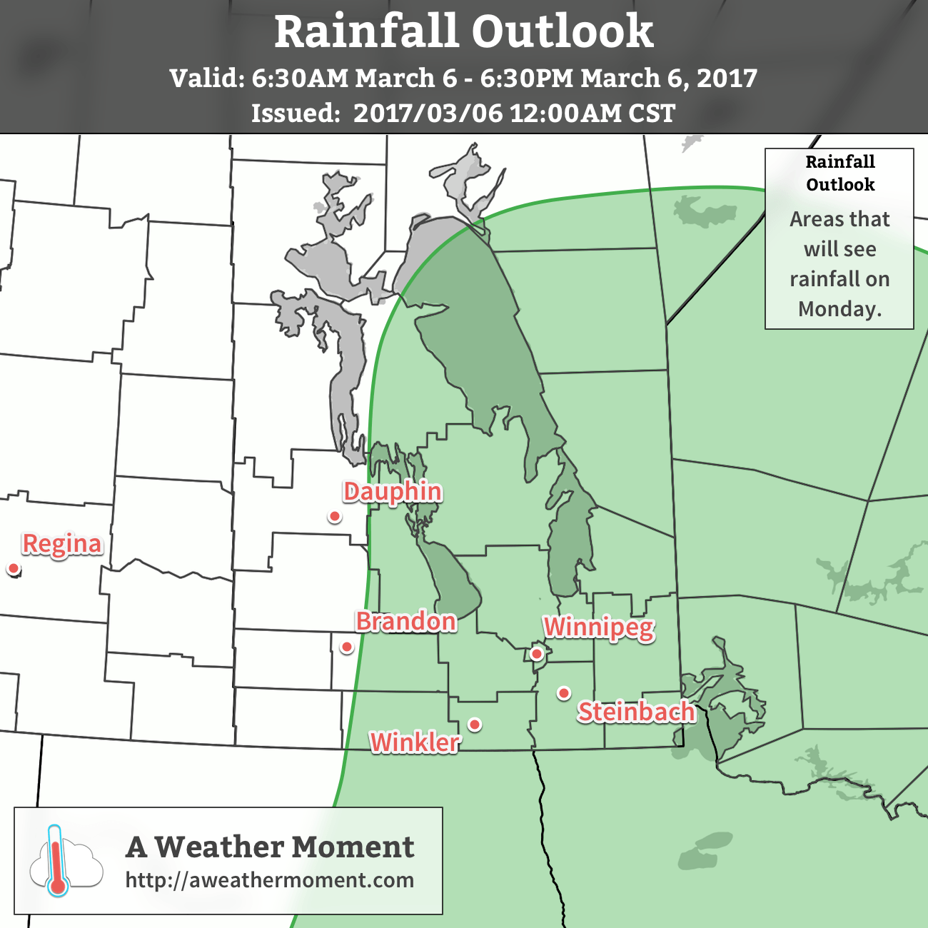
The biggest unknown is exactly how much rain will fall, which will depend on how intense the area of showers can manage to develop. At the moment it looks like most areas will see 2-5 mm, however there is the potential for higher widespread amounts of 10-15 mm further north in the Interlake. Should any potent convective cells develop, which may happen anywhere in the rain area today, they may be capable of producing isolated accumulations of 10-20 mm.

The rain will move out of the province this evening, replaced by snow.

Freezing Rain

The risk of freezing rain will appear today through western Manitoba into the Interlake.

Freezing rain is possible over western Manitoba & the Interlake today and into tonight.

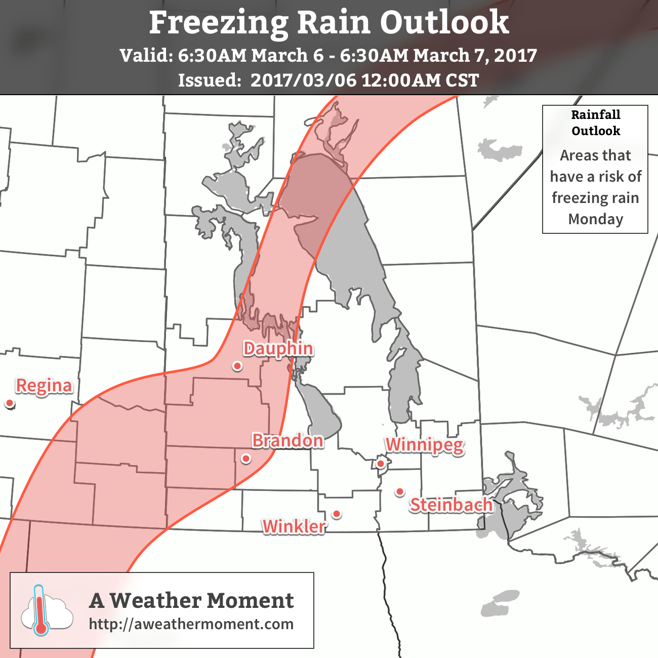
The threat for freezing rain will move into western Manitoba this morning and persist until midday. Accumulating freezing rain is possible, with the risk for several mm of ice accumulation. This threat will then lift into the Interlake for the afternoon and onwards into northern Manitoba tonight.

Snowfall

The major impact from this storm will the snowfall and associated winds.

A major snowfall event will occur over eastern Saskatchewan, western Manitoba and northern Manitboa with this winter storm.

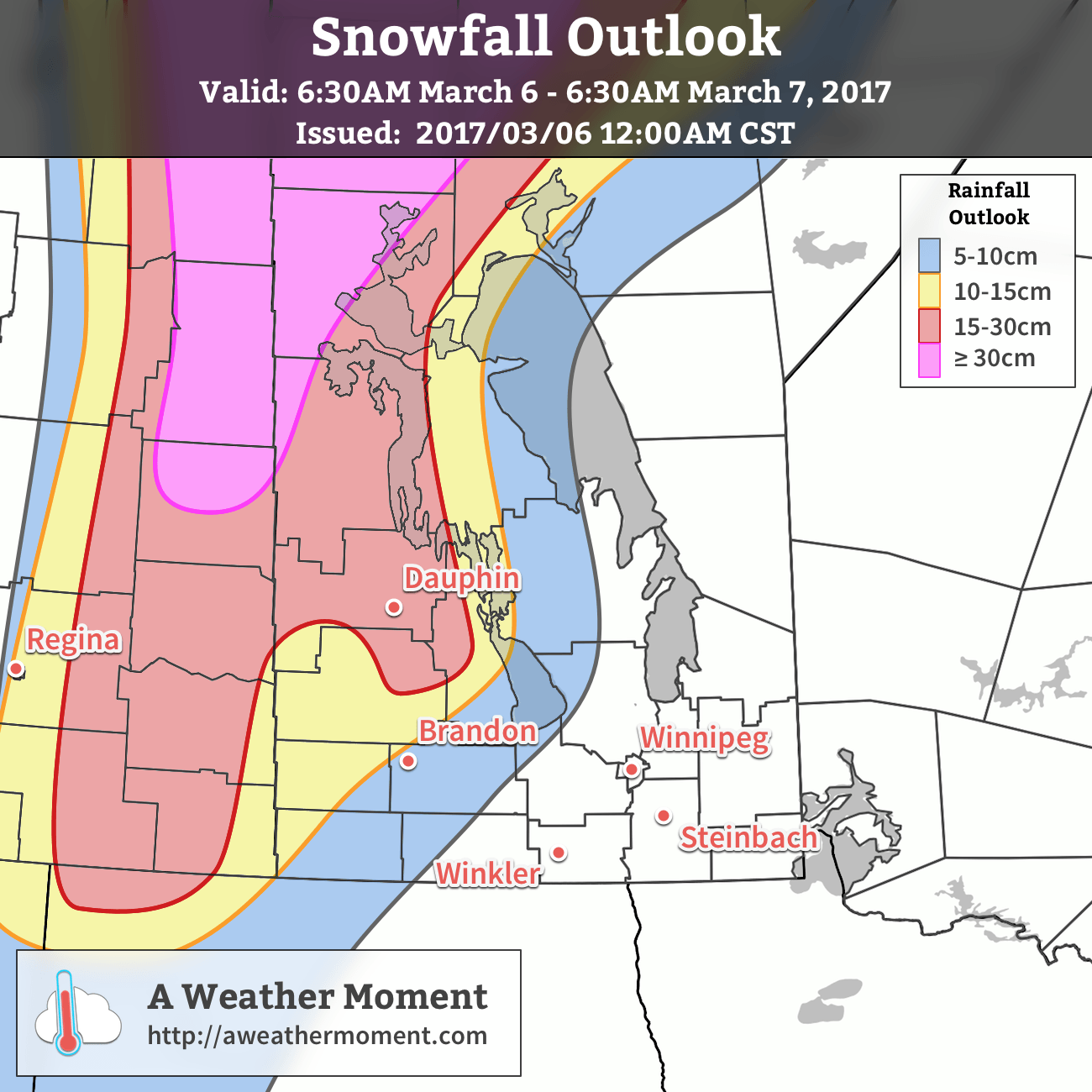
The snow is already falling across eastern Saskatchewan and northern Manitoba and will spread eastwards into western Manitoba for the afternoon. Snowfall amounts will be major, with upwards of 40-50 cm expected to fall through the heaviest band in Northern Manitoba. Further south, a north-south swath of 10-30 cm will pile up by Tuesday morning. There will be a relatively sharp cut-off from the heavy snow to just minor accumulations on both the eastern/southeastern and western flanks.

This heavy snow will combine with strong northwest to westerly winds to produce an extended period of blizzard conditions, likely lasting over 24 hours. If you are in the areas that will see heavy snow move in today, it will be best to avoid all travel until conditions improve.

Long Range

Once everything finally calms down on Wednesday, we’ll move into an extended period of below-normal temperatures with daytime highs falling to the mid-minus teens and lows falling below -20°C. No precipitation is expected in the second half of the week.

Winnipeg’s seasonal daytime high is currently -4°C while the seasonal overnight low is -14°C.

Blast of Pacific Warmth On The Way

After a couple days of below-normal temperatures, significantly warmer weather is on the way as a wave of warmth surges eastwards across the Prairies. The transition may be a little uncomfortable, but a mild weekend lays ahead.

Today will begin the transition to warmer weather in the Red River Valley. That means that while we see the hope of warmer temperatures, we’re buffeted by the reality of harsh southerly winds in the still-present cold.

Those south to southeasterly winds will pick up this morning and strengthen to around 30 km/h. Today won’t have a “high temperature” so much as a “climbing temperature.” By this evening, the temperature will have climbed to -7 or -6°C and then will continue to rise overnight to near -5°C by Saturday morning. The winds will remain breezy out of the south to southeast overnight. Skies will cloud over as the day progresses.

The RDPS shows temperatures climbing to around -7°C this afternoon.

Saturday will see very mild temperatures move into the region as highs climb to about +3°C. However, the winds will strengthen in the morning and then continue through much of the day, sustained near 40 km/h with gusts on top of that. Skies will remain mostly cloudy, but the odd glimpse of sunshine is possible. Winds will diminish fairly quickly in the evening as temperatures fall to a low near -3°C under mixed to mostly cloudy skies.

Strong southerly winds will be in place over the Red River Valley on Saturday

Sunday will bring mixed to mainly cloudy skies and much lighter winds to the region. With temperatures still climbing to +1 or +2°C, it will be probably the most pleasant day of the next 3. There may be a small chance of some light snow or rain, but indications are that the band will remain light and likely pass northwest of the Red River Valley. Temperatures will then drop to around 0°C on Sunday night with the cloud cover thickening up.

Long Range

The beginning of next week poses a bit of a challenge as a pair of low pressure systems begin developing over Montana and Colorado, then progress to merge into a potent low pressure system over Nebraska that then lifts north-northeast towards Lake of the Woods.

This system will begin developing on Sunday, with the northern flank of precipitation spreading across southern Saskatchewan and into western Manitoba. A second wave of precipitation is forecast to develop on Sunday night, potentially spreading across SW Manitoba and into the Red River Valley by Monday morning.

Then, as the system intensifies on Monday, the northern flank is to collapse somewhat as all of the energy focuses around the surface low, spreading fairly intense precipitation northwards through the Dakotas and Minnesota into south-central and southeastern Manitoba.

The GDPS is showing up to 6-8″ of snow in Winnipeg next Monday/Tuesday, but that’s probably not worth much at this point.

There are a lot of uncertainties associated with this system as of Friday morning. Whenever these deep, potent Colorado Low systems develop with a precursor low further north, there end up being numerous interactions between the two systems that complicate their energy distribution. While the overall solution is believable1, the details matter and are fairly fuzzy at this point. This system will be a combination of rain and snow and have a sharp western/northwestern edge, so a shift of even 50km may mean the difference between snow or nothing, or between some rain or 10 inches of snow.

We’ll be keeping a close eye on this system, and may issues our Monday forecast on Sunday evening if it looks like the system is going to be of significant impact early in the day on Monday. Enjoy the mild temperatures until then, hopefully the wind isn’t too uncomfortable!


  1. It’s favoured for the southern low to overtake the northern low as it receives more energy from the upper-level jet circulation to its southeast. 

Cold Front Brings Late-Season Chill

A weak cold front passing through the region this morning will bring cooler weather to the Red River Valley for the second half of the work week, but it will be short lived as a widespread push of milder air develops through the weekend.

Today will bring near-seasonal temperatures to Winnipeg alongside some light snow as a cold front sweeps through this morning. Winds will pick up slightly out of the north behind the front as cooler air begins pushing southwards into the Red River Valley. Despite this, the high temperature should reach around -8°C; the bulk of the cold air will move in tonight as temperatures are set to slump to slightly below-normal -18°C.

This cold air will be in place through Thursday as temperatures struggle to climb to a high near just -13°C, which is well below-normal for this time of year. We should see a fair amount of sun, though, so as long as you haven’t put away your mitts and toque, it will be a relatively nice day. Temperatures will dip down to around -18°C again on Thursday night under partly cloudy skies.

A series of impulses moving in from the Pacific will spread warmer air into the eastern Prairies.

Friday will bring the big swing as the first of several Pacific-sourced systems tracks across the central Prairies. Warmer air will surge eastwards towards Manitoba, producing gusty southerly winds as is typical with transition days from colder to warmer weather in the Red River Valley. They’ll probably strengthen to around 40 km/h with gusts up to 60 km/h, and persist into Saturday morning before tapering off Saturday afternoon. Temperatures will climb, though, eventually reaching a high temperature near -5°C. Along with the warmer weather will come more cloud, with skies clouding over by midday. While any accumulating snow is unlikely, there may be some light snow in the afternoon as the warm front pushes across the Red River Valley.

Skies should mix out a bit on Friday night as temperatures continue near -5°C or even rise slightly towards -3 or -2°C by Saturday morning.

Long Range

Mild weather will remain over southern Manitoba for the weekend, with daytime highs continuing to be above seasonal. By Sunday, the chance for snow will increase as a more significant low pressure system develops across the Northern Plains.

Winnipeg’s seasonal daytime high is currently -5°C while the seasonal overnight low is -15°C.

Cool Weekend Ahead; Light Snow Possible Saturday

The weather will be relatively quiet over the coming few days with slightly below-seasonal temperatures in place. The only real weather to note will come on Saturday as a weak low pressure system tracks along the US-Canada border and brings the chance for some light snow to the region.

Today will bring a daytime high near -8°C with partly cloudy skies and light winds. Expect a low near -13°C tonight with increasing cloud.

Saturday will be a mostly cloudy day as a low pressure system skims along international border. Temperatures will top out around -6 or -7°C in the Red River Valley with a decent chance of some light snow in the region, particularly through the afternoon. Minor accumulations may occur, but only really enough to make roads a bit slick again. Winds will continue to be fairly light. Temperatures will dip down to around -14°C on Saturday night with clear breaks developing.

The 00Z run fo the RDPS shows the potential for 1-3cm of snow on Friday across southwest and south-central Manitoba.

Sunday will be be a return to quiet weather with a high near -6°C, light winds and mixed skies. Lows will drop to around -12°C on Sunday night with mixed skies continuing.

Ultimately, there’s a slack pressure pattern for the coming few days and with the storm track well to our south. This will result in a few days that are mostly slight variations of each other.

Long Range

Temperatures are expected to return to seasonal values for much of next week. At this point, it appears that there are no threats for any notable snowfall events until late next week, so fairly quiet weather ahead.

Winnipeg’s seasonal daytime high is currently -6°C while the seasonal overnight low is -16°C.