Extended Period of Unseasonal Warmth On The Way

A highly anomalous November weather pattern will set up through the remainder of the week, bringing an extended stretch of warm and dry weather to the Red River Valley.

Today will be the last cool, cloudy day for the next while, all thanks to a building 500mb ridge that will dominate the weather pattern for at least the next 5-7 days. Before that happens, though, we’ll need to power through a large deck of stratus cloud working across the Prairies. As a result, today will be fairly cloudy, perhaps a few sunny breaks here and there, with temperatures topping out at a slightly above-seasonal 6°C.

There’s a very slight chance of an afternoon/evening rain shower today as a weak impulse moves over the Red River Valley, but if it were to happen, it would be short-lived and not produce any measurable accumulation. Skies will clear overnight as temperatures drop to around 1°C.

Thursday will bring significantly nicer weather as a large upper-level ridge builds into the Prairies:

An upper-level ridge will build over the Prairies beginning Wednesday evening through Saturday.

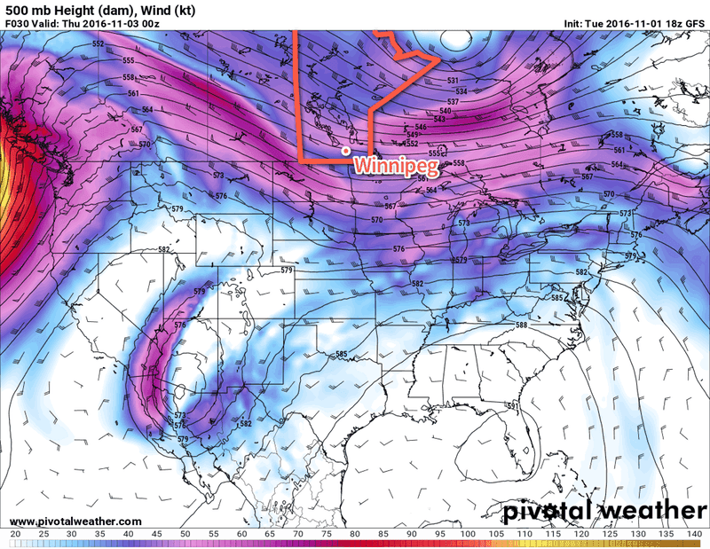
This will bring more sun to the region as our mostly cloudy skies are replaced by partly cloudy skies both Thursday and Friday. Temperatures will also be well above seasonal with high temperatures in the 12-15°C range. While these are over 10°C above normal, they likely won’t be record-setting, as the record high temperatures are surprisingly warm for the beginning of November:

Record High Temperatures in Winnipeg for November 2-4
Date Record High Year Set
November 2 21.7°C 1903
November 3 18.8°C 2008
November 4 20.0°C 1975

Winds will be relatively light both Thursday and Friday at just 10-20 km/h.

Long Range

The long-range forecast is looking quite pleasant overall. Warm temperatures will continue to dominate the weather story throughout the first half of November as the upper-level ridging continues over the Prairies.

This forecast of 500mb heights for November 11th shows the highly anomalous heights over the Canadian Prairies.

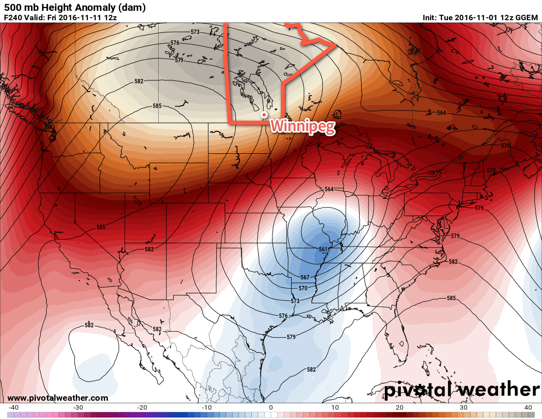
There may be dips in the temperature here and there with the occasional passing disturbance, most likely back to slightly above-seasonal values, but the upper-level ridge will rebound and push milder air back into the region. Conditions should remain fairly dry through this period as well.

Winnipeg’s seasonal daytime high is currently 5°C while the seasonal overnight low is -5°C.

Friday’s Disturbance Leads To Cooler Weekend

Cooler, more seasonal temperatures will push into Winnipeg & the Red River Valley this weekend behind a low pressure system that will bring rain to portions of Southern Manitoba on Friday.

Today will bring a low pressure system, talked about in Wednesday’s forecast, through the province. In that post, we discussed how there was uncertainty in the track of the low, and that it seemed like much of the rain associated with it would fall across the Interlake. With the system imminent now, it’s become readily apparent that it will indeed primarily affect areas to the north of Winnipeg, at least for much of the day today.

Today will be a cloudy one across Winnipeg & the Red River Valley with light winds and temperatures climbing to a high near 12°C. Late this afternoon, winds will pick up out of the northwest to around 30 km/h, bringing with them a chance of some rain as a cold front sweeps southwards across the province. No significant accumulations are expected in Winnipeg, unlike the further north where 15-25 mm are possible along a west-east line running from Swan River eastwards across the Northern Interlake and Berens River.

With the gusty northerly winds and light showers tonight will come dropping temperatures. Lows should sit near 2°C tonight with winds tapering off towards Saturday morning. With the cooler temperatures and northwesterly winds, there may also be more persistent shower activity in the lee of Lakes Manitoba & Winnipeg as a result of weak lake-effect precipitation.

Light shower activity is expected across Southern Manitoba on Friday night.

Saturday will be a mainly cloudy day with light winds and a much cooler, more seasonal high near 6°C. Expect continued cloud cover on Saturday night with lows near 1°C.

Sunday will start off cloudy but will likely bring an occasional sunny break in the afternoon. Temperatures will continue seasonal with a high near 8 or 9°C, but the wind will be more noticeable as it picks up out of the south to around 30 km/h once again. There’s a slight chance that it could end up even slightly windier than that, with sustained winds near 40 km/h, but at this point guidance suggests winds will be closer to the 30 km/h mark.

Expect a low on Sunday night near 5°C under partly cloudy skies.

Long Range

Guidance continues to be fairly consistent in a low pressure system moving through the province on Monday that will bring a soaking rain to much of Southern Manitoba. It’s a bit early for exact numbers, but general amounts 10-25 mm have been consistently produced by guidance over the past several days. After that system moves through, an upper ridge will build into the southern Prairies and…

NAEFS 8-14 Day Temperature Anomaly Forecast — Valid November 4, 2016 to November 11, 2016

Dry weather with an extremely high likelihood of above-seasonal temperatures will be on the way for Southern Manitoba, alongside much of North America, through the second half of next week. So hang tight, it looks like we have some beautiful November weather ahead!

Winnipeg’s seasonal daytime high is currently 6°C while the seasonal overnight low is -4°C.

Above-Average Temperatures Bring Wet Weather

Daytime highs will continue to be above the seasonal average of 6°C throughout the remainder of the work week, however it will come at a cost as a series of disturbances work across the region bringing multiple rounds of wet weather.

The first disturbance that will bring wet weather to Winnipeg is outside your window right now, as rain spread into the region overnight. The rain will taper off towards midday with a grand total of 5-10mm of accumulation likely for most areas.1 As the rain pushes off to the east, temperatures will climb to a high near 9°C under cloudy skies.

RDPS forecast rainfall totals for daytime hours on Wednesday.

Tonight will bring some clearing to the Red River Valley, but the lack of any significant westerly flow to the winds will prevent us from seeing widespread elimination of the cloud, meaning skies will likely remain at least mixed over the region through the night. Temperatures will drop to a low near 4°C.

Thursday will leave the region in a slack flow with mixed to mainly cloudy skies. Temperatures will climb to a daytime high near 11°C in what will be a rather unremarkable day. The next disturbance will begin moving through the region on Thursday night, thickening up the cloud cover again as temperatures drop to a low near 6°C.

Friday is a bit of a wildcard at this point…at least for Winnipeg. A low pressure system tracking along the International Border will spread an area of rain to its north, however who exactly will see rain will be a bit of a challenged as the southern edge of the accumulations will see a rapid cutoff. Complicating things is relatively minimal model agreement:

Event Total Rainfall Forecasts for Winnipeg, MB – October 28, 2016
Model Event Rainfall (mm)
RDPS N/A
GFS 0.5
NAM 1.9
GDPS 3.9
PME 4.0
GEPS 8.8

So the range in precipitation amounts goes from the GFS’ low end forecast of 0.5mm, a situation where pretty much the entire area of rain falls north of the city, up to nearly 10mm from the global ensemble prediction system. It seems likely that the bulk of the rainfall with this system will fall north of Winnipeg, with the city seeing either some brief rain or more sporadic shower activity through the day.

The temperature should reach a high near 10°C while the overnight low drops to around 5°C under cloudy skies.

Long Range

The weekend is looking dry as seasonal air returns to the region with northerly winds on Saturday and southerly winds on Sunday. The chance for rain returns to the Red River Valley on Monday.

Winnipeg’s seasonal daytime high is currently 6°C while the seasonal overnight low is -3°C.


  1. A few locations along the western escarpment northwestwards into Parkland Manitoba may see total amounts in the 10-15mm range. 

Warmer & Unsettled Conditions Ahead

Winnipeg will finally break out of the 6°C lock that we’ve had on daytime highs for the past few days and see daytime highs return closer to seasonal values of 9°C. That warmer weather will, unfortunately, also come with increasingly unsettled conditions, with multiple chances for rain in the coming days. This weekend has Winnipeg host to the 2016 Tim Horton’s Heritage Classic; will the games thread the rain needle or will attendees need to bring an umbrella? Read on to find out!

Warmer temperatures will finally make an appearance in Winnipeg today as milder air is carried eastwards by a trough of low pressure pushing eastwards across the Prairies. Before we get to them, however, windy and wet conditions will move through first.

Winds will pick up out of the south to 30-40 km/h this morning, with showers developing over Western Manitoba and pushing into the Red River Valley late this morning. The showers will taper off early- to mid-afternoon with winds tapering off. Temperatures will climb up to around 10°C by late this afternoon.

Expect mainly clear skies overnight as temperatures drop down to a low near 2°C. Its possible that some fog patches or stratus cloud forms early Saturday morning.

Saturday brings the first game of the Heritage Classic, set to start at 3:00PM. Assuming skies stay clear tonight, then Saturday should bring increasing cloud through the late morning into the early afternoon. By game start, skies will be mostly cloudy with a temperature near 10°C. Rain will start pushing into the province through the afternoon, but it should remain west of the Red River Valley until around 6-7PM.

Forecast rainfall amounts from the GDPS have about 5-15mm total rainfall across Southern Manitoba shared between the Friday & Saturday night events.

Saturday night will bring periods of rain and a low near 4°C. Rainfall totals of 2-5mm seem likely by Sunday morning.

Sunday will continue with seasonal highs and clearing skies. There may be a few lingering showers early in the morning, but they should taper off quickly, leaving a fairly pleasant day with the sun breaking through in the afternoon and a high near 8 or 9°C. Winds will pick up out of the northwest to 20-30 km/h for the afternoon. While it will be a bit cooler than Saturday, overall it will be relatively pleasant conditions for the second Heritage Classic game, which starts at 2:00PM.

Sunday night should bring mainly clear skies, light winds, and a low near 0°C.

Long Range

The start of next week currently looks like it will bring seasonal temperatures and variable cloudiness. Conditions may become a little more unsettled through the latter half of the week, but at least it appears that any precipitation we may see will be rain instead of the alternative!

Winnipeg’s seasonal daytime high is currently 8°C while the seasonal overnight low is -2°C.