Weather Forecasts, Facts and News for Winnipeg & Southern Manitoba
Author: Brad
Brad lives in Winnipeg with his wife and two children and is the founder of A Weather Moment. He has loved weather from a very young age and has followed that passion through his life so far. He received a B.Sc. in Earth Sciences with Specialization in Atmospheric Sciences and is currently employed in the field of meteorology. You can find the author as WeatherInThePeg on Mastodon.
The weather will remain unexciting as a ridge of high pressure exiting the Prairies gives way to more cloud & flurry activity. Snowfall may become slightly more organized by the end of the week, but no significant events are in the forecast.
Wednesday
-10°C / -18°C
Mainly sunny
Thursday
-9°C / ⇒ -9°C
Increasing cloud; light snow overnight
Friday
-5°C / -9°C
Cloudy with flurries
Today will bring sunny skies and a high near -10°C. Winds will be calm.
Skies will remain clear tonight as temperatures drop to around -16°C. Winds will remain relatively light.
Thursday will start off fairly sunny and become increasingly cloudy through the day. While there’s an ever-so-slight chance of a light flurry through the daytime, the bulk of the activity should hold off until the overnight hours. Temperatures will climb to around -9°C with relatively light winds.
Temperatures will remain fairly steady near -9°C on Thursday night with some flurries looking fairly likely.
Friday will be the warmest day of the week with temperatures climbing to around -5°C. It will also be cloudy with a very good chance of light snow thanks to a weak upper-level trough sliding across the province. Temperatures will dip to around -8°C on Friday night with cloudy skies and a chance of continued flurry activity.
Despite all the snow in the forecast, little of it will accumulate. Friday stands the best chance at seeing something, but even then it would only be a cm or so at most.
Not Much Between Now And Christmas
The weather, in general, is looking quite unremarkable between now and Christmas.
The NAEFS 8-14 day temperature outlook is calling for near-normal conditions over Southern Manitoba.
The temperature outlook continues to be seasonal with no dramatic swings over the next while. Snow-wise, no significant systems look to impact southern Manitoba between here and Christmas. Through the first half of next week it looks like a weak inverted trough may bring a couple of days of light snow or flurry activity to the province, but once again it looks like it would produce little in the way of accumulations.
So in lieu of any interesting weather, get out there and enjoy what is shaping up, for December, to be an exceedingly bearable winter!
The weather pattern that has brought temperatures well above seasonal to Winnipeg[1] – despite the persistence of low cloud supplied by the outflow winds of a high pressure system to our southeast – will continue to pump warm Pacific air eastwards into the region for another couple days. By the end of the weekend, however, a cold front is set to push through bringing more seasonal temperatures back to the Prairies.
Friday
1°C / -2°C
Mainly cloudy
Saturay
3°C / -3°C
Mixed skies
Sunday
-1°C / -13°C
Mainly cloudy; slight chance of flurries
Winnipeg will see cloudy weather today as low cloud entrenched in the Red River Valley refuses to exit as southerly outflow winds continue to reinforce the low-level moisture trapped underneath the substantially warmer air just off the surface[2] that has spread over southern Manitoba.
The cloud will be accompanied by breezy southerly winds to 30-40km/h. The temperature will only climb to around 0 or +1°C today. Some clearing is possible later in the day as drier air begins pushing eastwards into the Dakotas and may work its way northwards in the flow. It’s far from certain, but we could see some breaks in the cloudy skies later today into the evening. Temperatures will drop to around -2°C tonight.
This Winnipeg forecast sounding – valid at 10AM CST Friday, December 12, 2014 – shows a thin layer of saturated air right at the surface which will continue to produce low-level cloud.
Saturday looks to bring mixed skies with a lot of uncertainty on exactly what we’ll see. Weather models want to clear things out fairly well and give us sunny skies with a high near 6°C. Unfortunately, I’m not entirely convinced that’s what will happen. The Red River Valley will sit on the cusp of where the return flow from the high pressure system meets drier air pushing in from the southwest. However, a low pressure system approaching from the west will likely back the winds slightly, tapping into the low-level moisture in the outflow winds from the high. Additionally, large-scale lift ahead of the low could also work to develop more low cloud ahead of the approaching cloud. So while the day may end up sunny, it seems a bit more likely we’ll see mixed skies or increasing cloud through the day. Due to that, I think the high will be closer to 3 or 4°C with temperatures dropping to around -3°C overnight under mainly cloudy skies.
Sunday will be a mainly cloudy day as a low pressure system passes to our south. Northwesterly winds will bring more seasonal Arctic air into the region through the day, limiting our daytime highs to -1°C with just a slight chance for some light flurries.
Through much of next week seasonal to slightly above seasonal temperatures are expect with no significant precipitation events in the forecast.
Our daytime highs near -1°C are about 8°C above seasonal for this time of year. ↩
As shown in the figure mid-way through this post, while surface temperatures will struggle to climb just above 0°C, temperatures just 1.5km off the ground are nearly 17°C. ↩
Mild temperatures, above seasonal for this time of year, will be in place over Southern Manitoba, but the potential warmth will be limited over much of the Red River Valley and areas east thanks to an extensive area of low cloud that has moved into Manitoba and North Dakota within the outflow from a ridge of high pressure situated over Michigan.
Wednesday
-2°C / -3°C
Mainly cloudy & windy.
Thursday
0°C / -2°C
Mostly cloudy and mild
Friday
+1°C / 0°C
Mixed skies and mild
Today will be 7-8°C above seasonal for this time of year[1] with temperatures climbing to the -2 to -1°C mark by late this afternoon under cloudy skies. It will be moderately windy too with sustained wind speeds in the 30-40km/h range with gusts up to around 50km/h, making it feel like a much cooler day than it actually will be.
As the jet stream lifts northwards, warmer air lifts northwards as well.
The warming temperatures are thanks to a large upper-level ridge moving into the region which will develop an increasingly southwesterly flow across the Prairies and shift the jet stream further north. These two things together are helping push mild Pacific air into the southern Prairies. Unfortunately for Winnipeg, a ridge of high pressure anchored over Michigan will result in a persistent flow of colder air near the surface which, coupled with the cloud cover, will result in temperatures much lower than will be seen further west where a combination of more sun, terrain and some slightly more favourable wind directions will push temperatures towards record high territory.
Temperatures will barely drop tonight, perhaps just a degree or two, with winds tapering off to around 20km/h. The cloud cover will possible break up a little bit, but will likely remain cloudier than not.
Thursday will likely be another mostly cloudy day as the stratus continues to limit our daytime highs. We should see the temperature climb up to around 0°C with the southerly winds near 20km/h diminishing to light through the day. Thursday night will bring some scattering of the clouds, although mixed skies persisting until morning is the most likely situation at this point. Indications right now show that there may be a slight risk for freezing drizzle on Thursday night. Expect a low near -2°C.
Friday will be the nicest day of the three with a little sunshine looking a bit more likely than today or tomorrow. Temperatures will likely climb up to around 0 or +1°C, however if we end up with substantial amounts of sunshine, +2 or +3°C may even be possible.
Much Warmer over Western Manitoba
For areas in Western Manitoba, especially those on the northern side of the Turtle Mountains or those in the Dauphin area near the Riding Mountains, temperatures will be quite a bit warmer over the coming days. A combination of several factors, including:
Further proximity from the ridge over Michigan will minimize the amount of cold air being reinforced near the surface in a return flow.
Winds have a more southerly to slightly southwesterly component which will help tap the warmer air.
Terrain is not a valley that likes to keep cold air caught in it.
Downslope mixing on the northern side of larger terrain features will help couple the surface and warm air aloft.
This all means that for several days, beginning today, daytime highs will generally climb into the +2 to 5°C range for areas in the more generally open area to warmer values of +5 to +8 in regions downwind (north of) major terrain features such as the Riding Mountains or Turtle Mountains.
Warmth Spreads into the Red River Valley on the Weekend
The even warmer weather will spread into the Red River Valley for the weekend, however, as winds shift into a more southwesterly flow, helping push out the cold air and get some of that more substantial warmth into the region. Saturday looks to bring highs in the low-to-mid single digits with cooler air filtering in on Sunday, dropping highs back to the cooler side of 0°C alongside a chance for some light snow.
The seasonal daytime high for Winnipeg this time of year is around -9°C. ↩
Seasonal weather will be in place over the Red River Valley this weekend with dry conditions and comparatively mild temperatures.
Friday
-9°C / -14°C
Mixed skies and breezy
Saturday
-6°C / -8°C
Increasing cloud with late-day wind
Sunday
-3°C / -9°C
Cloudy and mild
Today will be the least pleasant day of the weekend with temperatures climbing to around -9°C with somewhat gusty northwesterly winds – around 30km/h with gusts closer to the 40-50km/h mark – ushering cooler air than we had yesterday. While we’ll see a fair amount of cloud today clearing out in the afternoon, no snow is expected. Temperatures will dip to the mid-minus teens tonight as winds taper off.
Saturday looks like a fairly pleasant day. A ridge of high pressure over the region will bring mainly sunny skies and a high near -6°C. Winds will begin picking up out of the south a little later in the day, making it feel a bit colder but limiting our overnight low to just around -8°C or so. Some light snow is possible late Saturday afternoon into the evening hours ahead of a warm front gradually lifting northwards through the night.
Sunday will be a very mild day that starts off with somewhat unpleasant southeasterly winds. By late morning or early afternoon it looks like the winds will die off and the temperature will climb to a very balmy high of around -2 or -3°C. Some snow is possible in the afternoon, but it looks like the bulk of the precipitation will remain to the north and east of the Red River Valley, with just a light dusting of snow possible. Temperatures on Sunday night continue mild with lows near -9°C.
Pattern Change Next Week Brings More Mild Weather
As we mentioned earlier this week, a major pattern shift covering much of North America will occur through the early half of next week that will move most of the continent into an above-average temperature regime for an extended duration.
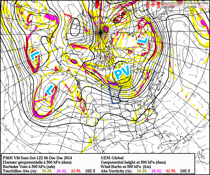
The general gist of the pattern evolution is this: over the next few days, a very strong frontal zone over the northern Pacific will shift eastwards alongside a train of upper-level disturbances reflected at the surface by a very intense low pressure system – bottoming out today at 950mb or so. This intense low will become stacked east of the Aleutians and absorb several weaker, more disorganized disturbances, becoming a very impressive, large storm over the northeastern Pacific. This intense system will build an upper-level ridge over western North America, beginning the push of warm air. The second key ingredient is the evolution of the polar vortex that has been anchored over Hudson Bay for the last few weeks.
By this weekend, shown here in the GDPS 500mb height & vorticty forecast, several very potent low pressure systems – marked by the letter L – will begin building a ridge over western North America while the polar vortex – shown by “PV” – begins a slow trek eastwards.
Fortunately, a powerful low pressure system heading up the east coast with teleconnections to the polar vortex will help “push” the vortex from its resting place and rapidly shunt it eastwards over Greenland. This is the second key ingredient because the polar vortex over Hudson Bay[1] is what anchors the eastern Prairies into a northwesterly to northerly flow for such long periods of time, reinforcing colder air and shunting warmer air to our south. With the vortex skipping town, the arctic jet stream will retreat northwards and the warm air spreading northeastwards with the upper ridge will be able to spread eastwards across the Prairies unhindered.
It’s a very interesting situation that highlights how stable the ridge-trough pattern that is so common is; in order for us to be kicked out of this pattern that has brought us a very cold November, we need very potent, significant storms on both coasts at the same time disrupting the upper-level pattern enough to get things moving again.
Within the warming pattern, we’ll see relatively warm and cool spells as disturbances ripple across the Prairies , but overall it looks quite dry in the Red River Valley as daytime highs climb into the -5 to 0°C through the second half of next week with the possibility of above-zero temperatures late into the week through the weekend. different from
Its worth noting given how much press the term “polar vortex” gets lately that this is a completely normal feature that is dominant over Hudson Bay for huge swaths of winter every single year. ↩