Hot Weather Continues

The summer-like temperatures seen in Winnipeg over the past couple days will continue into the weekend with daytime highs 10°C above normal. A cold front will finally push through on Saturday evening, bringing an end to the exceptional warmth and ushering in a return to seasonal temperatures.

Today will be a gorgeous day in the Red River Valley with light winds and daytime highs near 25°C with a bit of a southwesterly wind. Expect a few clouds tonight with a low near 10°C.

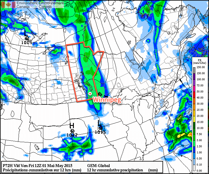
Tomorrow will be a more interesting day as a more organized southerly flow develops over the Red River Valley ahead of an approaching low pressure system. Temperatures will climb to around 27°C while a meager amount of moisture pools through the Red River Valley ahead of an approaching trough. As the trough moves into the Red River Valley, it’s looking quite possible that we may see a few thunderstorms develop, however the chance is largely conditional.

Winnipeg Forecast Sounding for the afternoon of Saturday May 2, 2015
This forecast sounding valid Saturday afternoon for Winnipeg from the NAM model shows a deep layer of instability, adequate moisture and favorable shear for thunderstorm development.

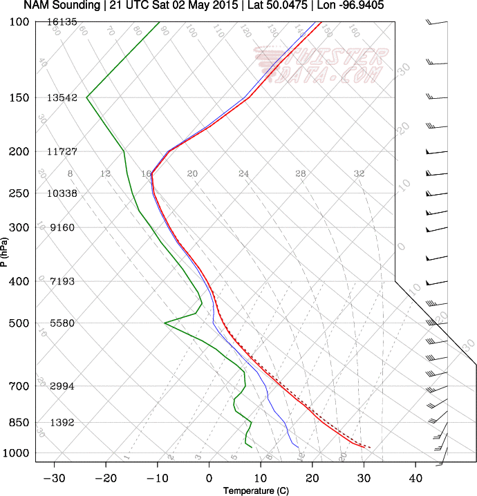
Given the fairly low amount of moisture available, cloud bases would likely be very high; the forecast sounding indicates cloud bases near 10,000ft which would mean the biggest threat from the storms would be strong wind gusts. Some hail might be a threat further south in North Dakota, perhaps sneaking onto extreme southeastern Manitoba, but overall it looks more like we’ll see a few weak thunderstorms develop capable of producing some fairly gusty winds. The overall environment, save for the lack of moisture, looks quite favorable for the development of the storms, though. Winds will generally be out of the south to southwest at around 30 gusting 50km/h with a slight chance for some 50 gusting 70km/h winds in the afternoon.

Some cloud will linger overnight as temperatures dip to around 9°C with winds relatively light out of the west to northwest.

Sunday will bring a bit of cloudiness and slightly cooler temperatures with a daytime high of “only” 19°C. Winds could be gusty out of the northwest for a few hours beginning in the morning before settling down to 30 gusting 50km/h for the afternoon. Sunday night looks mainly clear with a low near 5°C.

Summer Warmth Arrives

Summer-like warmth has arrived for Winnipeg and the Red River Valley thanks to an upper-level ridge moving into the region that will spread warm air over Manitoba for the coming days. Some rain looks likely on Thursday evening as a “cool” front passes, but the other days through the second half of the week look beautiful with plenty of sun to go along with the warmer weather.

Today will be a mainly sunny day with a high near 21°C. Winds will remain fairly light through the day as well. With an overnight low near 8°C or so, the warmth should hang on into the evening making for a pleasant evening to be outside.

Thursday will bring a fair amount of cloud, however the sun will still poke out a few times through the day. Winds will be breezy out of the south, picking up to around 30–40km/h with gusts to 50–60km/h or so. Heading into the second half of the afternoon should really bring in the thicker cloud ahead of the approaching “cool” front. A band of showers will move in sometime between 6–9PM and last for a few hours as they move through.

RDSP 12hr. Precipitation Accumulation
The RDPS shows around 2mm of rain through much of southern Manitoba associated with the passage of a “cool” front on Thursday evening. Image above is total accumulations from Thursday evening at 7PM to Friday morning at 7AM.

Precipitation is expected to be fairly light, however, with total accumulations around 2mm, although if the odd convective cell gets going, some places may see closer to the 5mm mark. Winds will taper off with the passage of the front and temperatures will drop to around the 7°C mark with clearing skies overnight.

Friday will be another pleasant day with light winds, mainly sunny skies and a high near 21°C. Expect a low near 8°C on Friday night.

Pleasant Weather Returns

Winnipeg will see a reprieve from the below-normal temperatures this weekend as the ridge of high pressure that’s brought the cooler weather shuffles off to the . In its place, a southerly flow will return warmer air to the region with temperatures climbing back to near the seasonal mark.

Over the next few days, no significant weather is expected in Winnipeg or the Red River Valley. Today will start off with some lingering cloud that will clear out through the day. Temperatures will climb to a high of around 13°C with a light southeasterly wind. Expect a low near 0°C under clear skies tonight.

Saturday will bring mainly sunny skies, light southeasterly winds and a high near 16°C. Saturday night will see a low near +2°C with a bit of cloud cover.

RDPS forecast Temperature for Friday Afternoon
The RPDS weather model is forecasting highs climbing above 15°C in Winnipeg on Saturday afternoon.

Sunday’s high will also be near 16°C, however with a few more clouds than Saturday. The temperature will drop to 7°C or so on Sunday night with increasing cloudiness overnight.

Cold Trough over Manitoba & Ontario

Cool And Sunny, Becoming Unsettled

Temperatures will be stuck well below-normal for late April through the remainder of the week as a stationary long-wave trough locks Manitoba into a pool of cold Arctic air. To make lemonade of it, skies will at least be quite sunny and winds light making things comparatively pleasant to how the week started.

The next two days will be very similar and very quiet weather-wise. Both today and tomorrow will bring mainly sunny skies, light winds and high temperatures near +5°C. Tonight will be another brisk evening with a low near –7°C while tomorrow night will bring slightly warmer temperatures with a low near –3°C. All of these temperatures are well below normal, though. Daytime highs will be about 8°C below normal[1], a far cry from the 10–15°C above normal we saw last week, and overnight lows will be 4–8°C below normal.[2]

RDPS 500mb Winds valid 12Z April 22th, 2015
The 500mb wind pattern Wednesday morning shows a highly amplified ridge over Alberta & the Western Arctic diving into a very deep trough over Manitoba & Ontario.

By Friday, the stagnant ridge-trough pattern that has set up over North America will begin to break down. Throughout the day, Southern Manitoba will increasingly come under the influence of a trough of low pressure stretching from a low tracking through South Dakota to a low lifting through Alberta. Out ahead of the South Dakota low, it’s likely that some flurries will develop along the US border in southwestern Manitoba and spread east along border regions through the day. At this point, it looks highly probable that any flurry activity will remain south of Winnipeg. That being said, Winnipeg will see increasing cloud cover and a fairly cool high of just 4°C. Clouds should clear out Friday night with a low near –4°C.

Long Range: A Shift To a Wetter Pattern?

The long range forecast is a little tricky at this point, however we can break it down into two categories of uncertainty: timing and weather pattern. The second there’s a fair amount of confidence in; the timing, however, is a lot more difficult. The current long-wave weather pattern over North America is known as a blocking pattern. These weather patterns are very stable configurations of the jet stream and other upper-level features that result in stagnant weather patterns; these can be stretches of hot, dry weather in the summer[3] or long periods of well below-seasonal temperatures.[4]

Weather models are quite good at forecast what sort of weather pattern may develop when the blocking pattern breaks down, however they are generally quite poor at the actual timing of the break-down. This is because to shift these very stable features, significant changes in the long-wave pattern have to develop across huge distances, and those changes can be very difficult to forecast accurately.

That being said, we should start to see our current weather pattern break down this weekend, driven by an approaching low that will drive a wedge into the elongated upper ridge over the west coast as well as the retrogression of an upper-level low[5] from Ontario. As this happens, cool weather will blanket much of the Prairies – although it won’t likely be any cooler than we’re seeing now – and it looks like there will be an increased chance of precipitation through the Southern Prairies, perhaps even multiple low pressure systems coming through.

All to say it’s going to go from cool and dry to cool and, quite likely, unsettled through the coming weekend. Looking even further ahead, it does look like next week we’ll see a return to seasonal temperatures.


  1. Normal daytime highs for late-April in Winnipeg are around 13°C.  ↩
  2. Normal overnight lows for late-April in Winnipeg are around 0°C.  ↩
  3. Under what’s known as an omega block.  ↩
  4. This happens when an area gets stuck underneath a cold trough; this is what’s happening over Manitoba right now.  ↩
  5. A low pressure system “retrogrades” when it’s motion becomes opposite that of the usual motion; in our case, it’s when a low moves from east to west instead of west to east.  ↩